26 easy-to-follow walk, route maps of all grades on OS Explorer Map 146 Dorking, Box Hill & Reigate
Twenty-six easy-to-follow walk, route maps of all grades on OS Explorer Map 146 Dorking, Box Hill & Reigate in Walk Grade OrderTap/mouse over a coloured circle (1-3 easy walks, 4-6 moderate walks, 7-9 hard walks) and click to select.
You can use these checkboxes to show only the grades of walk you are interested in:-
Twenty-six easy-to-follow walk, route maps of all grades on OS Explorer Map 146 Dorking, Box Hill & Reigate in Walk Grade Order
Scroll down the list of walks below & click on each walk title (in blue) to locate it on the map above.
See this list of walks, routes & maps in:
Grade Order | Length Order | Time Order | Walk Number or Start Location Order
NB. To reverse (toggle) this order, click Grade Order again
   |
Vital Statistics:
| Length: | 5.5 miles (9 km) |
| Ascent: | 768ft (234m) |
| Time: | 3 hrs |
| Grade: |  |
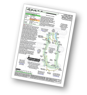
Route Summary:
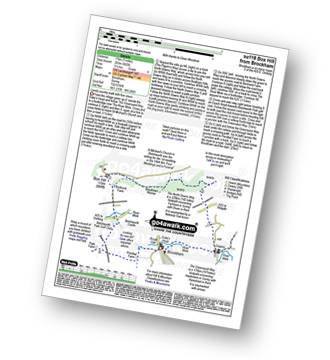
Friday Street - Abinger Common - Abinger Bottom - The Greensand Way - Leith Hill - Shakes Hill - Whitberry Hill - Stable Copse - Bushy Wood - Friday Street
|
Vital Statistics:
| Length: | 7 miles (11 km) |
| Ascent: | 1,115ft (340m) |
| Time: | 3½ hrs |
| Grade: |  |
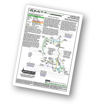
Route Summary:
Car Park S of Mickleham - River Mole - Norbury Park House - Fetcham Downs - Westhumble - The North Downs Way - Box Hill - Car Park S of Mickleham
|
Vital Statistics:
| Length: | 7.5 miles (12 km) |
| Ascent: | 417ft (127m) |
| Time: | 3.25hrs |
| Grade: | |
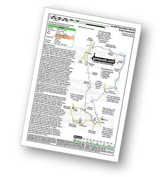
Route Summary:
Outwood - Windmill - Outwood Common - Shepheard's Hurst - Burstow Farm - Henshaw Farm - Laundry Cottage - Cuckseys Farm - Poundhill Wood - Outwood Swan Sanctuary - Outwood
|
Vital Statistics:
| Length: | 5.5 miles (9 km) |
| Ascent: | 1,001ft (305m) |
| Time: | 3 hrs |
| Grade: | |
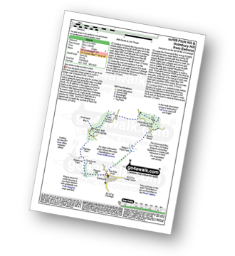
Route Summary:
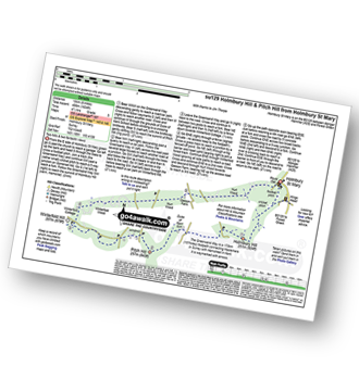
Ewhurst - Coneyhurst Gill - Rapsley Farm - Pitch Hill - The Greensand Way - Duke of Kent School - Holmbury Hill - Radnor Place Farm - Ewhurst
|
Vital Statistics:
| Length: | 4.5 miles (7 km) |
| Ascent: | 236ft (72m) |
| Time: | 2 hrs |
| Grade: |  |
Route Summary:
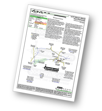
Charlwood - The Sussex Border Path - Barfield Farm - Greenings Farm - Glover's Wood Nature Reserve - Charlwood
|
Vital Statistics:
| Length: | 5.25 miles (8.5 km) |
| Ascent: | 715ft (218m) |
| Time: | 2.75hrs |
| Grade: | |
Route Summary:
Ranmore Common - Tanner's Hatch (Youth Hostel) - Bagden Farm - Crabtree Cottage - Chapel Farm - Westhumble Church - The North Downs Way - Ashcombe Wood - Denbies - St Barnabus Church - Ranmore Common
|
Vital Statistics:
| Length: | 6.25 miles (10 km) |
| Ascent: | 752ft (229m) |
| Time: | 3 hrs |
| Grade: | |

Route Summary:
Westcott - Mill Pond - The Greensand Way - Sylvanus Wood - Stable Copse - Bushy Wood - Friday Street - Tilling Bourne - Horsley Copse - Wotton - Vale Farm - Westcott
|
Vital Statistics:
| Length: | 6.25 miles (10 km) |
| Ascent: | 141ft (43m) |
| Time: | 2½ hrs |
| Grade: | |
Route Summary:
Lingfield - Park Farm - Puttenden Manor - Haxted Watermill - River Eden - Eden Brook - Cernes Farm - Starborough Castle - St Piers School - Lingfield Railway Station - Lingfield
|
Vital Statistics:
| Length: | 6.25 miles (10 km) |
| Ascent: | 286ft (87m) |
| Time: | 2½ hrs |
| Grade: | |
Route Summary:
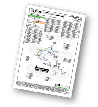
Leigh - Clayhill Farm - Gad Brook - Denby's Wood - St Michael's Church - Betchworth - Wonham Manor - Ricebridge Farm - Skeets Farm - Leigh
|
Vital Statistics:
| Length: | 7 miles (11 km) |
| Ascent: | 962ft (293m) |
| Time: | 3½ hrs |
| Grade: | |
Route Summary:
Brockham - The Greensand Way - St Michael's Church - Betchworth - The North Downs Way - Brockham Warren - Box Hill - Betchworth Park Golf Club - Park Farm - Pondtail Farm - Brockham
|
Vital Statistics:
| Length: | 10.25 miles (16.5 km) |
| Ascent: | 1,933ft (589m) |
| Time: | 5.75hrs |
| Grade: |  |
Route Summary:
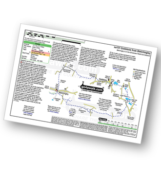
Holmbury St Mary - The Greensand Way - Holmbury Hill - Radnor Place Farm - Ewhurst - Rapsley Farm - Pitch Hill - Winterfold Hill - Winterfold Wood - Hurt Wood - Holmbury St Mary
|
Vital Statistics:
| Length: | 6.5 miles (10.5 km) |
| Ascent: | 542ft (165m) |
| Time: | 3 hrs |
| Grade: | |

Route Summary:
Farthing Downs - Fairdean Downs - Chaldon Church - Chaldon - The North Downs Way - Ockley Hill - Hilltop House - Willey Park Farm - Caterham - Farthing Downs
|
Vital Statistics:
| Length: | 4.75 miles (7.5 km) |
| Ascent: | 466ft (142m) |
| Time: | 2.25hrs |
| Grade: | |
Route Summary:
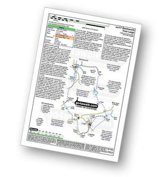
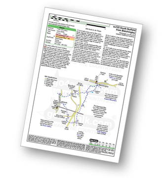
Bletchingley - The Greensand Way - Steners Hill - South Nutfield - Crabtree House - Henhaw Farm - Castlehill Farm - Bletchingley
|
Vital Statistics:
| Length: | 3.75 miles (6 km) |
| Ascent: | 387ft (118m) |
| Time: | 1.75hrs |
| Grade: | |
Route Summary:
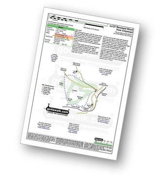
Chipstead - Chipstead Bottom - Fames Rough - Perrotts Farm - Ruffett Wood - Chipstead
|
Vital Statistics:
| Length: | 8.25 miles (13 km) |
| Ascent: | 1,634ft (498m) |
| Time: | 4½ hrs |
| Grade: |  |
Route Summary:
Holmbury St Mary - The Greensand Way - Holmbury Hill - Duke of Kent School - Pitch Hill - Winterfold Hill - Winterfold Wood - Hurt Wood - Holmbury St Mary
|
Vital Statistics:
| Length: | 7.25 miles (11.5 km) |
| Ascent: | 873ft (266m) |
| Time: | 3½ hrs |
| Grade: | |
Route Summary:
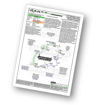
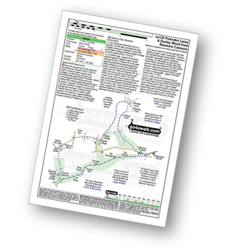
Ranmore Common - Yewtree Farm - Polesden Lacey - Pigden Cottage - Hogden Cottage - Friars Farm - Dunley Wood - The North Downs Way - White Downs - Burnetts Leaf - The Roadabouts - The Spains - Ranmore Common
|
Vital Statistics:
| Length: | 7.25 miles (11.5 km) |
| Ascent: | 752ft (229m) |
| Time: | 3½ hrs |
| Grade: | |
Route Summary:
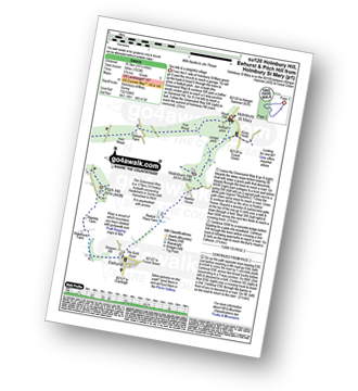
Bletchingley - The Greensand Way - Coldharbour Farm - Hobgarden Wood - Leigh Place - Glebe Water - Bay Pond - Godstone - Brewer Street - Bletchingley
|
Vital Statistics:
| Length: | 6.5 miles (9.5 km) |
| Ascent: | 689ft (210m) |
| Time: | 2.75hrs |
| Grade: | |

Route Summary:
Oxted - The Greensand Way - Limpsfield - The North Downs Way - Tandridge Hill - Townland Pool - Oxted Mill - The Greensand Way - Oxted
|
Vital Statistics:
| Length: | 4.5 miles (7 km) |
| Ascent: | 151ft (46m) |
| Time: | 1.75hrs |
| Grade: |  |
|
Vital Statistics:
| Length: | 2.75 miles (4.5 km) |
| Ascent: | 151ft (46m) |
| Time: | 1.25hrs |
| Grade: | |
Route Summary:
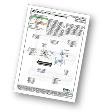
Brockham - The Greensand Way - The River Mole - St Michael's Church - Betchworth - Denby's Wood - Oldpark Wood - Brockham
|
Vital Statistics:
| Length: | 4.75 miles (7.5 km) |
| Ascent: | 647ft (197m) |
| Time: | 2½ hrs |
| Grade: | |

Route Summary:
Westcott - Coomb Farm - The North Downs Way - The Rondabouts - The Spains - Ranmore Common - The Greensand Way - Westcott
|
Vital Statistics:
| Length: | 6.75 miles (11 km) |
| Ascent: | 243ft (74m) |
| Time: | 2½ hrs |
| Grade: | |
Route Summary:
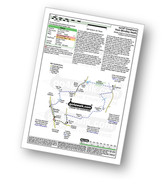
Blindley Heath - Ardenrun Farm - Crowhurst Place - Crowhurst - Ashen Plantations - Gays Cottages - Comforts Place Farm - Oak Tree Farm - Blindley Heath
|
Vital Statistics:
| Length: | 5.5 miles (9 km) |
| Ascent: | 466ft (142m) |
| Time: | 2½ hrs |
| Grade: | |

Route Summary:
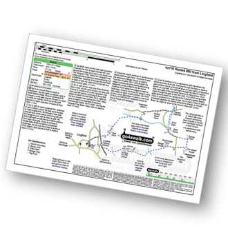
Tattenham Corner - Epsom Downs Racecourse - Langley Cale - The Warren - Nohome Farm - Downs View Wood - Walton On The Hill - The Nere - Withybed Corner - Walton Downs - Tattenham Corner - Epsom Downs Racecourse.
|
Vital Statistics:
| Length: | 4.75 miles (7.5 km) |
| Ascent: | 630ft (192m) |
| Time: | 2½ hrs |
| Grade: | |
Route Summary:
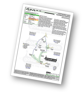
Ranmore Common - Yewtree Farm - Polesden Lacey - Connicut Wood - Freehold Wood - Tanner's Hatch (Yough Hostel) - Ranmore Common
|
Vital Statistics:
| Length: | 8.5 miles (13.5 km) |
| Ascent: | 866ft (264m) |
| Time: | 4 hrs |
| Grade: | |
Route Summary:
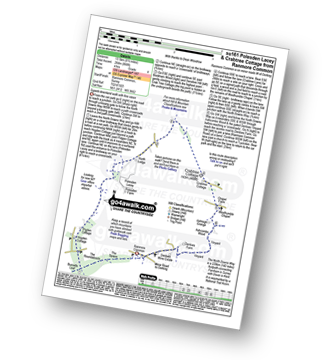
Ranmore Common - The North Downs Way - The Spains - The Roundabouts - Burnetts Leaf - Hogden Cottage - Pigden Cottage - Polesden Lacey - Bookham Wood - Crabtree Cottage - Chapel Farm - Westhumble Chapel - Ashcombe Wood - St Barnabus Church - Ranmore Common
|
Vital Statistics:
| Length: | 4 miles (6.5 km) |
| Ascent: | 420ft (128m) |
| Time: | 2 hrs |
| Grade: | |
Route Summary:
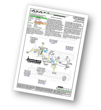
Godstone - Glebe Water - Church Town - Leigh Place - Oakpark Wood - Tandridge - The Greensand Way - Enterdent - Tilburstowhill Common - Godstone
See this list of walks, routes & maps in:
Grade Order | Length Order | Time Order | Walk Number or Start Location Order
NB. To reverse (toggle) this order, click Grade Order again


