
![]()
Great Coum
687m (2254ft)
The Southern Dales Area, The Yorkshire Dales, Cumbria, England
Tap/mouse over a coloured circle (1-3 easy walks, 4-6 moderate walks, 7-9 hard walks) and click to select.
Not familiar with this top?
You can walk/hike to the top of Great Coum by using this easy‑to‑follow route map:
Walk c300 Crag Hill and Great Coum from Dent
High moorland views
   |
|---|
Vital Statistics:
| Length: | 9ml (14.5km) |
|---|---|
| Ascent: | 19,112ft (583m) |
| Time: | 5.25hrs |
| Grade: |  (Moderate) (Moderate) |

Route Summary:
Dent - Flinter Gill - Crag Hill (Great Coum) - Great Coum - Lancashire County Stone - Blea Gills - Nun House Outrake - The Dales Way - River Dee - Dent
See Great Coum and the surrounding tops on our free-to-access 'Google Style' Peak Bagging Maps:
The Southern Dales Area of The Yorkshire Dales National Park
Less data - quicker to download
The Whole of The Yorkshire Dales National Park
More data - might take a little longer to download
See Great Coum and the surrounding tops on our unique, downloadable, PDF Peak Bagging Map:

NB: Whether you print off a copy or download it to your phone, this PDF Peak Baggers' Map might prove incredibly useful when your are up there on the tops and you cannot get a phone signal.
You can find Great Coum & all the walks that climb it on these unique free-to-access Interactive Walk Planning Maps:
1:25,000 scale OS Explorer Map (orange/yellow covers):
1:50,000 scale OS Landranger Map (pink/magenta covers):
 Fellow go4awalkers who have already walked, climbed, scaled, summited, hiked & bagged Great Coum
Ruth Nolan walked up Great Coum on June 27th, 2022 [from/via/route] Dent, Flinter Gill, Crag Hill, Great Coum, Green Hill [with] Solo [weather] Scudding clouds, light breeze
David Hughes climbed it on December 22nd, 2020 [from/via/route] peck farm [with] DD DG Waz
Adrian Howard bagged it on July 25th, 2017 [from/via/route] From road at High Moss SE of summit, then on to Crag Hill trig.
Stella Nuttall hiked Great Coum on October 17th, 2018 [from/via/route] From Lack House Farm. Ny 129 Gragateth, Great Coum Green Hill & Crag Hill. We didn't see anyone else on this walk until we saw firstly 3 people in orange boiler suits & then 2 men in yellow boiler suits approaching in the distance, quite surreal. They had all been pot holing & were making their way back to the farm. We had lunch by the waterfall in the sun. [with] Stella, Ann, Sally Christine and Kath. [weather] Misty to start with but when this lifted the views were awesome. - Very wet on the top between Gragareth & Great Coum.
Margaret Richards summited on March 24th, 2017 [from/via/route] ny129 Gragareth & Great Coum from Leck Fell House [with] Don and Mike [weather] sunny & snow
To add (or remove) your name and experiences on this page - Log On and edit your Personal Mountain Bagging Record
. . . [see more walk reports]
More Photographs & Pictures of views from, on, or of, Great Coum


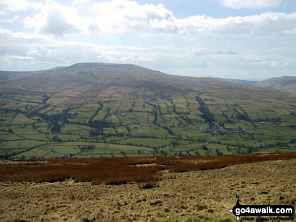
Great Coum (left), Greyrigg Pike and Little Coum (right) from the lower slopes of Grayrigg Forest

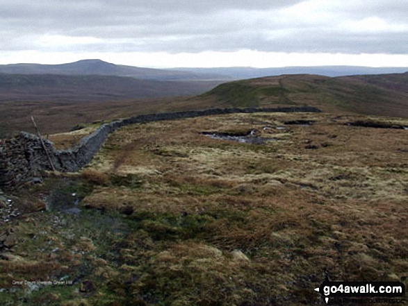
Ingleborough (in the distance left) and Green Hill (Gragareth) (foreground right) from Great Coum

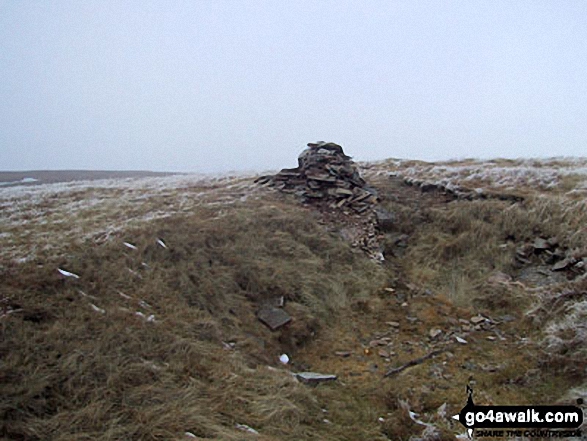
County Stone, marking the north east tip of Lancashire, located 750m due south of the summit of Great Coum
Send us your photographs and pictures on, of, or from Great Coum
If you would like to add your walk photographs and pictures to this page, please send them as email attachments (configured for any computer) along with your name to:
and we shall do our best to publish them.
(Guide Resolution = 300dpi. At least = 660pixels (wide) x 440 pixels (high).)

You can also submit photos via our Facebook Page.
NB. Please indicate where each photo was taken and whether you wish us to credit your photos with a Username or your First Name/Last Name.


