
![]()
Bera Bach
807m (2649ft)
The Carneddau, Snowdonia, Gwynedd, Wales
Bera Bach means 'Little Haystack' in Welsh.
The summit of Bera Bach is marked by a rocky outcrop.

Not familiar with this top?
You can walk/hike to the top of Bera Bach by using either of these 2 easy‑to‑follow route maps:
Walk gw171 Bera Bach from Bont Newydd
Fine views of the coast & Carneddau
   |
|---|
Vital Statistics:
| Length: | 8.25ml (13km) |
|---|---|
| Ascent: | 2,795ft (852m) |
| Time: | 5.75hrs |
| Grade: |  (Moderate) (Moderate) |
Route Summary:
Bont Newydd - Afon Rhaeadr-fawr - Aber Falls - Rhaeadr-fawr (Big waterall) - Afon Goch - Bera Mawr - Bera Bach - Drosgl - Gyrn Wigau - Rhaeadr-bach (Small waterfall) - Bont Newydd
Walk gw183 Bera Bach, Foel Grach and Drum (Carneddau) from Bont Newydd
Fine views of the coast and the Carneddau
|
|---|
Vital Statistics:
| Length: | 14.75ml (23.5km) |
|---|---|
| Ascent: | 3,890ft (1,186m) |
| Time: | 9.25hrs |
| Grade: |  (Hard) (Hard) |

Route Summary:
Bont Newydd - Afon Rhaeadr-fawr - Aber Falls (Rhaeadr-fawr) - Afon Gam - Gyrn Wigua - Drosgl - Bera Bach - Bera Mawr - Yr Aryg - Carnedd Gwenllian (Carnedd Uchaf) - Foel Grach - Foel-fras - Drum (Carneddau) - Carnedd y Ddelw - Yr Orsedd - Roman Road - Llyn Anafon Access Track - Bont Newydd
See Bera Bach and the surrounding tops on our free-to-access 'Google Style' Peak Bagging Maps:
The Carneddau of Snowdonia National Park
Less data - quicker to download
The Whole of Snowdonia National Park
More data - might take a little longer to download
See Bera Bach and the surrounding tops on our unique, downloadable, PDF Peak Bagging Map:

NB: Whether you print off a copy or download it to your phone, this PDF Peak Baggers' Map might prove incredibly useful when your are up there on the tops and you cannot get a phone signal.
You can find Bera Bach & all the walks that climb it on these unique free-to-access Interactive Walk Planning Maps:
1:25,000 scale OS Explorer Map (orange/yellow covers):
1:50,000 scale OS Landranger Map (pink/magenta covers):
 Fellow go4awalkers who have already walked, climbed, scaled, summited, hiked & bagged Bera Bach
Melfyn Parry walked up Bera Bach on May 15th, 2022 [from/via/route] Start point is car park in Bethesda, route taken involved walking around Moelwyn Faban, then up LLefn. Walked on path around Y Gyrn & followed this across to Drosgl. Took path around Drosgl up towards Bera Bach & ascended summit from South side. Retraced steps & then walked across heathland to ascend summit of Bera Mawr. This was a good short scramble & the two monoliths do resemble Adam & Eve on Tryfan. Too windy to try anything heroic so retraced steps to base & then followed path around base of Bera Bach to follow path down over Gyrn Wigau before returning to carpark via Gerlan. [with] On my own [weather] Great initially, very warm. Wind picked up about 11am so added a layer. Spots of rain towards the end but a great day out. - Could have added peaks of Y Gyrn & Drosgl but have done these before so saved my energy for the Bera's. 15km walk today.
Sion Britton climbed it on May 1st, 2021 [from/via/route] O Bethesda [with] Solo [weather] Braf
Andy Buxton bagged it during April, 1991 [from/via/route] From Aber Falls: Bera Mawr, Bera Back Carnedd Gwenllian, Foel Grach, Foel Fras
Christina Lander hiked Bera Bach on September 29th, 2018 [from/via/route] Bont Newydd (Abergwyngregin) - Drum - Foel Fras - Carnedd Gwenllian - Bera Bach - Drosgl - Aber Falls - Bont Newydd [with] Dick & Meg [weather] A fine, dry day but very windy on the tops. Plenty of sunny spells. - We struggled to find our way between Drosgl & Aber Falls. Crossing the river at the top of the falls was challenging!
Mark Davidson summited on August 6th, 2002 [with] Alone [weather] Warm with high cloud but a bit hazy - Route directions for this walk are excellent
To add (or remove) your name and experiences on this page - Log On and edit your Personal Mountain Bagging Record
. . . [see more walk reports]
More Photographs & Pictures of views from, on, or of, Bera Bach
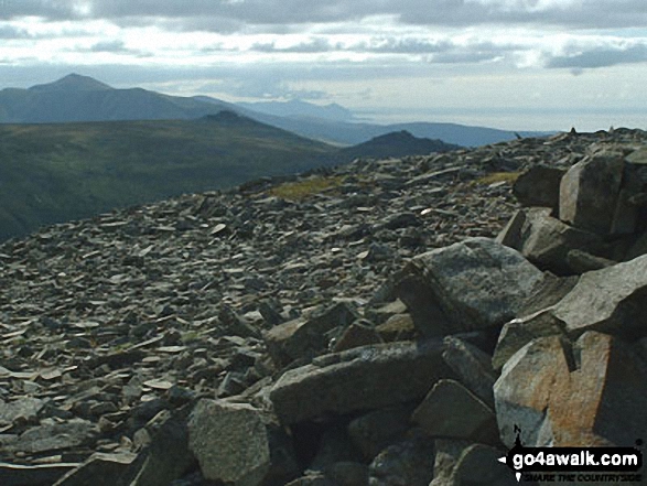
Elidir Fawr, Bera Bach and Bera Mawr, with Yr Eifl in the distance from Llwytmor

Send us your photographs and pictures on, of, or from Bera Bach
If you would like to add your walk photographs and pictures to this page, please send them as email attachments (configured for any computer) along with your name to:
and we shall do our best to publish them.
(Guide Resolution = 300dpi. At least = 660pixels (wide) x 440 pixels (high).)

You can also submit photos via our Facebook Page.
NB. Please indicate where each photo was taken and whether you wish us to credit your photos with a Username or your First Name/Last Name.


