
![]()
Baugh Fell (Tarn Rigg Hill)
678m (2225ft)
The Northern Dales Area, The Yorkshire Dales, Cumbria, England
Tap/mouse over a coloured circle (1-3 easy walks, 4-6 moderate walks, 7-9 hard walks) and click to select.

Not familiar with this top?
   |
|---|
Vital Statistics:
| Length: | 11.25ml (18km) |
|---|---|
| Ascent: | 1,601ft (488m) |
| Time: | 5½ hrs |
| Grade: |  (Hard) (Hard) |

Route Summary:
Rawthey Bridge - River Rawthey - Holmes Moss - Rawthey Gill - Rawthey Gill Quarry - Rawthey Gill Foot - Baugh Fell (Tarn Rigg Hill) - Broken Gill - Tarn Rigg Hill - Knoutberry Haw - West Baugh Fell Tarn - Raven Thorn - Rawthey Bridge
See Baugh Fell (Tarn Rigg Hill) and the surrounding tops on our free-to-access 'Google Style' Peak Bagging Maps:
The Northern Dales Area of The Yorkshire Dales National Park
Less data - quicker to download
The Whole of The Yorkshire Dales National Park
More data - might take a little longer to download
See Baugh Fell (Tarn Rigg Hill) and the surrounding tops on our downloadable Peak Bagging Map in PDF format:

NB: Whether you print off a copy or download it to your phone, this PDF Peak Baggers' Map might prove incredibly useful when your are up there on the tops and you cannot get a phone signal.
You can find Baugh Fell (Tarn Rigg Hill) & all the walks that climb it on these unique free-to-access Interactive Walk Planning Maps:
1:25,000 scale OS Explorer Map (orange/yellow covers):
1:50,000 scale OS Landranger Map (pink/magenta covers):
 Fellow go4awalkers who have already walked, climbed, summited & bagged Baugh Fell (Tarn Rigg Hill)
Angela Moroney walked up Baugh Fell (Tarn Rigg Hill) on March 31st, 2021 [from/via/route] uldale house [with] Jane ludders [weather] sunny
Caroline Winter climbed it on August 10th, 2020 [from/via/route] Lay by on Grisedale road, acsent on right of fence [with] Becky [weather] Warm with light Easterly wind - Weather wet, cold & poor visibility last time here, so took advantage to bag on a good day. Tedious slog up never ending wall. Worked out peak from fences & tarns, as no obvious feature. Nicer walk down, as views towards railway in distance.
Kevin Foster bagged it on August 24th, 2017 [from/via/route] Swarth Fell [with] Henry [weather] Cloudy - First, I have to say the picture someone has supposedly taken of Tarn Rigg Hill the summit of Baugh Fell is incorrect & is in fact the trig point on Knoutberry Haw the next summit along the ridge. Tarn Rigg Hill has no cairn (and no trig point). Next, the route described in the Nuttall book is a direct A to B & traverses some very rough terrain in places. Holme Moss Hill is very unpleasant & my advice would be to try & avoid at all costs (even at the risk of a huge detour). The bog & peat hags just below Tarn Rigg Hill were also horrendous but hard to avoid when your objective lies just beyond them. On a positive note, the series of waterfalls as you climb beside Rawthey Gill & Swere Gill were breathtakingly beautiful. However, in summary I have to say that Baugh Fell is a massive fell & deserving of a full days walk in itself & doesn't need to be tagged on to the Wild Boar Fell walk for the sake of it. I think in future, I might split some of the Nuttall walks in order to make them more manageable (and dare I say enjoyable).
Tony Rogerson hiked Baugh Fell (Tarn Rigg Hill) on June 18th, 2016 [from/via/route] Rawthey Bridge Tarn Rigg Hill Knoutberry Haw Bluecaster [with] Caz Floss [weather] Dry Sunny at first Cloudy later - Bit of a slog
Elaine Grayson summited on September 3rd, 2015 [from/via/route] go 4 a walk route c382 [with] Robin [weather] Cloudy light rain
To add (or remove) your name and experiences on this page - Log On and edit your Personal Mountain Bagging Record
. . . [see more walk reports]
More Photographs & Pictures of views from, on or of Baugh Fell (Tarn Rigg Hill)

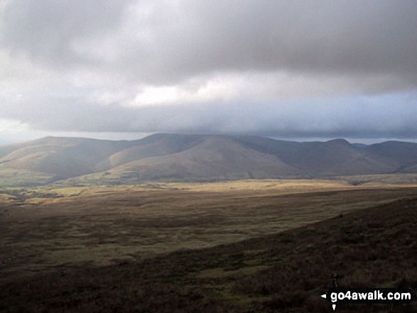
The view north west to the Lake District from Baugh Fell (Tarn Rigg Hill)

Send us your photographs and pictures on, of, or from Baugh Fell (Tarn Rigg Hill)
If you would like to add your walk photographs and pictures to this page, please send them as email attachments (configured for any computer) along with your name to:
and we shall do our best to publish them.
(Guide Resolution = 300dpi. At least = 660pixels (wide) x 440 pixels (high).)

You can also submit photos via our Facebook Page.
NB. Please indicate where each photo was taken and whether you wish us to credit your photos with a Username or your First Name/Last Name.


