The Mountains, Peaks, Tops and Hills in The Yorkshire Dales, Cumbria, North Yorkshire with all the tops you have already bagged in first & then the ones you are yet to climb second.
The Yorkshire Dales National Park, Cumbria, North Yorkshire includes The Howgills Fells, The Northern Dales and The Southern Dales areas of The Yorkshire Dales National Park.
If you count only the Deweys there are 38 tops to climb, bag & conquer and the highest point is Sugar Loaf (Horse Head Moor) at 609m (1,999ft).
To see these Mountains, Peaks, Tops and Hills displayed in different ways - see the options in the left-hand column and towards the bottom of this page.
![]() Your Personal Bagging Record for The Yorkshire Dales
Your Personal Bagging Record for The Yorkshire Dales
LOG ON and RELOAD this page to show which Mountains, Peaks, Tops and Hills you have already climbed, bagged & conquered [. . . more details]
Scroll down this list of mountains, peaks, tops & hills below and tap/click on each name (in blue) to locate it on the map above.
See this list in: Alphabetical Order | Height Order‡
To reverse the order select the link again.
Mountain, Peak, Top or Hill already bagged:
Bagged
Top yet to be climbed, bagged & conquered:
Bagged

![]()
1. Sugar Loaf (Horse Head Moor)
609m (1999ft)
Dewey
See more details, photos, trip reports and easy-to-follow walks up Sugar Loaf (Horse Head Moor)
![]()
2. Arant Haw
605m (1985ft)
Dewey
See more details, photos, trip reports and easy-to-follow walks up Arant Haw
![]()
3. Green Bell
605m (1985ft)
Dewey
See more details, photos, trip reports and easy-to-follow walks up Green Bell
![]()
4. Little Whernside
604m (1982ft)
Dewey
See more details, photos, trip reports and easy-to-follow walks up Little Whernside
![]()
5. High Green Field Knott (Cosh Knott)
602m (1975ft)
Dewey
![]()
6. Woldside
596m (1956ft)
Dewey
See more details, photos, trip reports and easy-to-follow walks up Woldside
![]()
7. Simon's Seat (Howgills)
587m (1926ft)
Dewey
See more details, photos, trip reports and easy-to-follow walks up Simon's Seat (Howgills)
![]()
8. Hooksey
586m (1923ft)
Dewey
See more details, photos, trip reports and easy-to-follow walks up Hooksey
![]()
9. Blackstone Edge (Oxnop Common)
584m (1917ft)
Dewey
See more details, photos, trip reports and easy-to-follow walks up Blackstone Edge (Oxnop Common)
![]()
10. Great Pinseat (Whaw Moor)
583m (1913ft)
Dewey
See more details, photos, trip reports and easy-to-follow walks up Great Pinseat (Whaw Moor)
![]()
11. Hazelgill Knott
578m (1896ft)
Dewey
See more details, photos, trip reports and easy-to-follow walks up Hazelgill Knott
![]()
12. Meugher
575m (1887ft)
Dewey
See more details, photos, trip reports and easy-to-follow walks up Meugher
![]()
13. Brown Haw (North Moor)
574m (1884ft)
Dewey
See more details, photos, trip reports and easy-to-follow walks up Brown Haw (North Moor)
![]()
14. Kensgriff
574m (1883ft)
Dewey
See more details, photos, trip reports and easy-to-follow walks up Kensgriff
![]()
15. Naughtberry Hill
573m (1881ft)
Dewey
See more details, photos, trip reports and easy-to-follow walks up Naughtberry Hill
![]()
16. Pickerstone Ridge
565m (1854ft)
Dewey
See more details, photos, trip reports and easy-to-follow walks up Pickerstone Ridge
![]()
17. Park Fell (Ribblehead)
563m (1847ft)
Dewey
See more details, photos, trip reports and easy-to-follow walks up Park Fell (Ribblehead)
![]()
18. Wold Fell (Wold Fell Top)
558m (1831ft)
Dewey
See more details, photos, trip reports and easy-to-follow walks up Wold Fell (Wold Fell Top)
![]()
19. Aye Gill Pike
556m (1824ft)
Dewey
See more details, photos, trip reports and easy-to-follow walks up Aye Gill Pike
![]()
20. Hoove Faggergill
554m (1818ft)
Dewey
See more details, photos, trip reports and easy-to-follow walks up Hoove Faggergill
![]()
21. Grizedales
553m (1814ft)
Dewey
See more details, photos, trip reports and easy-to-follow walks up Grizedales
![]()
22. Height of Hazely
553m (1814ft)
Dewey
See more details, photos, trip reports and easy-to-follow walks up Height of Hazely
![]()
23. The Fleak (Conny Tammy Currack)
551m (1808ft)
Dewey
See more details, photos, trip reports and easy-to-follow walks up The Fleak (Conny Tammy Currack)
![]()
24. Rye Loaf Hill
547m (1795ft)
Dewey
See more details, photos, trip reports and easy-to-follow walks up Rye Loaf Hill
![]()
25. Dead Man's Hill
546m (1792ft)
Dewey
See more details, photos, trip reports and easy-to-follow walks up Dead Man's Hill
![]()
26. Kirkby Fell
546m (1791ft)
Dewey
See more details, photos, trip reports and easy-to-follow walks up Kirkby Fell
![]()
27. Redshaw Moss (Snaizhold Fell)
545m (1788ft)
Dewey
See more details, photos, trip reports and easy-to-follow walks up Redshaw Moss (Snaizhold Fell)
![]()
28. West Fell
542m (1779ft)
Dewey
See more details, photos, trip reports and easy-to-follow walks up West Fell
![]()
29. Parson's Pulpit
538m (1765ft)
Dewey
See more details, photos, trip reports and easy-to-follow walks up Parson's Pulpit
![]()
30. Castle Knott
536m (1759ft)
Dewey
See more details, photos, trip reports and easy-to-follow walks up Castle Knott
![]()
31. Harland Hill
535m (1756ft)
Dewey
See more details, photos, trip reports and easy-to-follow walks up Harland Hill
![]()
32. Blea Moor (Crag of Blea Moor)
535m (1755ft)
Dewey
See more details, photos, trip reports and easy-to-follow walks up Blea Moor (Crag of Blea Moor)
![]()
33. Uldale Head (Howgills)
532m (1746ft)
Dewey
See more details, photos, trip reports and easy-to-follow walks up Uldale Head (Howgills)
![]()
34. Proctor High Mark
531m (1743ft)
Dewey
See more details, photos, trip reports and easy-to-follow walks up Proctor High Mark
![]()
35. Harter Fell (Howgills)
521m (1709ft)
Dewey
See more details, photos, trip reports and easy-to-follow walks up Harter Fell (Howgills)
![]()
36. Blaydike Moss
510m (1674ft)
Dewey
See more details, photos, trip reports and easy-to-follow walks up Blaydike Moss
![]()
37. Cracoe Fell
507m (1663ft)
Dewey
See more details, photos, trip reports and easy-to-follow walks up Cracoe Fell
![]()
38. Cam Rakes (Oughtershaw Moss)
501m (1644ft)
Dewey
See more details, photos, trip reports and easy-to-follow walks up Cam Rakes (Oughtershaw Moss)
![]() Your Personal Bagging Record for The Yorkshire Dales
Your Personal Bagging Record for The Yorkshire Dales
LOG ON and RELOAD this page to show which Mountains, Peaks, Tops and Hills you have already climbed, bagged & conquered [. . . more details]
View these 38 Mountains, Peaks, Tops and Hills:
- On Three Downloadable PDFs you can print or save to your phone covering:
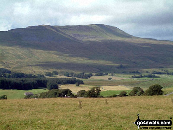 Whernside in The Yorkshire Dales
Photo: David Hayter
- On an Interactive Google Map with a list of tops below it.
(makes it easier to locate a particular top) - On a Detailed List in:
Alphabetical Order | Height Order - On one page with 'yet-to-be-bagged' listed 1st
& then 'already-bagged' tops listed 2nd in:
Alphabetical Order | Height Order - On one page with 'already-bagged' tops listed 1st
& then 'yet-to-be-bagged' tops listed 2nd in:
Alphabetical Order | Height Order
# Whether you print copies or download them to your phone, these Peak Baggers' Maps will prove incredibly useful if you want to know what's what when you are up in the mountains and cannot get a phone signal.
Is there a Mountain, Peak, Top or Hill missing from the above google map or list?


