The Mountains, Peaks, Tops and Hills in Dartmoor, Devon with all the tops you have already bagged in first & then the ones you are yet to climb second.
Dartmoor National Park is located in South West England, wholly within the county of Devon.
If you include just the Mountains (Hewitts), the Deweys and the Nuttalls there are 15 tops to climb, bag & conquer and the highest point is High Willhays at 622m (2,041ft).
To see these Mountains, Peaks, Tops and Hills displayed in different ways - see the options in the left-hand column and towards the bottom of this page.
![]() Your Personal Bagging Record for Dartmoor
Your Personal Bagging Record for Dartmoor
LOG ON and RELOAD this page to show which Mountains, Peaks, Tops and Hills you have already climbed, bagged & conquered [. . . more details]
Scroll down this list of mountains, peaks, tops & hills below and tap/click on each name (in blue) to locate it on the map above.
See this list in: Alphabetical Order‡ | Height Order
To reverse the order select the link again.
Mountain, Peak, Top or Hill already bagged:
Bagged
Top yet to be climbed, bagged & conquered:
Bagged

![]()
1. Beardown Tors
512m (1680ft)
Dewey
See more details, photos, trip reports and easy-to-follow walks up Beardown Tors
![]()
2. Cosdon Hill (Cawsand Hill)
551m (1808ft)
Dewey
See more details, photos, trip reports and easy-to-follow walks up Cosdon Hill (Cawsand Hill)
![]()
3. Cut Hill
603m (1979ft)
Dewey
See more details, photos, trip reports and easy-to-follow walks up Cut Hill
![]()
4. Great Links Tor
587m (1926ft)
Dewey
See more details, photos, trip reports and easy-to-follow walks up Great Links Tor
![]()
5. Great Mis Tor
539m (1768ft)
Dewey
See more details, photos, trip reports and easy-to-follow walks up Great Mis Tor
![]()
6. Hameldown Tor (Hamel Down)
532m (1746ft)
Dewey
See more details, photos, trip reports and easy-to-follow walks up Hameldown Tor (Hamel Down)
![]()
7. Hangingstone Hill (Dartmoor)
603m (1979ft)
Dewey
See more details, photos, trip reports and easy-to-follow walks up Hangingstone Hill (Dartmoor)

![]()
8. High Willhays
622m (2041ft)
Mountain (Hewitt) and Nuttall
See more details, photos, trip reports and easy-to-follow walks up High Willhays
![]()
9. Higher White Tor
525m (1723ft)
Dewey
See more details, photos, trip reports and easy-to-follow walks up Higher White Tor
![]()
10. Kitty Tor (Amicombe Hill)
585m (1919ft)
Dewey
See more details, photos, trip reports and easy-to-follow walks up Kitty Tor (Amicombe Hill)
![]()
11. North Hessary Tor
517m (1696ft)
Dewey
See more details, photos, trip reports and easy-to-follow walks up North Hessary Tor
![]()
12. Ryder's Hill
515m (1690ft)
Dewey
See more details, photos, trip reports and easy-to-follow walks up Ryder's Hill
![]()
13. Steeperton Tor
532m (1746ft)
Dewey
See more details, photos, trip reports and easy-to-follow walks up Steeperton Tor
![]()
14. White Ridge
506m (1660ft)
Dewey
See more details, photos, trip reports and easy-to-follow walks up White Ridge

![]()
15. Yes Tor
619m (2031ft)
Nuttall
See more details, photos, trip reports and easy-to-follow walks up Yes Tor
![]() Your Personal Bagging Record for Dartmoor
Your Personal Bagging Record for Dartmoor
LOG ON and RELOAD this page to show which Mountains, Peaks, Tops and Hills you have already climbed, bagged & conquered [. . . more details]
View these 15 Mountains, Peaks, Tops and Hills:
- On a Downloadable PDF you can Print or Save to your Phone#
- On an Interactive Google Map with a list of tops below it.
(makes it easier to locate a particular top) - On a Detailed List in:
Alphabetical Order | Height Order - On one page with 'yet-to-be-bagged' listed 1st
& then 'already-bagged' tops listed 2nd in:
Alphabetical Order | Height Order - On one page with 'already-bagged' tops listed 1st
& then 'yet-to-be-bagged' tops listed 2nd in:
Alphabetical Order | Height Order
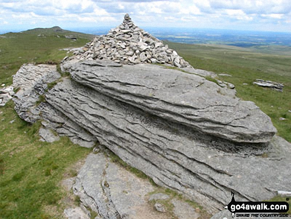 The summit of High Willhays in Dartmoor
Photo: David Rodgers
# Whether you print a copy or download it to your phone, this Peak Baggers' Map will prove incredibly useful if you want to know what's what when you are up in the mountains and cannot get a phone signal.
Is there a Mountain, Peak, Top or Hill missing from the above google map or list?


