UK Postcode TD8 - The 30 nearest easy-to-follow, circular walk route maps to you
The thirty nearest easy-to-follow, circular walk route maps to you in UK Postcode TD8 in Walk Grade Order
The UK cities, towns and villages in The Borders, Scotland that have TD8 in their UK Postcode include:
• Ancrum • Bairnkine • Bonjedward • Camptown • Chesters • Crailing • Crailinghall • Falla • Hartrigge • Hundalee • Huntford • Jedburgh • Langlee • Lanton • Mervinslaw • Mossburnford • Newton • Nisbet • Oxnam • Swanlaws • Swinside Hall •
Not familiar with the area around TD8?
See these 30 nearest walks to UK Postcode TD8 on a google map
   |
Vital Statistics:
| Length: | 7 miles (11 km) |
| Ascent: | 1,408ft (429m) |
| Time: | 4 hrs |
| Grade: |  |

Route Summary:
Towford Farm - Kale Water - Buchtrig Farm - Humblemoor Hill - Little Humblemoor - The Hows - Tronshaw Hill - Upper Chatto - Chatto - Towford Farm
|
Vital Statistics:
| Length: | 4 miles (6.5 km) |
| Ascent: | 1,057ft (322m) |
| Time: | 2.75hrs |
| Grade: |  |

Route Summary:
Tow Ford - Dere Street - Woden Law - Langside Law - Buchtrig Farm - Kale Water - Tow Farm.
|
Vital Statistics:
| Length: | 10 miles (16 km) |
| Ascent: | 2,238ft (682m) |
| Time: | 6 hrs |
| Grade: |  |

Route Summary:
Tow Ford - Dere Street - Woden Law - Langside Law - Buchtrig Farm - Humblemoor Hill - Little Humblemoor - The Hows - Tronshaw Hill - Upper Chatto - Chatto - Towford Farm - Kale Water - Tow Farm.
|
Vital Statistics:
| Length: | 8.75 miles (14 km) |
| Ascent: | 1,260ft (384m) |
| Time: | 4½ hrs |
| Grade: | |

Route Summary:
Morebattle - The St Cuthbert's Way - Kale Water - Grubbit Law - Cushat End - Hownam Law - South Cote - Howgate - Heavyside - Gateshaw - Morebattle
|
Vital Statistics:
| Length: | 7.5 miles (12 km) |
| Ascent: | 1,753ft (534m) |
| Time: | 4½ hrs |
| Grade: | |

Route Summary:
Rowhope Burn Bridge - River Coquet - Hindside Knowe - The Street - Swineside Law - Black Braes - Windy Rigg Top - Windy Gyle - Trows Burn - Rowhope Burn - Rowhope Burn Bridge
|
Vital Statistics:
| Length: | 9.5 miles (15 km) |
| Ascent: | 2,009ft (612m) |
| Time: | 5½ hrs |
| Grade: | |

Route Summary:
Wedder Leap - River Coquet - Rowhope Burn - Trows Burn - Windy Gyle - The Pennine Way - Hazely Law - Hepden Burn - Clennel St - Middle Hill - Fairhaugh - Barrow Burn - Barrowburn.
|
Vital Statistics:
| Length: | 11.25 miles (18 km) |
| Ascent: | 2,311ft (704m) |
| Time: | 6½ hrs |
| Grade: | |

Route Summary:
Wedder Leap - River Coquest - Rowhope Burn - Hindside Knowe - The Street - Swineside Law - Black Braes - Windy Rigg Top - Windy Gyle - Hazely Law - Usway Burn - Middle Hill - Fairhaugh - Barrow Burn - Barrowburn.
|
Vital Statistics:
| Length: | 8.25 miles (13 km) |
| Ascent: | 1,520ft (463m) |
| Time: | 4½ hrs |
| Grade: | |
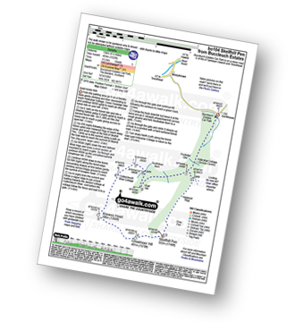
Route Summary:
Buccleuch Estates (Teviothead - Teviotdale) - Fouledge Syke - Alderybar Cottage - Harwood Rigg - Grey Pen - Skelfhill Pen - Greatmoor Hill - Knowes Head - Coltercleugh Shiel Cottage - Goat Hill - Buccleuch Estates (Teviothead).
|
Vital Statistics:
| Length: | 7.5 miles (12 km) |
| Ascent: | 1,316ft (401m) |
| Time: | 4 hrs |
| Grade: | |

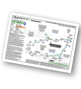
Route Summary:
Hethpool - The St Cuthbert's Way - White Hill (Hethpool) - East Laddie's Knowe - Laddie's Knowe or Betsy's Cairn - Black Bog (Haddon Hill) - Haddon Hill - Ring Chesters - Sheepfold - Eccles Cairn - England / Scotland Border - Elsdonnurn Farm - Elsdon Burn - The St Cuthbert's Way - Hethpool
|
Vital Statistics:
| Length: | 16.5 miles (26.5 km) |
| Ascent: | 3,144ft (958m) |
| Time: | 9.25hrs |
| Grade: |  |

Route Summary:
Hethpool - College Valley - Whitehall - Fleehope - Mounthooly - Birnie Brae - The Pennine Way - Red Cribs - Auchope Cairn - Cairn Hill - The Cheviot - Scald Hill - Goldcleugh - Lambden Burn - Dunsdale - Coldburn - Southernknowe - Whitehall - Hethpool
|
Vital Statistics:
| Length: | 13.75 miles (22 km) |
| Ascent: | 2,665ft (812m) |
| Time: | 7.75hrs |
| Grade: |  |

Route Summary:
Hethpool - The St Cuthbert's Way - Elsdon Burn - Elsdonburn Farm - Shank's Sike - Scaldhill Shank - Tom's Knowe - Tuppie's Sike - Eccles Cairn - England / Scotland Border - The Pennine Way - White Law - Steel Rig - Black Hag (Hethpool) - The Schil - Birnie Brae - Red Cribs - Mounthooly - Fleehope - Whitehall - College Valley - Hethpool
|
Vital Statistics:
| Length: | 7.25 miles (11.5 km) |
| Ascent: | 1,165ft (355m) |
| Time: | 3.75hrs |
| Grade: |  |
Route Summary:
Hethpool - The St Cuthbert's Way - Elsdon Burn - Elsdonburn Farm - Shank's Sike - Scaldhill Shank - Tom's Knowe - Tuppie's Sike - Eccles Cairn - England / Scotland Border - The Pennine Way - Tuppie's Grave - The Tongue - Maddie's Well - Madam Law - Wideopen Head - Trowup Burn - Trowupburn - College Valley - College Burn - Hethpool
|
Vital Statistics:
| Length: | 5 miles (8 km) |
| Ascent: | 1,021ft (311m) |
| Time: | 3 hrs |
| Grade: | |

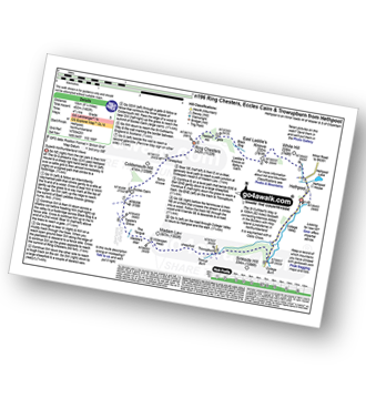
Route Summary:
Hethpool - The St Cuthbert's Way - White Hill (Hethpool) - East Laddie's Knowe - Laddie's Knowe or Betsy's Cairn - Black Bog (Haddon Hill) - Haddon Hill - Ring Chesters - Elsdonburn Farm - Elsdon Burn - The St Cuthbert's Way - Hethpool
|
Vital Statistics:
| Length: | 8.25 miles (13 km) |
| Ascent: | 1,483ft (452m) |
| Time: | 4½ hrs |
| Grade: | |
Route Summary:
Hethpool - The St Cuthbert's Way - White Hill (Hethpool) - East Laddie's Knowe - Laddie's Knowe or Betsy's Cairn - Black Bog (Haddon Hill) - Haddon Hill - Ring Chesters - Sheepfold - Eccles Cairn - England / Scotland Border - The Pennine Way - Tuppie's Grave - The Tongue - Maddie's Well - Madam Law - Wideopen Head - Trowup Burn - Trowupburn - College Valley - College Burn - Hethpool
|
Vital Statistics:
| Length: | 13.5 miles (21.5 km) |
| Ascent: | 2,504ft (763m) |
| Time: | 7½ hrs |
| Grade: | |

Route Summary:
Alwinton - Hosedon Burn - The Creel - Clennelstreet Farm - Clennell Street (Track) - Cross Dyke - Uplaw Knowe - Hare Sheds - Wholehope - Wholehope Knowe - Saughy Hill - Nettlehope Hill - Usway Burn - The Middle - Middle Hill - Fairhaugh - Hoseden Law - The Castles - Batailshiel Haugh - Shillmoor - The Knocks - Pass Peth - Alwinton
Not familiar with the area around TD8?
See these 30 nearest walks to UK Postcode TD8 on a google map
|
Vital Statistics:
| Length: | 4.75 miles (7.5 km) |
| Ascent: | 735ft (225m) |
| Time: | 2½ hrs |
| Grade: | |

|
Vital Statistics:
| Length: | 17 miles (27 km) |
| Ascent: | 3,463ft (1,055m) |
| Time: | 9½ hrs |
| Grade: | |
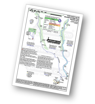
Route Summary:
Alwinton - River Alwin - Alwindale - Kidland Forest - Yoke Burn - Cushat Law - Bloodybush Edge - Uswayford Farm - Usway Burn - Nettlehope Hill - Flesh Shank - Wholehope - Clennell Street - Howedon Burn - Alwinton
|
Vital Statistics:
| Length: | 7 miles (11 km) |
| Ascent: | 2,022ft (616m) |
| Time: | 4½ hrs |
| Grade: | |

Route Summary:
Harthope Burn Valley - Hawsen Burn Parking Area - New Burn - Scald Hill - The Cheviot - Scald Hill - New Burn - Hawsen Burn Parking Area.
|
Vital Statistics:
| Length: | 9.5 miles (15.5 km) |
| Ascent: | 2,800ft (853m) |
| Time: | 6½ hrs |
| Grade: | |

Route Summary:
Harthope Burn Valley - Hawsen Burn Parking Area - New Burn - Scald Hill - The Cheviot - Cairn Hill (Scotsmans Cairn) - Harthope Burn - Comb Fell - Hedgehope Hill - Long Crags - Housey Crags - Hawsen Burn Parking Area.
|
Vital Statistics:
| Length: | 10.5 miles (17 km) |
| Ascent: | 2,614ft (797m) |
| Time: | 6½ hrs |
| Grade: | |

Route Summary:
Harthope Burn Valley - Cold Law - Broadhope Hill - Scald Hill - The Cheviot - The Pennine Way - Harthope Burn - Langleeford Hope - Langleeford - Harthope Burn Valley
|
Vital Statistics:
| Length: | 8.5 miles (13.5 km) |
| Ascent: | 2,114ft (644m) |
| Time: | 5½ hrs |
| Grade: | |

Route Summary:
Harthope Burn Valley - Hawsen Burn Parking Area - New Burn - Scald Hill - The Cheviot - Cairn Hill (Scotsmans Cairn) - Harthope Burn - Hrthope Linn - Langleeford Hope - Cat Loup - Ray Burn - Langleeford Farm - Hawsen Burn Parking Area.
|
Vital Statistics:
| Length: | 4 miles (6.75 km) |
| Ascent: | 732ft (223m) |
| Time: | 2½ hrs |
| Grade: | |

Route Summary:
Harbottle Castle - Drake Stone - West Wood - Harbottle Lake - Angryhaugh - Low Winton - River Coquet - Harbottle - Harbottle Castle
|
Vital Statistics:
| Length: | 4.5 miles (7 km) |
| Ascent: | 1,503ft (458m) |
| Time: | 3.25hrs |
| Grade: | |

Route Summary:
Linhope Farm - Linhope Burn - Dod Hill (Teviothead) - Bye Hill - Carlin Tooth (Teviothead) - Sunhope Hass - Linhope Burn - Elygrain Farm - Linhope Farm
|
Vital Statistics:
| Length: | 8.75 miles (14 km) |
| Ascent: | 2,793ft (851m) |
| Time: | 6 hrs |
| Grade: | |
Route Summary:
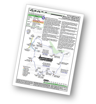
Linhope Farm - Lightning Hill - Wether Law (Teviothead) - Crummiecleuch Rig - Millstone Edge (Tudhope Hill) - Tudhope Hill - Little Tudhope Hill - Sunhope Hass - Carlin Tooth (Teviothead) - Bye Hill - Dod Hill (Teviothead) - Linhope Burn - Linhope Farm
|
Vital Statistics:
| Length: | 7.25 miles (11.5 km) |
| Ascent: | 2,009ft (612m) |
| Time: | 4.75hrs |
| Grade: | |
Route Summary:
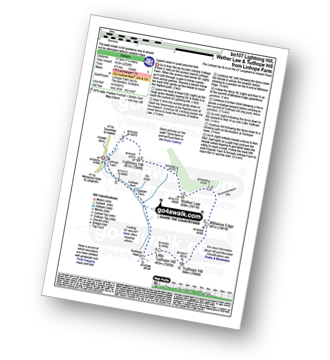
Linhope Farm - Lightning Hill - Wether Law (Teviothead) - Crummiecleuch Rig - Millstone Edge (Tudhope Hill) - Tudhope Hill - Little Tudhope Hill - Sunhope Hass - Elygrain Farm - Linhope Burn - Linhope Farm
|
Vital Statistics:
| Length: | 8.5 miles (13.5 km) |
| Ascent: | 945ft (288m) |
| Time: | 4 hrs |
| Grade: | |

Route Summary:
Hawkhope Car Park - Starsley Burn - Falstone Mine - Flastone Forest - Belling Burn - Goodwell Syke - Soney Gap - Plashetts Incline Jetty - Kielder Water - Benny Shanks Jetty - Pot Burn - Cock Soor - Whinny Hill - Belling Burn - The Belling - Bastle - Kielder Water Dam - Hawkhope Car Park
|
Vital Statistics:
| Length: | 3.75 miles (6 km) |
| Ascent: | 700ft (213m) |
| Time: | 2.25hrs |
| Grade: | |
Route Summary:
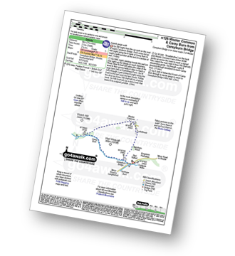
Careyburn Bridge - Carey Burn - Switcher Wood - Earlhillhead Farm - Wooler Common - Carey Burn - Careyburn Bridge
|
Vital Statistics:
| Length: | 4.5 miles (7 km) |
| Ascent: | 781ft (238m) |
| Time: | 2½ hrs |
| Grade: | |

Route Summary:
Careyburn Bridge - Carey Burn - Harthope Burn - Middleton Old Town - North Middleton - Colgate Mill - Colgate Water (Low Level Route) - Happy Valley - Broom Crook Plantation - Grimping Haugh - Skirl Naked - Careyburn Bridge
|
Vital Statistics:
| Length: | 5.75 miles (9 km) |
| Ascent: | 1,877ft (572m) |
| Time: | 4 hrs |
| Grade: | |
Route Summary:
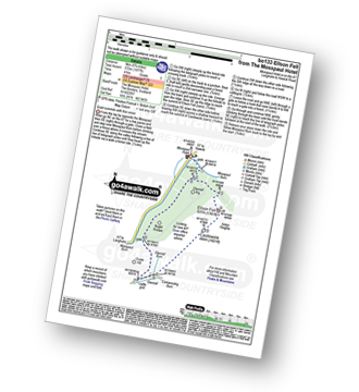
Mosspaul Hotel - Mosspaul Burn - Glenrief Rig - Ellson Fell - Castlewink - Glenrief Cottage - Bught Knowe - Glenrief Rig - Mosspaul Burn - Mosspaul Hotel
|
Vital Statistics:
| Length: | 7.5 miles (12 km) |
| Ascent: | 2,018ft (615m) |
| Time: | 4.75hrs |
| Grade: | |

Route Summary:
Mosspaul Hotel - Wisp Hill (Teviothead) - Ewenshope Fell - Ewes Doors - Ewelees Farm - Fiddleton Cottage - Bught Knowe - Glenrief Rig - Mosspaul Burn - Mosspaul Hotel
Not familiar with the area around TD8?
See these 30 nearest walks to UK Postcode TD8 on a google map


