UK Postcode EH36 - The 30 nearest easy-to-follow, circular walk route maps to you
The thirty nearest easy-to-follow, circular walk route maps to you in UK Postcode EH36 in Walk Grade Order
The UK cities, towns and villages in East Lothian, Scotland that have EH36 in their UK Postcode include:
• Gilchriston • Humbie •
Not familiar with the area around EH36?
See these 30 nearest walks to UK Postcode EH36 on a google map
   |
Vital Statistics:
| Length: | 8.75 miles (14 km) |
| Ascent: | 1,260ft (384m) |
| Time: | 4½ hrs |
| Grade: |  |

Route Summary:
Morebattle - The St Cuthbert's Way - Kale Water - Grubbit Law - Cushat End - Hownam Law - South Cote - Howgate - Heavyside - Gateshaw - Morebattle
|
Vital Statistics:
| Length: | 12.25 miles (19.5 km) |
| Ascent: | 3,305ft (1,007m) |
| Time: | 7.75hrs |
| Grade: |  |

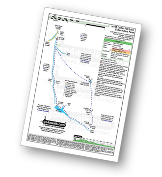
Route Summary:
Culter Allers Farm - Culter Fell - Moss Law - Holm Nick - Gathersnow Hill - Hillshaw Head - Coomb Dod - Dod Hill - Hudderstone - Lea Gill - Culter Water - Culter Allers Farm
|
Vital Statistics:
| Length: | 7.5 miles (12 km) |
| Ascent: | 1,699ft (518m) |
| Time: | 4½ hrs |
| Grade: | |
Route Summary:
Culter Allers Farm - Culter Fell - Moss Law - Holm Nick - Culter Water - Coulter Reservoir - Culter Waterhead - Culter Allers Farm
|
Vital Statistics:
| Length: | 7.5 miles (12 km) |
| Ascent: | 1,316ft (401m) |
| Time: | 4 hrs |
| Grade: | |

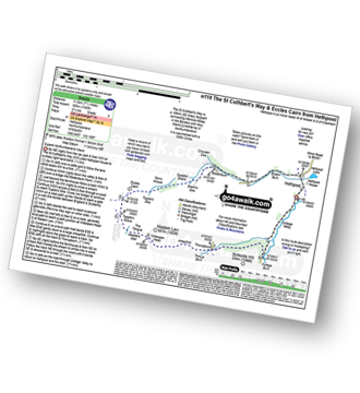
Route Summary:
Hethpool - The St Cuthbert's Way - White Hill (Hethpool) - East Laddie's Knowe - Laddie's Knowe or Betsy's Cairn - Black Bog (Haddon Hill) - Haddon Hill - Ring Chesters - Sheepfold - Eccles Cairn - England / Scotland Border - Elsdonnurn Farm - Elsdon Burn - The St Cuthbert's Way - Hethpool
|
Vital Statistics:
| Length: | 13.75 miles (22 km) |
| Ascent: | 2,665ft (812m) |
| Time: | 7.75hrs |
| Grade: | |

Route Summary:
Hethpool - The St Cuthbert's Way - Elsdon Burn - Elsdonburn Farm - Shank's Sike - Scaldhill Shank - Tom's Knowe - Tuppie's Sike - Eccles Cairn - England / Scotland Border - The Pennine Way - White Law - Steel Rig - Black Hag (Hethpool) - The Schil - Birnie Brae - Red Cribs - Mounthooly - Fleehope - Whitehall - College Valley - Hethpool
|
Vital Statistics:
| Length: | 16.5 miles (26.5 km) |
| Ascent: | 3,144ft (958m) |
| Time: | 9.25hrs |
| Grade: |  |

Route Summary:
Hethpool - College Valley - Whitehall - Fleehope - Mounthooly - Birnie Brae - The Pennine Way - Red Cribs - Auchope Cairn - Cairn Hill - The Cheviot - Scald Hill - Goldcleugh - Lambden Burn - Dunsdale - Coldburn - Southernknowe - Whitehall - Hethpool
|
Vital Statistics:
| Length: | 5 miles (8 km) |
| Ascent: | 1,021ft (311m) |
| Time: | 3 hrs |
| Grade: |  |

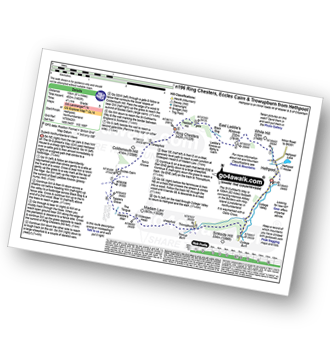
Route Summary:
Hethpool - The St Cuthbert's Way - White Hill (Hethpool) - East Laddie's Knowe - Laddie's Knowe or Betsy's Cairn - Black Bog (Haddon Hill) - Haddon Hill - Ring Chesters - Elsdonburn Farm - Elsdon Burn - The St Cuthbert's Way - Hethpool
|
Vital Statistics:
| Length: | 7.25 miles (11.5 km) |
| Ascent: | 1,165ft (355m) |
| Time: | 3.75hrs |
| Grade: |  |
Route Summary:
Hethpool - The St Cuthbert's Way - Elsdon Burn - Elsdonburn Farm - Shank's Sike - Scaldhill Shank - Tom's Knowe - Tuppie's Sike - Eccles Cairn - England / Scotland Border - The Pennine Way - Tuppie's Grave - The Tongue - Maddie's Well - Madam Law - Wideopen Head - Trowup Burn - Trowupburn - College Valley - College Burn - Hethpool
|
Vital Statistics:
| Length: | 8.25 miles (13 km) |
| Ascent: | 1,483ft (452m) |
| Time: | 4½ hrs |
| Grade: | |
Route Summary:
Hethpool - The St Cuthbert's Way - White Hill (Hethpool) - East Laddie's Knowe - Laddie's Knowe or Betsy's Cairn - Black Bog (Haddon Hill) - Haddon Hill - Ring Chesters - Sheepfold - Eccles Cairn - England / Scotland Border - The Pennine Way - Tuppie's Grave - The Tongue - Maddie's Well - Madam Law - Wideopen Head - Trowup Burn - Trowupburn - College Valley - College Burn - Hethpool
|
Vital Statistics:
| Length: | 8.25 miles (13 km) |
| Ascent: | 1,520ft (463m) |
| Time: | 4½ hrs |
| Grade: | |
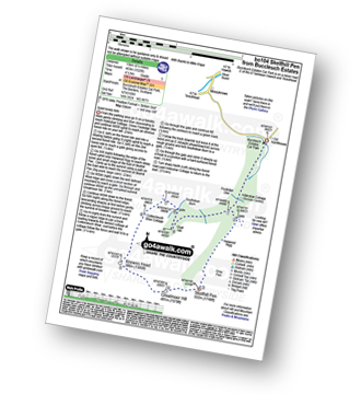
Route Summary:
Buccleuch Estates (Teviothead - Teviotdale) - Fouledge Syke - Alderybar Cottage - Harwood Rigg - Grey Pen - Skelfhill Pen - Greatmoor Hill - Knowes Head - Coltercleugh Shiel Cottage - Goat Hill - Buccleuch Estates (Teviothead).
|
Vital Statistics:
| Length: | 7 miles (11 km) |
| Ascent: | 1,408ft (429m) |
| Time: | 4 hrs |
| Grade: | |

Route Summary:
Towford Farm - Kale Water - Buchtrig Farm - Humblemoor Hill - Little Humblemoor - The Hows - Tronshaw Hill - Upper Chatto - Chatto - Towford Farm
|
Vital Statistics:
| Length: | 4 miles (6.5 km) |
| Ascent: | 1,057ft (322m) |
| Time: | 2.75hrs |
| Grade: | |

Route Summary:
Tow Ford - Dere Street - Woden Law - Langside Law - Buchtrig Farm - Kale Water - Tow Farm.
|
Vital Statistics:
| Length: | 10 miles (16 km) |
| Ascent: | 2,238ft (682m) |
| Time: | 6 hrs |
| Grade: |  |

Route Summary:
Tow Ford - Dere Street - Woden Law - Langside Law - Buchtrig Farm - Humblemoor Hill - Little Humblemoor - The Hows - Tronshaw Hill - Upper Chatto - Chatto - Towford Farm - Kale Water - Tow Farm.
|
Vital Statistics:
| Length: | 13.25 miles (21 km) |
| Ascent: | 2,586ft (788m) |
| Time: | 7.25hrs |
| Grade: | |

Route Summary:
Ettrick Water,Longhope Burn - Bught Hill - Bodesbeck Law - Nowtrig Head - Mid Rig (Bell Craig) - Salmongill Craig - Bald Craig - Bell Craig - Mirk Side - Andrewhinney Hill - Brockhope Head - Trowgrain Middle - Herman Law - Fala Grain - Back Beck - Brockhoperig - Ettrick Water
|
Vital Statistics:
| Length: | 4.5 miles (7 km) |
| Ascent: | 1,503ft (458m) |
| Time: | 3.25hrs |
| Grade: | |

Route Summary:
Linhope Farm - Linhope Burn - Dod Hill (Teviothead) - Bye Hill - Carlin Tooth (Teviothead) - Sunhope Hass - Linhope Burn - Elygrain Farm - Linhope Farm
Not familiar with the area around EH36?
See these 30 nearest walks to UK Postcode EH36 on a google map
|
Vital Statistics:
| Length: | 8.75 miles (14 km) |
| Ascent: | 2,793ft (851m) |
| Time: | 6 hrs |
| Grade: | |
Route Summary:
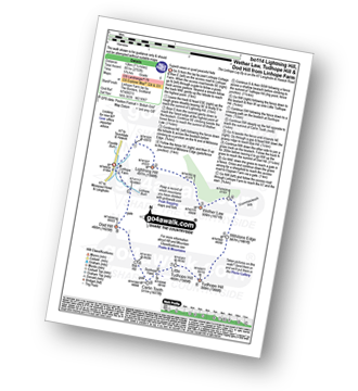
Linhope Farm - Lightning Hill - Wether Law (Teviothead) - Crummiecleuch Rig - Millstone Edge (Tudhope Hill) - Tudhope Hill - Little Tudhope Hill - Sunhope Hass - Carlin Tooth (Teviothead) - Bye Hill - Dod Hill (Teviothead) - Linhope Burn - Linhope Farm
|
Vital Statistics:
| Length: | 7.25 miles (11.5 km) |
| Ascent: | 2,009ft (612m) |
| Time: | 4.75hrs |
| Grade: | |
Route Summary:
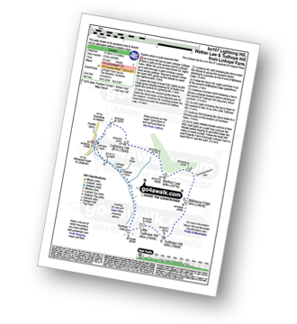
Linhope Farm - Lightning Hill - Wether Law (Teviothead) - Crummiecleuch Rig - Millstone Edge (Tudhope Hill) - Tudhope Hill - Little Tudhope Hill - Sunhope Hass - Elygrain Farm - Linhope Burn - Linhope Farm
|
Vital Statistics:
| Length: | 8.75 miles (14 km) |
| Ascent: | 3,236ft (986m) |
| Time: | 6½ hrs |
| Grade: | |
Route Summary:
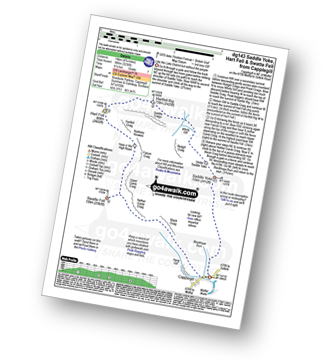
Capplegill - Blackhope Burn - Saddle Yoke - Under Saddle Yoke - Whirly Gill - Saddle Craigs - Harfell Rig - Hart Fell (Moffat) - Hartfell Craig - Falcon Craig - Upper Comb Craig - Swatte Fell - Nether Comb Craig - Black Craig - Hang Burn - Hang Gill - Capplegill
|
Vital Statistics:
| Length: | 5.5 miles (8.5 km) |
| Ascent: | 620ft (189m) |
| Time: | 2.75hrs |
| Grade: | |
Route Summary:
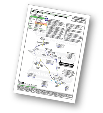
Doddington Bridge - Quarry Hill - Weetwood Hill - Broomy Knowe - Shepherds House - Dod Law - Doddington Moor - Doddington - Milfield Plain - River Till - Doddington Bridge
|
Vital Statistics:
| Length: | 3.25 miles (5 km) |
| Ascent: | 525ft (160m) |
| Time: | 1.75hrs |
| Grade: |  |
Route Summary:
Wooler - The St Cuthbert's Way - Waud House - Kenterdale Hill - Wooler Common and Woodland Park - Wooler
|
Vital Statistics:
| Length: | 4.75 miles (7.5 km) |
| Ascent: | 985ft (300m) |
| Time: | 2.75hrs |
| Grade: | |
Route Summary:
Wooler - Gallowlaw Gallowlaw Hill - Humbleton - Humbleton Hill - Brown's Law - Wooler Common And Woodland Park - Wooler
|
Vital Statistics:
| Length: | 6.5 miles (10.5 km) |
| Ascent: | 240ft (73m) |
| Time: | 2.75hrs |
| Grade: | |
Route Summary:
Wooler - Gallowlaw Gallowlaw Hill - Low Humbleton - Bowchester - The River Glen - Bridge End - Humbleton Burn Milfield Plain - St Cuthbert's Bridge - Turvelaws Farm - Wooler
|
Vital Statistics:
| Length: | 5.75 miles (9 km) |
| Ascent: | 1,214ft (370m) |
| Time: | 3½ hrs |
| Grade: | |
Route Summary:
Wooler - Gallowlaw Gallowlaw Hill - Humbleton - Humbleton Hill - Brown's Law - Wooler Common and Woodland Park - The St Cuthbert's Way - Kenterdale Hill - Waud House - Wooler
|
Vital Statistics:
| Length: | 7.5 miles (12 km) |
| Ascent: | 1,257ft (383m) |
| Time: | 4½ hrs |
| Grade: | |

Route Summary:
Wooler - The St Cuthbert's Way - Waud House - Kenterdale Hill - Wooler Common - Switcher Wood - Earlhillhead Farm - Carey Burn - Careyburn Bridge - Harthope Burn - Colgate Water (High Level Route) - Happy Valley - Middleton Old Town - North Middleton - Colgate Mill - Colgate Water - Earle Mill - Wooler Water - Wooler
|
Vital Statistics:
| Length: | 8.5 miles (13.5 km) |
| Ascent: | 1,093ft (333m) |
| Time: | 4.25hrs |
| Grade: | |

Route Summary:
Wooler - The St Cuthbert's Way - Weetwood Bank - Weetwood Moor - River Till - Weetwood Bridge - Weetwood Hall - Weetwood Hill - Broomy Knowe - Shepherds House - Dod Law - Doddington Moor - Doddington - Milfield Plain - Doddington Bridge - Turvelaws Farm - Wooler
|
Vital Statistics:
| Length: | 10.75 miles (17 km) |
| Ascent: | 1,746ft (532m) |
| Time: | 5.75hrs |
| Grade: | |

Route Summary:
Wooler - The St Cuthbert's Way - Waud House - Kenterdale Hill - Wooler Common - Carey Burn - Broadstruthers Burn - Commonburn House - Wackerage Cairn - Tom Tallon's Crag - The St Cuthbert's Way - Gleadscleugh - Akeld Burn - Humbleton - Gallowlaw - Wooler
|
Vital Statistics:
| Length: | 10.25 miles (16.5 km) |
| Ascent: | 1,182ft (360m) |
| Time: | 5 hrs |
| Grade: | |

Route Summary:
Wooler - The St Cuthbert's Way - Weetwood Bank - Weetwood Moor - River Till - Weetwood Bridge - Weetwood Hall - Weetwood Hill - Broomy Knowe - Shepherds House - Dod Law (Doddington Moor) - Doddington Moor - Doddington - River Till - St Cuthbert's Bridge - Milfield Plain - River Glen - Bridge End - Bowchester - Low Humbleton - Gallowlaw Hill - Gallowlaw - Wooler
|
Vital Statistics:
| Length: | 6.5 miles (10.5 km) |
| Ascent: | 1,043ft (318m) |
| Time: | 3½ hrs |
| Grade: | |

Route Summary:
Wooler - The St Cuthbert's Way - Waud House - Kenterdale Hill - Wooler Common - Switcher Wood - Earlhillhead Farm - Carey Burn - Careyburn Bridge - Harthope Burn - Colgate Water (Low Level Route) - Skirl Naked - Grimping Haugh - Broom Crook Plantation - Happy Valley - Careyburn Bridge - Colgate Mill - Earle Mill - Wooler Water - Wooler
|
Vital Statistics:
| Length: | 9.5 miles (15.5 km) |
| Ascent: | 2,800ft (853m) |
| Time: | 6½ hrs |
| Grade: | |

Route Summary:
Harthope Burn Valley - Hawsen Burn Parking Area - New Burn - Scald Hill - The Cheviot - Cairn Hill (Scotsmans Cairn) - Harthope Burn - Comb Fell - Hedgehope Hill - Long Crags - Housey Crags - Hawsen Burn Parking Area.
|
Vital Statistics:
| Length: | 7 miles (11 km) |
| Ascent: | 2,022ft (616m) |
| Time: | 4½ hrs |
| Grade: | |

Route Summary:
Harthope Burn Valley - Hawsen Burn Parking Area - New Burn - Scald Hill - The Cheviot - Scald Hill - New Burn - Hawsen Burn Parking Area.
Not familiar with the area around EH36?
See these 30 nearest walks to UK Postcode EH36 on a google map


