UK Postcode DE6 - The 30 nearest easy-to-follow, circular walk route maps to you
The thirty nearest easy-to-follow, circular walk route maps to you in UK Postcode DE6 in Walk Grade Order
The UK cities, towns and villages in Derbyshire, England that have DE6 in their UK Postcode include:
• Alkmonton • Alsop en le Dale • Alstonefield • Ashbourne • Atlow • Ballidon • Biggin • Blore • Boylestone • Bradbourne • Bradley • Brailsford • Clifton • Coton in the Clay • Doveridge • Draycott in the Clay • Edlaston • Ednaston • Ellastone • Fenny Bentley • Great Cubley • Hanging Bridge • Hognaston • Hollington • Hulland • Ilam • Kirk Ireton • Kirk Langley • Kniveton • Langley Green • Lees • Longford • Longlane • Mapleton • Marston Montgomery • Mayfield • Mercaston • Mugginton • Norbury • Osmaston • Parwich • Radbourne • Rodsley • Roston • Scropton • Shirley • Snelston • Somersal Herbert • Stanton • Sudbury • Sutton on the Hill • Swinscoe • Thorpe • Thurvaston • Tissington • Trusley • Waldley • Wardgate • Weston Underwood • Wetton • Wootton • Wyaston • Yeaveley •
Not familiar with the area around DE6?
See these 30 nearest walks to UK Postcode DE6 on a google map
   |
Vital Statistics:
| Length: | 6.75 miles (11 km) |
| Ascent: | 876ft (267m) |
| Time: | 3½ hrs |
| Grade: |  |
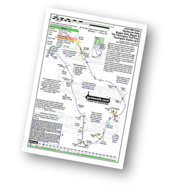
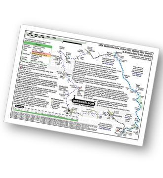
Route Summary:
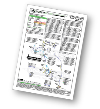
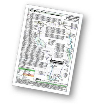
Mappleton Lane (Ashbourne) - The Tissington Trail - Thorpe - The Limestone Way - Coldwall Bridge - River Dove - Big Peg's Wood - Little Peg's Wood - Littlepark Farm - Mappleton (aka Mapleton) - Callow Top - Mappleton Lane (Ashbourne)
|
Vital Statistics:
| Length: | 12.25 miles (19.5 km) |
| Ascent: | 1,930ft (588m) |
| Time: | 6½ hrs |
| Grade: |  |

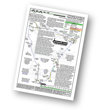
Route Summary:
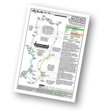
Mappleton Lane (Ashbourne) - The Tissington Trail - Thorpe - Pike House - Bostern Grange Farm - Hanson Grange - The Nabs - Dove Dale - Dove Holes - Taylors Wood - Pickering Rock - Ilam Rock - Shaplow Dale - Lin Dale - Thorpe Cloud - Thorpe Mill Farm - The Limestone Way - Coldwall Bridge - River Dove - Big Peg's Wood - Little Peg's Wood - Littlepark Farm - Mappleton (aka Mapleton) - Callow Top - Mappleton Lane (Ashbourne)
|
Vital Statistics:
| Length: | 6.5 miles (10.5 km) |
| Ascent: | 745ft (227m) |
| Time: | 3.25hrs |
| Grade: |  |

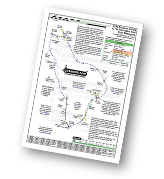
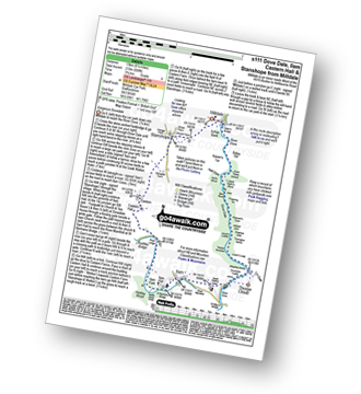
Route Summary:
Mappleton (aka Mapleton) - Okeover Bridge - Okeover Hall - Okeover Park - Cowclose Wood - Martin Hill Farm - Woodhouses Farm - Blore - Blore Pastures - Ilam - River Manifold - The Manifold Trail - Fishpond Wood - River Dove - Coldwall Bridge - Big Peg's Wood - Little Peg's Wood - Littlepark Farm - Okeover Bridge - Mappleton (aka Mapleton)
|
Vital Statistics:
| Length: | 4 miles (6.5 km) |
| Ascent: | 508ft (155m) |
| Time: | 2 hrs |
| Grade: |  |

Route Summary:
Fenny Bentley - Lees Farm - Darfield Plantation - Tissington - The Tissington Trail - Thorpe Station - Fenny Bentley
|
Vital Statistics:
| Length: | 8 miles (12.5 km) |
| Ascent: | 1,010ft (305m) |
| Time: | 4 hrs |
| Grade: | |
Route Summary:
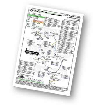
Kniveton - Whitelands - Wigber Low - Bradbourne Mill - Bletch Brook - Sitterlow Farm - Parwich - Ballidon - Bradbourne - Newhouse Farm - Kniveton
|
Vital Statistics:
| Length: | 9.75 miles (15.5 km) |
| Ascent: | 735ft (224m) |
| Time: | 5.25hrs |
| Grade: | |
Route Summary:
Thorpe - The Tissington Trail - Lin Dale - Dove Dale - The River Dove - Stepping Stones - Lover's Leap - Tissington Spires - Shaplow Dale - Dove Holes - Milldale - Mill Dale - Alsop en le Dale - The Tissington Trail - Tissington - Thorpe
|
Vital Statistics:
| Length: | 6 miles (9.5 km) |
| Ascent: | 918ft (280m) |
| Time: | 3.25hrs |
| Grade: | |

Route Summary:
Swinscoe - Hillend Farm - Feenie Lee - Blore - The Limestone Way - Coldwall Bridge - River Dove - Big Peg's Wood - Little Peg's Wood - Littlepark Farm - Mappleton (aka Mapleton) - Okeover Hall - Okeover Park - Cowclose Wood - Martin Hill - Woodhouse Farm - Swinscoe
|
Vital Statistics:
| Length: | 6.25 miles (10 km) |
| Ascent: | 941ft (287m) |
| Time: | 3.25hrs |
| Grade: | |
Route Summary:
Tissington - Newton Grange - The Tissington Trail - Alsop en le Dale Station - Alsop en le Dale - Flaxdale Holding - Parwich - Bletch Brook - Higher Flats - Tissington
|
Vital Statistics:
| Length: | 15.5 miles (24.5 km) |
| Ascent: | 1,742ft (531m) |
| Time: | 7.25hrs |
| Grade: |  |
Route Summary:
Tissington - The Tissington Trail - Thorpe Station - Thorpe - Pike House - Thorpe Pasture - Bostern Grange Farm - Milldale - River Dove - Mill Dale - Lode Mill Bridge - Coldeaton Bridge - Wolfscote Dale - Biggin Dale - Biggin - The Tissington Trail - Alsop en le Dale Station - Tissington
|
Vital Statistics:
| Length: | 8.5 miles (13.5 km) |
| Ascent: | 1,099ft (335m) |
| Time: | 4.25hrs |
| Grade: |  |

Route Summary:
Tissington - The Tissington Trail - Alsop en le Dale Station - Oxdales Farm - Eaton Dale - Eatondale Wood - Flaxdale Holding - Parwich - Bletch Brook - Higher Flats - Tissington
|
Vital Statistics:
| Length: | 9 miles (14.5 km) |
| Ascent: | 1,453ft (446m) |
| Time: | 4.75hrs |
| Grade: | |
Route Summary:
Tissington - The Tissington Trail - Thorpe Station - Thorpe - Pike House - Thorpe Pasture - Bostern Grange Farm - Alsop en le Dale Station - Parwich - The Limestone Way - Tissington
|
Vital Statistics:
| Length: | 7.25 miles (12.5 km) |
| Ascent: | 1,056ft (322m) |
| Time: | 3.75hrs |
| Grade: | |
Route Summary:
Tissington - The Tissington Trail - Thorpe Station - Thorpe - Pike House - Thorpe Pasture - Bostern Grange Farm - Alsop en le Dale Station - Tissington
|
Vital Statistics:
| Length: | 7.25 miles (12.5 km) |
| Ascent: | 1,007ft (307m) |
| Time: | 4 hrs |
| Grade: | |

Route Summary:
Tissington - The Tissington Trail - Thorpe Station - Fenny Bentley - Woodeaves Mill - Woodeaves Farm - Lea Hall - Lee Cottage Farm - Bletch Book - Sittlerlow Farm - Parwich - The Limestone Way - Bletch Brook - The Tissington Trail - Tissington
|
Vital Statistics:
| Length: | 6.25 miles (10 km) |
| Ascent: | 623ft (190m) |
| Time: | 3 hrs |
| Grade: | |
Route Summary:
Dove Dale - The River Dove - Stepping Stones - Lover's Leap - Tissington Spires - Shaplow Dale,Natural Arch - Raynard's Cave - Upper Taylor's Wood - Dove Holes - Viator's Bridge - Milldale - Achas Bank - Hall Dale - Hurt's Wood - Ilam Rock - Jacob's Ladder (Dove Dale) - Dove Dale Wood - Dovedale Castle - Dove Dale
|
Vital Statistics:
| Length: | 8.25 miles (13 km) |
| Ascent: | 843ft (257m) |
| Time: | 3.75hrs |
| Grade: | |

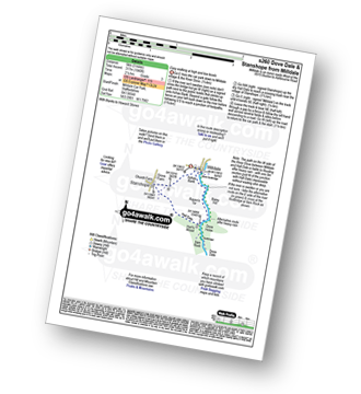
Route Summary:
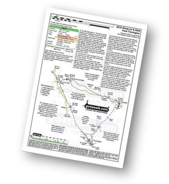
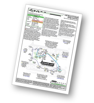
Carsington Water Visitors Centre - Carsington Water Dam - Millfields - 'Wooden' House - Upperfield Farm - Hopton - Hopton Hall - Carsington - Sheepwash - Carsington Wildlife Conservation Centre - Carsington Water Visitors Centre
Not familiar with the area around DE6?
See these 30 nearest walks to UK Postcode DE6 on a google map
|
Vital Statistics:
| Length: | 10.25 miles (16.5 km) |
| Ascent: | 1,969ft (600m) |
| Time: | 2.75hrs |
| Grade: | |

Route Summary:
Ilam - The Manifold Trail - Ilam Country Park - River Manifold - Rushley - Slade House - Throwley Moor - Lee House Farm - Manifold Valley - River Hamps - Saucefield Farm - Grindon - Weag's Bridge - Beeston Tor Farm - The Manifold Trail - Throwley Hall Farm - Rushley - Ilam Country Park - Ilam
|
Vital Statistics:
| Length: | 10.25 miles (16.5 km) |
| Ascent: | 1,486ft (453m) |
| Time: | 5.25hrs |
| Grade: | |

Route Summary:
Ilam - The Manifold Trail - Ilam Country Park - River Manifold - Castern Hall - Castern Wood Nature Reserve - Weag's Bridge - The Manifold Way - The River Hamps - Manifold Valley - Lee House Farm - Throwley Moor - Slade House - Rushley - Ilam Country Park - Ilam
|
Vital Statistics:
| Length: | 9.75 miles (15.5 km) |
| Ascent: | 2,146ft (654m) |
| Time: | 5.75hrs |
| Grade: | |
Route Summary:
Ilam - Ilam Country Park - River Manifold - Castern Hall - Castern Wood Nature Reserve - Wetton Low - Wetton - Alstonefield - Milldale - Achas Bank - Raven's Tor - Hall Dale - Dove Dale Wood - Air Cottage - Ilam Tops - Ilamtops Farm - Ilam
|
Vital Statistics:
| Length: | 4.75 miles (7.5 km) |
| Ascent: | 754ft (230m) |
| Time: | 2½ hrs |
| Grade: | |
Route Summary:
Ilam - Ilam Country Park - River Manifold - Lower Dove Dale - Upper Musden - Hazelton Clump - Blore - Coldwall Farm - The Limestone Way - Coldwall Bridge - The Manifold Trail - River Dove - Fishpond Wood - River Manifold - Ilam
|
Vital Statistics:
| Length: | 7.25 miles (11.5 km) |
| Ascent: | 1,080ft (329m) |
| Time: | 3.75hrs |
| Grade: | |
Route Summary:
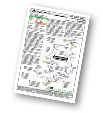
Brassington - The Limestone Way - Rainster Rocks - Longcliffe - Aldwark - Grangemill - The Limestone Way - Grange Mill Quarry - Harboro' Farm - Harboro' Rocks - Bee Nest Mine - Brassington
|
Vital Statistics:
| Length: | 9.5 miles (15.5 km) |
| Ascent: | 705ft (215m) |
| Time: | 1.25hrs |
| Grade: | |
Route Summary:
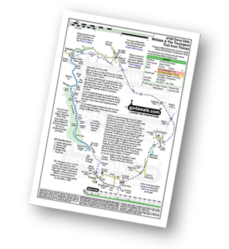
Alsop en le Dale Station - New Hanson Grange - Milldale - River Dove - Mill Dale - Lode Mill Bridge - Coldeaton Bridge - Iron Tors - Gipsy Bank - Drabber Tor - Peasland Rocks - Wolfscote Dale - Biggin Dale - Furny Bottom - Dale End (Heathcote) - Biggin - The Tissington Trail - Alsop en le Dale Station
|
Vital Statistics:
| Length: | 11.5 miles (18.5 km) |
| Ascent: | 1,572ft (479m) |
| Time: | 5.75hrs |
| Grade: | |
Route Summary:
Milldale - Mill Dale - River Dove - Coldeaton Bridge - Gipsy Bank - Peasland Rocks - Wolfscote Dale - Frank-i-the=Ricks Bridge - Beresford Dale - Barracks Farm - Harecops - Acton Moor - Back of Ecton - Ecton Hill - Cantrell's House - Wetton Hill - Wetton Hill (West Top) - Wetton - Alstonefield - Milldale
|
Vital Statistics:
| Length: | 6.75 miles (11 km) |
| Ascent: | 623ft (190m) |
| Time: | 3.25hrs |
| Grade: | |

Route Summary:
Milldale - Dove Dale - Viator's Bridge - River Dove - Dove Holes - Upper Taylor's Wood - Pickering Tor,Raynard's Cave - Natural Arch - Sharplow Dale - Jacob's Ladder (Dove Dale) - Lover's Leap - Twelve Apostles - Dove Dale Castle - Thorpe Cloud - Ilam - Ilamtops Farm - Ilam Tops - Ilam Rock - Hall Dale - Raven's Tor - Achas Bank - Milldale
|
Vital Statistics:
| Length: | 8.25 miles (13 km) |
| Ascent: | 689ft (210m) |
| Time: | 3.75hrs |
| Grade: | |
Route Summary:
Milldale - Dove Dale - Viator's Bridge - River Dove - Dove Holes - Upper Taylor's Wood - Pickering Tor,Raynard's Cave - Natural Arch - Sharplow Dale - Jacob's Ladder (Dove Dale) - Lover's Leap - Twelve Apostles - Dove Dale Castle - Thorpe Cloud - Ilam - Ilam Country Park - St Bartram's Bridge - River Manifold - Battle Stone Cross - Ilam Wood - River Lodge - Castern Hall - Castern Farm - Stanshope - Milldale
|
Vital Statistics:
| Length: | 3 miles (5 km) |
| Ascent: | 1,040ft (317m) |
| Time: | 2.25hrs |
| Grade: | |
Route Summary:
Milldale - Achas Bank - Dove Dale - The River Dove - Raven's Tor - Hall Dale - Ilam Rock - Hurt's Wood - Stanshope - Church Farm - Milldale
|
Vital Statistics:
| Length: | 7.25 miles (11.5 km) |
| Ascent: | 1,302ft (397m) |
| Time: | 4 hrs |
| Grade: | |

Route Summary:
Milldale - River Dove - Alstonefield - Wetton - Wetton Low - Castern Wood Nature Reserve - Damgate Farm - Hall Dale - Dove Dale - Achas Bank - Milldale
|
Vital Statistics:
| Length: | 11.5 miles (18 km) |
| Ascent: | 1,267ft (386m) |
| Time: | 5½ hrs |
| Grade: | |

Route Summary:
Waterhouses - Waterfall Cross - Martins Low - River Hamps - Ford - Onecote - Grindonmoor Gate - Grindon Moor (Grindon Moor) - Grindon - Lee House - The Manifold Way - Waterhouses
|
Vital Statistics:
| Length: | 8.25 miles (13 km) |
| Ascent: | 1,588ft (484m) |
| Time: | 4½ hrs |
| Grade: | |

Route Summary:
Waterhouses - The Manifold Way - The River Hamps - Sparrowlee Bridge - Lee House - Hell Hole - Old Soles Wood - Soles Coppice - The River Manifold - Weag's Bridge - Beeston Tor Farm - Throwley Hall Farm - Throwley Cottage - Farwall Farm - The Manifold Way - Waterhouses
|
Vital Statistics:
| Length: | 5.5 miles (9 km) |
| Ascent: | 1,615ft (492m) |
| Time: | 3.75hrs |
| Grade: | |

Route Summary:
Alstonefield - Alstonefield Youth Hostel - Overdale - Gipsy Bank - Wolfescote Dale - Coldeaton Bridge - Mill Dale - Milldale - Dove Dale - Achas Bank - Ilam Rock - Dovedale - Hall Dale - Stanshope - Dale Bottome - Alstonefield.
|
Vital Statistics:
| Length: | 5.5 miles (9 km) |
| Ascent: | 426ft (130m) |
| Time: | 2½ hrs |
| Grade: | |

Route Summary:
Alstonefield - Overdale - Coldeaton Bridge - River Dove - Coldeaton Bridge - Iron Tors - Gipsy Bank - Drabber Tor - Caves - Peasland Tor - Wolfscote Dale - Beresford Dale - Narrow Dale - The Rakes - Alstonefield
Not familiar with the area around DE6?
See these 30 nearest walks to UK Postcode DE6 on a google map


