UK Postcode CV6 - The 30 nearest easy-to-follow, circular walk route maps to you
The thirty nearest easy-to-follow, circular walk route maps to you in UK Postcode CV6 in Walk Grade Order
The UK cities, towns and villages in West Midlands, England that have CV6 in their UK Postcode include:
• Court House Green • Foleshill • Great Heath • Keresley • Little Heath • Longford • Radford •
Not familiar with the area around CV6?
See these 30 nearest walks to UK Postcode CV6 on a google map
   |
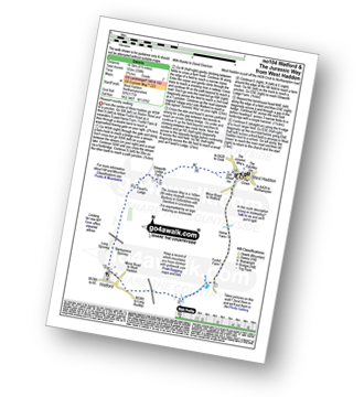
Vital Statistics:
| Length: | 5.75 miles (9 km) |
| Ascent: | 226ft (69m) |
| Time: | 2½ hrs |
| Grade: |  |

Route Summary:
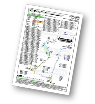
Watford - The Jurassic Way - Barleypiece Spinney - Long Spinney - Watford Covert - Flavell's Lodge - Silsworth Lodge Farm - Cherry Lodge - Watford
|
Vital Statistics:
| Length: | 7 miles (11 km) |
| Ascent: | 151ft (46m) |
| Time: | 2.75hrs |
| Grade: | |

Route Summary:
Stratford-upon-Avon - Tramway - River Stour - Clifford Chambers - The Greenway - River Avon - Stratford-upon-Avon
|
Vital Statistics:
| Length: | 6.5 miles (10.5 km) |
| Ascent: | 338ft (103m) |
| Time: | 2.75hrs |
| Grade: | |
Route Summary:
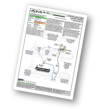
West Haddon - Foxhill Farm - Watford - The Jurassic Way - Barleypiece Spinney - Long Spinney - Flavell's Lodge - Silsworth Lodge Farm - West Haddon
|
Vital Statistics:
| Length: | 5.25 miles (8.5 km) |
| Ascent: | 292ft (89m) |
| Time: | 2.25hrs |
| Grade: | |
|
Vital Statistics:
| Length: | 5.5 miles (9 km) |
| Ascent: | 499ft (152m) |
| Time: | 2½ hrs |
| Grade: |  |

|
Vital Statistics:
| Length: | 7 miles (11 km) |
| Ascent: | 771ft (235m) |
| Time: | 3.25hrs |
| Grade: |  |
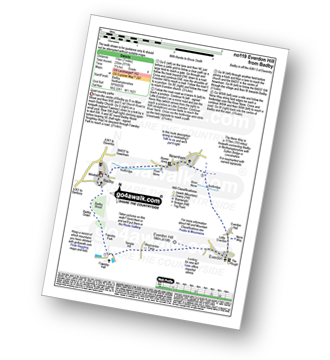
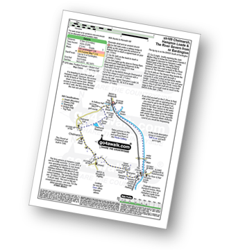
Route Summary:
Badby - Knightley Way - Badby Wood - Badby Down - Fawsley Hall - Everdon Hill - Everdon - Little Everdon - The Nene Way - River Nene - Newnham - Badby
|
Vital Statistics:
| Length: | 3.5 miles (5.5 km) |
| Ascent: | 289ft (88m) |
| Time: | 1.75hrs |
| Grade: |  |

Route Summary:
Conkers Discovery Centre - Swadlincote - Conkers Waterside - Ashby Woulds Heritage Trail - Donisthorpe - Donisthorpe Woodland Park - Ashby De La Zouch Canal - Moira Lock - Moira Furnace Museum - Moira - Sarah's Wood - Conkers Waterside - Conkers Discovery Centre - Swadlincote.
|
Vital Statistics:
| Length: | 5 miles (8 km) |
| Ascent: | 345ft (105m) |
| Time: | 2.25hrs |
| Grade: | |
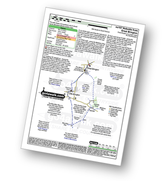
Route Summary:
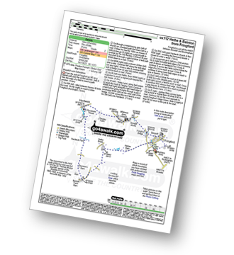
Great Brington - Nobottle Wood - The Midshires Way - Nobottle - The Macmillan Way - Little Brington - Great Brington
|
Vital Statistics:
| Length: | 8.5 miles (13.5 km) |
| Ascent: | 246ft (75m) |
| Time: | 3½ hrs |
| Grade: | |
|
Vital Statistics:
| Length: | 10.25 miles (16.5 km) |
| Ascent: | 463ft (141m) |
| Time: | 4.25hrs |
| Grade: | |

Route Summary:
Moreton-in-Marsh - The Mornarch's Way - Upper Fields Farm - Longborough - Donnington - Broadwell - Quinmoor Far - River Evenlode - Evenlode - Codicote Farm - Moreton-in-Marsh
|
Vital Statistics:
| Length: | 6.25 miles (10 km) |
| Ascent: | 670ft (204m) |
| Time: | 3 hrs |
| Grade: | |
Route Summary:
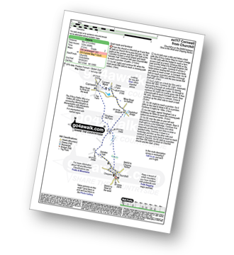
Adlestrop - The Macmillan Way - Chastleton - Chastleton House - Chastleton Barrow Iron Age Fort - Cornwell - Adlestrop
|
Vital Statistics:
| Length: | 3.75 miles (6 km) |
| Ascent: | 394ft (120m) |
| Time: | 1.75hrs |
| Grade: | |
Route Summary:
Adlestrop - The Macmillan Way - Chastleton - Chastleton House - Chastleton Barrow Iron Age Fort - Long Drive - Adlestrop
|
Vital Statistics:
| Length: | 9 miles (14.5 km) |
| Ascent: | 801ft (244m) |
| Time: | 4.25hrs |
| Grade: | |

Route Summary:
Adlestrop - The Macmillan Way - Chastleton - Chastleton House - Chastleton Barrow Iron Age Fort - Cornwell - Daylesford - The Macmillan Way - Lower Oddington - Adlestrop Park - Adlestrop
|
Vital Statistics:
| Length: | 8.25 miles (13 km) |
| Ascent: | 696ft (212m) |
| Time: | 3.75hrs |
| Grade: | |

|
Vital Statistics:
| Length: | 5.25 miles (8.5 km) |
| Ascent: | 177ft (54m) |
| Time: | 2.25hrs |
| Grade: | |
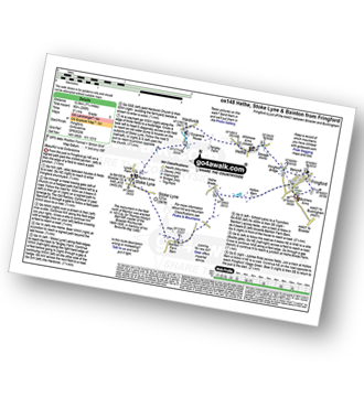
Route Summary:
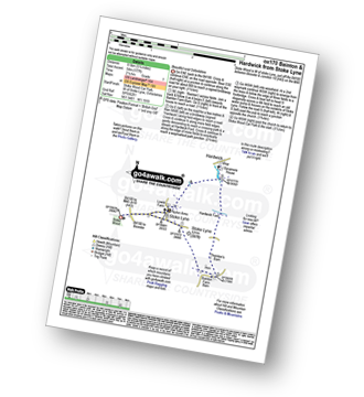
Stoke Wood - Stoke Lyne - Bainton - Hardwick Ford - Hardwick - Stoke Bushes - Stoke Lyne - Stoke Wood
Not familiar with the area around CV6?
See these 30 nearest walks to UK Postcode CV6 on a google map
|
Vital Statistics:
| Length: | 6 miles (9.5 km) |
| Ascent: | 508ft (155m) |
| Time: | 2½ hrs |
| Grade: | |

Route Summary:
Stow-on-the-Wold - The Monarch's Way - Broadwell - Donnington - Battle of Stow Memorial - The Gloucestershire Way - Upper Swell - Stow-on-the-Wold
|
Vital Statistics:
| Length: | 5.5 miles (9 km) |
| Ascent: | 400ft (122m) |
| Time: | 2½ hrs |
| Grade: | |
Route Summary:
Churchill - Sarsden Halt. Kingham Hill Farm - Cornwell - Swailsford Bridge - Churchill
|
Vital Statistics:
| Length: | 9.75 miles (15 km) |
| Ascent: | 555ft (169m) |
| Time: | 4 hrs |
| Grade: | |

Route Summary:
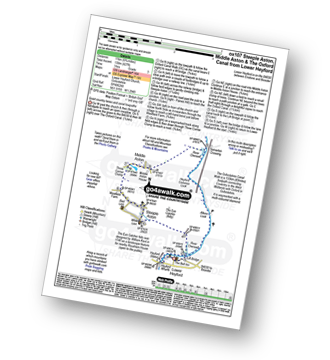
Lower Heyford - Heyford Wharfe - The Oxford Canal - The Eye Catcher - Steeple Aston - Three Corner Clump - Middle Aston - Warren Lodge - Hendon Farm - North Aston - The Manor - River Cherwell - Somerton - The Oxfordshire Canal Walk - The Oxford Canal - Somerton Crossing - Heyford Common Lock - Allens Lock - Lower Heyford
|
Vital Statistics:
| Length: | 6.75 miles (11 km) |
| Ascent: | 427ft (130m) |
| Time: | 3 hrs |
| Grade: | |
Route Summary:
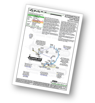
Lower Heyford - Heyford Wharfe - The Oxford Canal - The Eye Catcher - Steeple Aston - Three Corner Clump - Middle Aston - River Cherwell - Somerton Crossing - The Oxfordshire Canal Walk - The Oxford Canal - Heyford Common Lock - Allens Lock - Lower Heyford
|
Vital Statistics:
| Length: | 4.75 miles (7.5 km) |
| Ascent: | 368ft (112m) |
| Time: | 2.25hrs |
| Grade: | |
Route Summary:
Lower Heyford - Heyford Wharfe - The Oxford Canal - Steeple Aston - The Eye Catcher (Folly) - River Cherwell - The Oxfordshire Canal Walk - The Oxford Canal - Allens Lock - Lower Heyford
|
Vital Statistics:
| Length: | 6.75 miles (10 km) |
| Ascent: | 256ft (78m) |
| Time: | 2.75hrs |
| Grade: | |
|
Vital Statistics:
| Length: | 7.75 miles (12.5 km) |
| Ascent: | 295ft (90m) |
| Time: | 3.25hrs |
| Grade: | |
|
Vital Statistics:
| Length: | 5.25 miles (8.5 km) |
| Ascent: | 532ft (162m) |
| Time: | 2½ hrs |
| Grade: | |
Route Summary:
Eardington - Dinney Barn - The Jack Mytton Way - Chelmarsh Reservoir - Chelmarsh - Hampton - The Jack Mytton Way - The Severn Valley Railway - Hampton Loade - The Hampton Loade Ferry - The River Severn - The Severn Way - Eardington
|
Vital Statistics:
| Length: | 8.5 miles (13.5 km) |
| Ascent: | 951ft (290m) |
| Time: | 4 hrs |
| Grade: | |

Route Summary:
Winchcombe - River Isbourne - The Cotswold Way - Salter's Lane - Hailes Abbey - North Farmcote - Lynes Barn - Campden Lane (Track) - Deadmanbury Gate - Wardens' Way - Salt Way - The Warren - Parks Farm - Sudeley Lodge - Sudeley Castle - Winchcombe
|
Vital Statistics:
| Length: | 8.75 miles (14 km) |
| Ascent: | 574ft (175m) |
| Time: | 3.75hrs |
| Grade: | |

Route Summary:
Charlbury - The Oxfordshire Way - Dean Grove - Coldron Mill - Spelsbury - Taston - Taston Village Cross - The Wychwood Way - Inotts Clump - Shilcott Wood - Ditchley Park - Charlbury
|
Vital Statistics:
| Length: | 9.5 miles (15.5 km) |
| Ascent: | 1,132ft (345m) |
| Time: | 4.75hrs |
| Grade: |  |
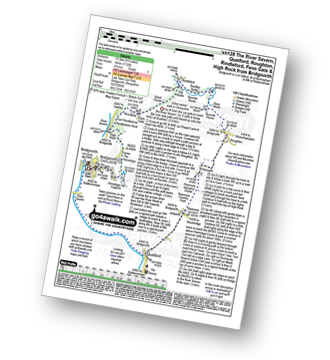
Route Summary:
Bridgnorth - The River Severn - Quatford - Stanmore Country Park - Hoccum - Roughton - Burcote House - River Worfe - Soudley Rocks - Rindleford - Batch House - Fenn Gate - Woodside - High Rock - Caves - The Hermitage - Hermitage Hill Coppice - Bridgnorth
|
Vital Statistics:
| Length: | 10 miles (16 km) |
| Ascent: | 722ft (220m) |
| Time: | 4.25hrs |
| Grade: | |

Route Summary:
Bridgnorth - Lower Town - River Severn - The Severn Way - Apley Forge - Nordley - Astley Abbots - Cross Lane Head - High Town - Bridgnorth - Lower Town - Bridgnorth
|
Vital Statistics:
| Length: | 6.75 miles (11 km) |
| Ascent: | 312ft (95m) |
| Time: | 3 hrs |
| Grade: | |

Route Summary:
Bourton-on-the-Water - Little Rissington - Great Rissington - New Bridge - River Windrush - Bourton-on-the-Water
|
Vital Statistics:
| Length: | 10.75 miles (17 km) |
| Ascent: | 689ft (210m) |
| Time: | 4.75hrs |
| Grade: | |
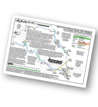
Route Summary:
Bourton-on-the-Water - The Warden's Way - River Eye - Lower Slaughter - Upper Slaughter - Brockhill Farm - Naunton - The Windrush Way - River Windrush - Aston Farm - Bourton-on-the-Water
|
Vital Statistics:
| Length: | 6.5 miles (10.5 km) |
| Ascent: | 272ft (83m) |
| Time: | 2.75hrs |
| Grade: | |

Route Summary:
Shipton Under Wychwood - Milton Under Wychwood - Grange Farm - Home Farm - Foxholes Nature Reserve - The Oxfordshire Way - Bruern Abbey - Shipton Under Wychwood
Not familiar with the area around CV6?
See these 30 nearest walks to UK Postcode CV6 on a google map


