Fifteen easy to follow walks from Wasdale National Trust Campsite, Wasdale Head, The Lake District, Cumbria, England
To reach Wasdale National Trust Campsite, Wasdale Head, in-car SatNav users should select the Latitude/Longitude (Lat Lon) screen and enter:
Lat = N54.45695 and Lon = W3.26248 or postcode: CA20 1EX
Not familiar with this campsite?
Fifteen easy to follow walks from Wasdale National Trust Campsite, Wasdale Head, The Lake District, Cumbria, England
Scroll down the list of walks below & click on each walk title (in blue) to locate it on the map above.
   |
Vital Statistics:
| Length: | 5.25 miles (8.5 km) |
| Ascent: | 2,123ft (647m) |
| Time: | 4 hrs |
| Grade: |  |

Route Summary:
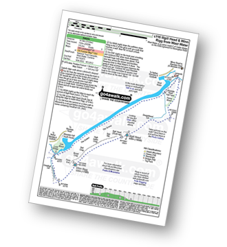
Wasdale Head - Mosedale Beck - Dore Head - Yewbarrow (North Top) - Yewbarrow - Bell Rib - Dropping Crag - Over Beck - Overbeck Bridge - Wasdale Head - Wast Water.
|
Vital Statistics:
| Length: | 6.25 miles (10 km) |
| Ascent: | 3,187ft (971m) |
| Time: | 5½ hrs |
| Grade: |  |

Route Summary:
Wasdale Head - Lingmell Gill - Brown Tongue - Hollow Stones - Mickledore - Scafell Pike - Mickledore - Lingmell Beck - Wasdale Head - Wast Water.
|
Vital Statistics:
| Length: | 9 miles (14.5 km) |
| Ascent: | 2,402ft (732m) |
| Time: | 5.75hrs |
| Grade: | |
Route Summary:
Wasdale Head - (National Trust Campsite) - Wast Water - Lingmell Gill - Illgill Head - Whin Rigg - Greathall Gill - Wasdale Hall Youth Hostel - Wast Water - Wasdale Head
|
Vital Statistics:
| Length: | 7.5 miles (12 km) |
| Ascent: | 3,218ft (981m) |
| Time: | 6 hrs |
| Grade: | |

Route Summary:
Wasdale Head - Lingmell Gill - Brown Tongue - Hollow Stones - Mickledore - Scafell Pike - The Corridor Route - Sty Head - Lingmell Beck - Gable Beck Bridge - Wasdale Head - Wast Water.
|
Vital Statistics:
| Length: | 9 miles (14.5 km) |
| Ascent: | 3,696ft (1,126m) |
| Time: | 7 hrs |
| Grade: |  |

Route Summary:
Wasdale Head - Wast Water - Lingmell - Lingmell Col - Scafell Pike - Broad Crag - Ill Crag - Great End - Esk Hause - Sty Head - Lingmell Beck - Gable Beck Bridge - Wasdale Head - Wast Water.
|
Vital Statistics:
| Length: | 7.5 miles (12 km) |
| Ascent: | 4,195ft (1,279m) |
| Time: | 7 hrs |
| Grade: | |

Route Summary:
Wasdale Head - (National Trust Campsite) - Wast Water - Lingmell - Corridor Route - Scafell Pike - Mickledore - Foxes Tarn - Symonds Knott - Sca Fell - Lingmell Gill - Wasdale Head - Wast Water.
|
Vital Statistics:
| Length: | 7.75 miles (12.5 km) |
| Ascent: | 4,808ft (1,465m) |
| Time: | 7.75hrs |
| Grade: | |

Route Summary:
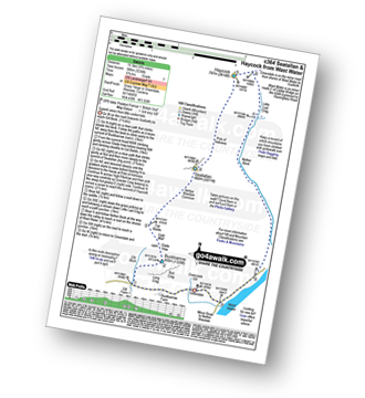
Wasdale Head - Kirk Fell - Kirk Fell (East Top) - Black Sail Pass - Looking Stead (Pillar) - High Level Route - Robinson's Cairn - Pillar - Wind Gap - Black Crag (Pillar) - Scoat Fell (Little Scoat Fell) - Steeple - Red Pike (Wasdale) - Dore Head - Mosedale Beck - Wasdale Head - Wast Water.
|
Vital Statistics:
| Length: | 9.75 miles (15.5 km) |
| Ascent: | 3,236ft (986m) |
| Time: | 6.75hrs |
| Grade: | |
Route Summary:
Greendale Farm - Gill Farm - Buckbarrow - Seatallan - Pots of Ashness - Gowder Crag - Haycock - Little Lad Crag - Nether Beck - Wast Water - Wasdale - Greendale Farm
|
Vital Statistics:
| Length: | 11 miles (17.5 km) |
| Ascent: | 4,782ft (1,457m) |
| Time: | 8.75hrs |
| Grade: |  |

Route Summary:
Wasdale Head - Mosedale Beck - Black Sail Pass - Looking Stead (Pillar) - High Level Route - Robinson's Cairn - Pillar - Wind Gap - Black Crag (Pillar) - Scoat Fell (Little Scoat Fell) - Steeple - Red Pike (Wasdale) - Dore Head - Yewbarrow (North Top) - Yewbarrow - Dropping Crag - Bell Rib - Over Beck - Wasdale Head - Wast Water.
|
Vital Statistics:
| Length: | 11.25 miles (18 km) |
| Ascent: | 5,100ft (1,554m) |
| Time: | 9.25hrs |
| Grade: | |

Route Summary:
Greendale Farm - Middle Fell (Wasdale) - Seatallan - Pots of Ashness - Gowder Crag - Haycock - Great Scoat Fell - Steeple - Scoat Fell (Little Scoat Fell) - Red Pike (Wasdale) - Dore Head - Yewbarrow (North Top) - Yewbarrow - Bell Rib - Dropping Crag - Overbeck Bridge - Wast Water - Greendale Farm
|
Vital Statistics:
| Length: | 9.75 miles (15.5 km) |
| Ascent: | 5,140ft (1,567m) |
| Time: | 8.75hrs |
| Grade: | |

Route Summary:
Wasdale Head - (National Trust Campsite) - Wast Water - Lingmell - Middleboot Knotts - Round How (Scafell) - Great End - Ill Crag - Broad Crag - Scafell Pike - Mickledore - Foxes Tarn - Symonds Knott - Sca Fell - Wast Water.
|
Vital Statistics:
| Length: | 11 miles (17 km) |
| Ascent: | 4,001ft (1,219m) |
| Time: | 8 hrs |
| Grade: | |

Route Summary:
Wasdale Head - Mosedale Beck - Black Sail Pass - High Level Route - Robinson's Cairn - Pillar - Wind Gap - Black Crag (Pillar) - Scoat Fell (Little Scoat Fell) - Red Pike (Wasdale) - Dore Head - Over Beck - Wasdale Head - Wast Water.
|
Vital Statistics:
| Length: | 11 miles (17.5 km) |
| Ascent: | 5,409ft (1,648m) |
| Time: | 9½ hrs |
| Grade: | |

Route Summary:
Wasdale Head - (National Trust Campsite) - Wast Water - Lingmell - Corridor Route - Great End - Ill Crag - Broad Crag - Scafell Pike - Mickledore - Foxes Tarn - Symonds Knott - Sca Fell - Slight Side - Broad Tongue - Hardrigg Gill - Wasdale Head - Wast Water.
|
Vital Statistics:
| Length: | 11.25 miles (18 km) |
| Ascent: | 5,819ft (1,773m) |
| Time: | 10 hrs |
| Grade: |  |

Route Summary:
Wasdale Head - Moses' Trod - Lingmell Beck - Gable Beck Bridge - Sty Head - Great Gable - Westmorland Cairn - Beck Head - Beckhead Tarn - Kirk Fell (East Top) - Kirk Fell - Black Sail Pass - Looking Stead (Pillar) - High Level Route - Robinson's Cairn - Pillar - Wind Gap - Black Crag (Pillar) - Scoat Fell (Little Scoat Fell) - Steeple - Red Pike (Wasdale) - Dore Head - Mosedale Beck - Wasdale Head - Wast Water.
|
Vital Statistics:
| Length: | 15.25 miles (24.5 km) |
| Ascent: | 4,841ft (1,475m) |
| Time: | 10½ hrs |
| Grade: | |

Route Summary:
Wasdale Head - (National Trust Campsite) - Wast Water - Lingmell Gill - Illgill Head - Whin Rigg - Greathall Gill - Low Wood - Lund Bridge - Woodhow Farm - Woodhow Tarn - Scale Farm - Tosh Tarn - Gill Farm - Gill Beck - Buckbarrow - Cold Well - Nether Wasdale Common - Seatallan - Windscale Hows - Middle Fell (Wasdale) - Greendale Farm - Nether Beck - Overbeck Bridge - Wasdale Head - Wast Water.


