The Mountains, Peaks, Tops and Hills in Yorkshire of with all the tops you have already bagged in first & then the ones you are yet to climb second.
Yorkshire of region of England comprises the traditional counties of East Riding of Yorkshire, North Yorkshire, South Yorkshire and West Yorkshire.
If you count only the Marilyns there are 20 tops to climb, bag & conquer and the highest point is Whernside at 736m (2,416ft).
To see these Mountains, Peaks, Tops and Hills displayed in different ways - see the options in the left-hand column and towards the bottom of this page.
![]() Your Personal Bagging Record for Yorkshire of
Your Personal Bagging Record for Yorkshire of
LOG ON and RELOAD this page to show which Mountains, Peaks, Tops and Hills you have already climbed, bagged & conquered [. . . more details]
Scroll down this list of mountains, peaks, tops & hills below and tap/click on each name (in blue) to locate it on the map above.
See this list in: Alphabetical Order | Height Order‡
To reverse the order select the link again.
Mountain, Peak, Top or Hill already bagged:
Bagged
Top yet to be climbed, bagged & conquered:
Bagged

![]()
1. Whernside
736m (2416ft)
Marilyn
See more details, photos, trip reports and easy-to-follow walks up Whernside
![]()
2. Ingleborough
724m (2375ft)
Marilyn
See more details, photos, trip reports and easy-to-follow walks up Ingleborough
![]()
3. Great Shunner Fell
716m (2349ft)
Marilyn
See more details, photos, trip reports and easy-to-follow walks up Great Shunner Fell
![]()
4. Great Whernside
704m (2310ft)
Marilyn
See more details, photos, trip reports and easy-to-follow walks up Great Whernside
![]()
5. Buckden Pike
702m (2303ft)
Marilyn
See more details, photos, trip reports and easy-to-follow walks up Buckden Pike
![]()
6. Pen-y-ghent
694m (2277ft)
Marilyn
See more details, photos, trip reports and easy-to-follow walks up Pen-y-ghent
![]()
7. Rogan's Seat
672m (2205ft)
Marilyn
See more details, photos, trip reports and easy-to-follow walks up Rogan's Seat
![]()
8. Dodd Fell Hill
668m (2192ft)
Marilyn
See more details, photos, trip reports and easy-to-follow walks up Dodd Fell Hill
![]()
9. Fountains Fell
668m (2192ft)
Marilyn
See more details, photos, trip reports and easy-to-follow walks up Fountains Fell
![]()
10. Birks Fell
610m (2002ft)
Marilyn
See more details, photos, trip reports and easy-to-follow walks up Birks Fell
![]()
11. Black Hill (Soldier's Lump)
582m (1910ft)
Marilyn
See more details, photos, trip reports and easy-to-follow walks up Black Hill (Soldier's Lump)
![]()
12. Hoove Faggergill
554m (1818ft)
Marilyn
See more details, photos, trip reports and easy-to-follow walks up Hoove Faggergill
![]()
13. Cracoe Fell
507m (1663ft)
Marilyn
See more details, photos, trip reports and easy-to-follow walks up Cracoe Fell
![]()
14. Kisdon
499m (1638ft)
Marilyn
See more details, photos, trip reports and easy-to-follow walks up Kisdon
![]()
15. Urra Moor (Round Hill)
454m (1490ft)
Marilyn
See more details, photos, trip reports and easy-to-follow walks up Urra Moor (Round Hill)
![]()
16. Cringle Moor (Drake Howe)
434m (1424ft)
Marilyn
See more details, photos, trip reports and easy-to-follow walks up Cringle Moor (Drake Howe)
![]()
17. Rombalds Moor (Ilkley Moor)
402m (1319ft)
Marilyn
See more details, photos, trip reports and easy-to-follow walks up Rombalds Moor (Ilkley Moor)
![]()
18. Sharp Haw
357m (1171ft)
Marilyn
See more details, photos, trip reports and easy-to-follow walks up Sharp Haw
![]()
19. Gisborough Moor
328m (1076ft)
Marilyn
See more details, photos, trip reports and easy-to-follow walks up Gisborough Moor
![]()
20. Bishop Wilton Wold (South Wold)
246m (807ft)
Marilyn
See more details, photos, trip reports and easy-to-follow walks up Bishop Wilton Wold (South Wold)
![]() Your Personal Bagging Record for Yorkshire of
Your Personal Bagging Record for Yorkshire of
LOG ON and RELOAD this page to show which Mountains, Peaks, Tops and Hills you have already climbed, bagged & conquered [. . . more details]
View these 20 Mountains, Peaks, Tops and Hills:
- On an Interactive Google Map with a list of tops below it.
(makes it easier to locate a particular top) - On a Detailed List in:
Alphabetical Order | Height Order - On one page with 'yet-to-be-bagged' listed 1st
& then 'already-bagged' tops listed 2nd in:
Alphabetical Order | Height Order - On one page with 'already-bagged' tops listed 1st
& then 'yet-to-be-bagged' tops listed 2nd in:
Alphabetical Order | Height Order
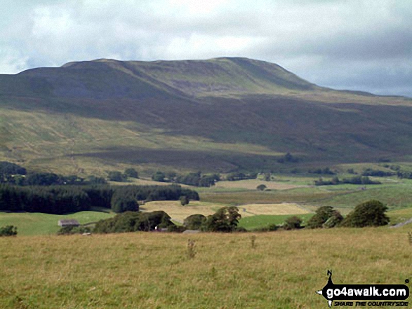 Whernside in Yorkshire of
Photo: David Hayter
Is there a Mountain, Peak, Top or Hill missing from the above google map or list?


