   |
Vital Statistics:
| Length: | 10mls (16km) |
| Ascent: | 3,349ft (1,082m) |
| Time: | 7¼hrs |
| Grade: |  |

Route outline for walk c405:
Hawes End - Derwent Water - Skelgill Bank - Woodford's Path - Cat Bells (Catbells) - Maiden Moor - Narrow Moor - High Spy (North Top) - High Spy - Dale Head Tarn - Rigghead Quarries - The Allerdale Ramble - Castle Crag - River Derwent - Yewdale Knott - Manesty - Manesty Band - Hawes End - Derwent Water.
Peaks, Summits and Tops reached on this walk:
 1 English Mountain |
 4 Wainwrights |
 2 English Nuttalls |
 0 English Deweys |
 0 Wainwright Outlying Fells |
 0 Marilyns |
 0 Bridgets |
Peak Bagging Statistics for this walk:
The highest point of this walk is High Spy at 653m (2143ft). High Spy is classified as an English Mountain (Hewitt) (141st highest in England, 243rd highest in England & Wales) and a Wainwright (No. 113).
High Spy is also known as an English Nuttall (189th highest in England, 326th highest in England & Wales).
Completing this walk will also take you to the top of High Spy (North Top) at 634m (2081ft). High Spy (North Top) is also known as an English Nuttall (209th highest in England, 359th highest in England & Wales).
You will also reach the summit of Maiden Moor at 575m (1887ft). Maiden Moor is classified as an Wainwright (No. 138).
Along the way you will also bag:
- Cat Bells (Catbells) at 451m (1480ft). Cat Bells (Catbells) is classified as a Wainwright (No. 189)
- Castle Crag at 290m (952ft). Castle Crag is classified as a Wainwright (No. 214)
National Trails & Long Paths included on this walk:
Part of this walk follows a section of The Allerdale Ramble, an 87km (54 miles) linear footpath connecting Seathwaite in Cumbria, with Grune Point in Cumbria, England. The Allerdale Ramble is waymarked by named posts. For more walks that include a section of this trail see The Allerdale Ramble.
You can find this walk and other nearby walks on these unique free-to-access Interactive Walk Planning Maps:
1:25,000 scale OS Explorer Map (orange/yellow covers):
1:50,000 scale OS Landranger Maps (pink/magenta covers):
Some Photos and Pictures from Walk c405 Cat Bells, High Spy and Castle Crag from Hawes End
In no particular order . . .
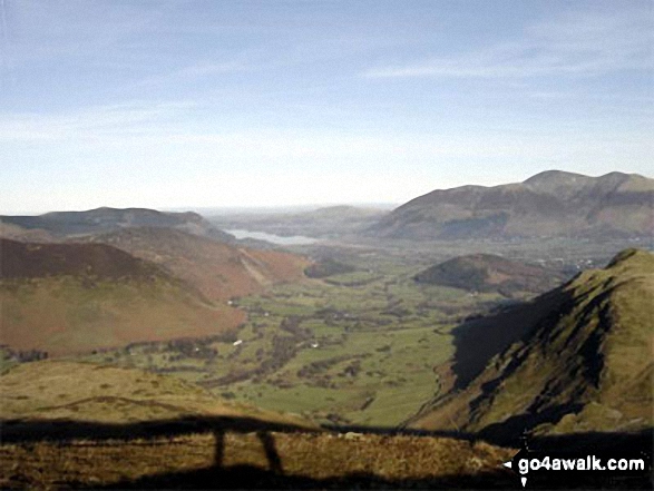
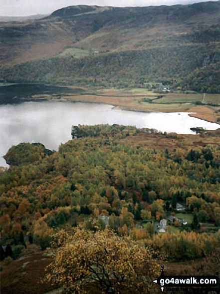
The Newlands Valley from High Spy with Bassenthwaite Lake in the distance and The Skiddaw Massif to the right
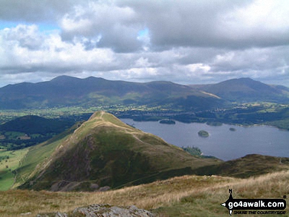


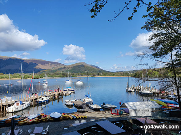
Cat Bells (Catbells) (foreground) with Derwent Water, Keswick and Skiddaw (centre left) and Blencathra (right) from Maiden Moor

High Spy (North Top), High Spy, Maiden Moor, Hindscarth (left), Robinson, Crag Hill (Eel Crag), Causey Pike, Barrow (Newlands) (centre), Newlands, Bassenthwaite Lake, Swinside, Skiddaw, Derwent Water and Blencathra (right) beyond from Cat Bells (Catbells)
. . . load all 98 walk photos from Walk c405 Cat Bells, High Spy and Castle Crag from Hawes End
Send us your photographs and pictures from your walks and hikes
We would love to see your photographs and pictures from walk c405 Cat Bells, High Spy and Castle Crag from Hawes End. Send them in to us as email attachments (configured for any computer) along with your name and where the picture was taken to:
and we shall do our best to publish them.
(Guide Resolution = 300dpi. At least = 660 pixels (wide) x 440 pixels (high).)

You can also submit photos from walk c405 Cat Bells, High Spy and Castle Crag from Hawes End via our Facebook Page.
NB. Please indicate where each photo was taken.
To contribute to go4awalk.com or to contact us about anything at all - see Talk To Us.
For help see Help.
go4awalk.com and go4awalk.co.uk are registered trademarks of TMDH Limited.
Copyright © 2000-2026 TMDH Limited. All rights reserved.
Copyright Terms & Conditions Privacy Statement
A - Z Walks Home Log On/Accounts Photo Gallery Walk Ideas and Collections Fell Facts Hill Skills Walking Questions and Answers Your Stories News Competitions Product Reviews/Gear Tests Walking Gear Guides Peaks and Mountains Peak Bagging Find New Walking Friends Camping GPS Waypoints for Walking Contents Walk Search Talk To Us go4awalk.com Help Free Example Walks Newsletter


