Nine easy to follow pub walks from Ye Olde Cheshire Cheese, Longnor, The Peak District, Staffordshire, England
To reach Ye Olde Cheshire Cheese, Longnor, in-car SatNav users should select the Latitude/Longitude (Lat Lon) screen and enter:
Lat = N53.18130 and Lon = W 1.8675
Not familiar with this pub?
Nine easy to follow pub walks from Ye Olde Cheshire Cheese, Longnor, The Peak District, Staffordshire, England
Scroll down the list of walks below & click on each walk title (in blue) to locate it on the map above.
   |
Vital Statistics:
| Length: | 4.5 miles (7 km) |
| Ascent: | 538ft (164m) |
| Time: | 2.25hrs |
| Grade: |  |

Route Summary:
Longnor - The Manifold Trail - Moss Carr Farm - Hollinsclough - Swallow Brook - Yewtree Grange - Under The Hill - Longnor
|
Vital Statistics:
| Length: | 5 miles (8 km) |
| Ascent: | 640ft (195m) |
| Time: | 2½ hrs |
| Grade: |  |

Route Summary:
Longnor - The Manifold Trail - River Manifold - Lower Boothfold Farm - Ludburn Farm - Bridge End - The Ferns Farm - Heath House - Longnor
|
Vital Statistics:
| Length: | 4.75 miles (7.5 km) |
| Ascent: | 659ft (201m) |
| Time: | 2½ hrs |
| Grade: | |

Route Summary:
Longnor - Beggar's Bridge - River Dove - Crowdecote (Crowdicote) - Bridge End Farm - Under Wwhitle Farm - Over Boothlow Farm - The Manifold Trail - River Manifold - Longnor.
|
Vital Statistics:
| Length: | 4.5 miles (7 km) |
| Ascent: | 834ft (254m) |
| Time: | 2½ hrs |
| Grade: | |
Route Summary:
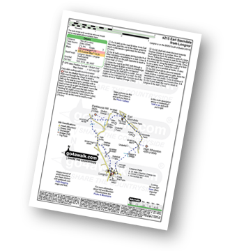
Longnor - River Dove - Beggar's Bridge - High Wheeldon - Abbotside Farm - Earl Sterndale - Hitter Hill - Parkhouse Hill - High Acres - Yewtree Grange - Underhill Farm - Longnor
|
Vital Statistics:
| Length: | 7 miles (11 km) |
| Ascent: | 1,090ft (332m) |
| Time: | 3.75hrs |
| Grade: |  |
Route Summary:
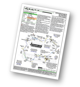
Longnor - The Manifold Trail - Gauledge Farm - Fawside Farm - The River Manifold - Hardings Booth - Hollinsclough Moor - Hollinsclough - Swallow Brook - Earl Sterndale - Abbotside Farm - Green Lane - Beaggar's Bridge - Longnor
|
Vital Statistics:
| Length: | 7.5 miles (12 km) |
| Ascent: | 811ft (247m) |
| Time: | 3½ hrs |
| Grade: | |
Route Summary:
Longnor - The Manifold Trail - River Manifold - Lower Boothfold Farm - Ludburn Farm - Reaps Moor - Blake Brook - Boosley Grange - Bank House Farm - Shining Ford Farm - Hardings Booth Farm - Fawside Farm - Gualedge Farm - Longnor
|
Vital Statistics:
| Length: | 14.5 miles (23.5 km) |
| Ascent: | 3,049ft (929m) |
| Time: | 8½ hrs |
| Grade: |  |
Route Summary:
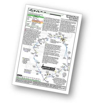
Longnor - The Manifold Trail - Gauledge Farm - Fawside Farm - The River Manifold - Hardings Booth - Ball Bank Farm - The River Manifold - Heathylee House - Hollinsclough Moor - Wilshaw Bottom - Wilshaw Farm - Moorside Farm - Hollinsclough - Hollins Farm - Swallow Brook - Parkhouse Hill - Hitter Hill - Earl Sterndale - Abbots Grove - Wheeldon Trees - High Wheeldon - Crowdecote - Bridge End Farm - Pilsbury Castle Hills - Pilsbury - Sheen Lane Farm - Ridge End Farm - The Manifold Trail - Lower Boothlow Farm - Folds End Farm - Longnor
|
Vital Statistics:
| Length: | 11 miles (17.5 km) |
| Ascent: | 1,342ft (409m) |
| Time: | 5.25hrs |
| Grade: | |

Route Summary:
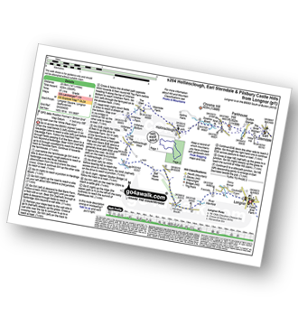
Longnor - River Manifold - The Manifold Trail - Over Boothlow Farm - Lower Boothlow Farm - Hill End Farm - Sheen Hill - Slate House Farm - Sheen - Brund - River Manifold - Brund Mill - New Road Farm - Field House Farm - Reaps Moor - Black Brook - Smedley Sytch - Boosley Grange - Fawfield Head - Bank House - Shining Ford - The Manifold Trail - Hardings Booth - Fawside Farm - Gauledge Farm,Longnor.
|
Vital Statistics:
| Length: | 11.5 miles (18.5 km) |
| Ascent: | 1,487ft (453m) |
| Time: | 2.75hrs |
| Grade: |  |

Route Summary:
Longnor - The Manifold Trail - Gauledge Farm - Fawside Farm - The River Manifold - Hardings Booth - Shining Ford - Holly Grove Farm - Newtown - Lady Edge - Round Knowl - Noon Sun Farm - Blake Mere (Merryton Low) - Blake Brook - Lower Fleetgreen Farm - Little Fernyford Farm - The Manifold Trail - Brund Mill - Pool Farm - Lower Boothlow Farm - Over Boothlow Farm - Folds End Farm - Longnor


