Thirteen easy to follow pub walks from Tweedies Bar & Lodge, Grasmere, The Lake District, Cumbria, England
To reach Tweedies Bar & Lodge, Grasmere, in-car SatNav users should select the Latitude/Longitude (Lat Lon) screen and enter:
Lat = N54.45808 and Lon = W 3.02581
Tap/mouse over a coloured circle (1-3 easy walks, 4-6 moderate walks, 7-9 hard walks) and click to select.
Tap/mouse over a coloured circle (1-3 easy walks, 4-6 moderate walks, 7-9 hard walks) and click to select.
Thirteen easy to follow pub walks from Tweedies Bar & Lodge, Grasmere, The Lake District, Cumbria, England
Scroll down the list of walks below & click on each walk title (in blue) to locate it on the map above.
   |
Vital Statistics:
| Length: | 8.75 miles (14 km) |
| Ascent: | 558ft (170m) |
| Time: | 3½ hrs |
| Grade: |  |
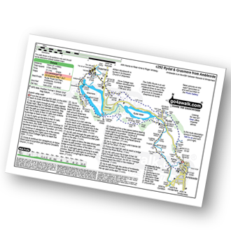
Route Summary:
Ambleside - Scandale Beck - Rydal Park - Rydal Hall - Rydal - Rydal Mount - Rydal Water - Coffin Route - Dove Cottage - Grasmere Village - Silverhowe - The Lea - Grasmere - Red Bank - Rydal Cave - Jobson Close - Rough Intake - Pelter Bridge - Foxghyll - River Rothay - Rothay Park - Ambleside
|
Vital Statistics:
| Length: | 3.75 miles (6 km) |
| Ascent: | 1,201ft (366m) |
| Time: | 3 hrs |
| Grade: | |

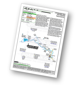
Route Summary:
Grasmere - Goody Bridge - Wainwright's Coast to Coast Walk - Easedale House - High Raven Crag - Helm Crag - The Lion and The Lamb - The Howitzer - Goody Bridge - Grasmere
|
Vital Statistics:
| Length: | 4.5 miles (7.5 km) |
| Ascent: | 1,296ft (395m) |
| Time: | 3 hrs |
| Grade: |  |

|
Vital Statistics:
| Length: | 6.25 miles (10 km) |
| Ascent: | 1,172ft (357m) |
| Time: | 3½ hrs |
| Grade: | |
Route Summary:
Grasmere - Goody Bridge - Easedale Beck - Sourmilk Gill - Brinhowe Crag - Easedale - Sourmilk Falls - Easedale Tarn - Far Easedale Gill - Stythwaite Steps - Grasmere
|
Vital Statistics:
| Length: | 8.75 miles (14 km) |
| Ascent: | 2,212ft (674m) |
| Time: | 5½ hrs |
| Grade: |  |

Route Summary:
Grasmere - Goody Bridge - High Raven Crag - Helm Crag - The Lion and The Lamb - The Howitzer - Gibson Knott - Calf Crag - Wainwright's Coast to Coast Walk - Brownrigg Moss - Moor Moss - Far Easdale Gill - Goody Bridge - Grasmere
|
Vital Statistics:
| Length: | 8.5 miles (13.5 km) |
| Ascent: | 2,402ft (732m) |
| Time: | 5½ hrs |
| Grade: | |
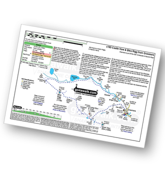
Route Summary:
Grasmere - Castle How - Blea Rigg - Easedale Tarn - Sour Milk Gill - Easedale - Goody Bridge - Grasmere
|
Vital Statistics:
| Length: | 7 miles (11 km) |
| Ascent: | 2,661ft (811m) |
| Time: | 5.25hrs |
| Grade: | |

Route Summary:
Grasmere - River Rothay - Grasmere (A591) - Stone Arthur - Great Rigg - Rydal Fell (Heron Pike North Top) - Heron Pike - Butter Crag - Alcock Tarn - Brackenfell - Dove Cottage - Grasmere (A591) - Grasmere
|
Vital Statistics:
| Length: | 7.5 miles (12 km) |
| Ascent: | 3,116ft (950m) |
| Time: | 6 hrs |
| Grade: | |

Route Summary:
Grasmere - Wainwright's Coast to Coast Walk - Mill Bridge - Little Tongue - Seat Sandal - Grisedale Tarn - Fairfield - Rydal Head - Great Rigg - Stone Arthur - Grasmere
|
Vital Statistics:
| Length: | 8.5 miles (13.5 km) |
| Ascent: | 2,435ft (742m) |
| Time: | 5½ hrs |
| Grade: | |

Route Summary:
Grasmere - Goody Bridge - Ghyll Foot Farm - Green Burn - Greenburn Bottom - Contra Breast - Dead Pike - Steel Fell (Dead Pike) - Brownrigg Moss - Calf Crag - Gibson Knott - Helm Crag - The Lion and The Lamb - The Howitzer - High Raven Crag - Grasmere
|
Vital Statistics:
| Length: | 10 miles (16 km) |
| Ascent: | 2,936ft (895m) |
| Time: | 6½ hrs |
| Grade: |  |
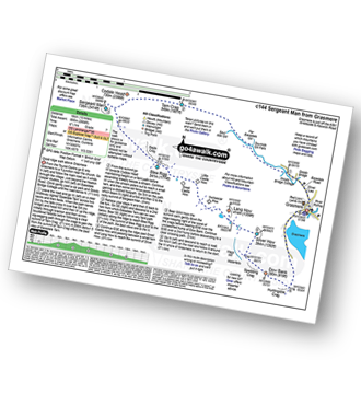
Route Summary:
Grasmere - Sour Milk Gill - Sourmilk Gill Falls - Tarn Crag (Easedale) - Sergeant Man - Blea Rigg - Great Castle How - Little Castle How - Raw Pike - Swinescar Pike - Lang How - Silver How - Spedding Crag - Dow Bank - Huntingstile Crag - Grasmere
|
Vital Statistics:
| Length: | 10.25 miles (16.5 km) |
| Ascent: | 3,128ft (953m) |
| Time: | 6.75hrs |
| Grade: | |

Route Summary:
Grasmere - Goody Bridge - High Raven Crag - Helm Crag - The Lion and The Lamb - The Howitzer - Gibson Knott - Calf Crag - Brownrigg Moss - Greenup Edge - High Raise (Langdale) - Sergeant Man - Belles Knott - Coledale Tarn - Easedale Tarn - Sour Milk Gill - Easedale - Grasmere
|
Vital Statistics:
| Length: | 9.5 miles (15 km) |
| Ascent: | 3,682ft (1,122m) |
| Time: | 7.25hrs |
| Grade: | |

Route Summary:
Grasmere - Mill Bridge - Little Tongue - Seat Sandal - Grisedale Tarn - Fairfield - Rydal Head - Great Rigg - Rydal Fell (Heron Pike North Top) - Heron Pike - Alcock Tarn - Grasmere
|
Vital Statistics:
| Length: | 13.75 miles (22 km) |
| Ascent: | 3,991ft (1,216m) |
| Time: | 9 hrs |
| Grade: |  |

Route Summary:
Grasmere - Allan Bank - Wray Gill - Silver How - Lang How - Sinescar Pike - Little Castle How - Great Castle How - Blea Rigg - Sergeant Man - Thunacar Knott - Pavey Ark - Harrison Stickle - Loft Crag - Pike of Stickle (Pike O' Stickle) - High Raise (Langdale) - Codale Head - Tarn Crag (Easedale) - Far Easedale Gill - Sourmilk Falls - Far Easedale Beck - Goody Bridge - Grasmere


