One easy to follow pub walk from The Watts Russell Arms, Hopedale, The Peak District, Staffordshire, England
To reach The Watts Russell Arms, Hopedale, in-car SatNav users should select the Latitude/Longitude (Lat Lon) screen and enter:
Lat = N53.09160 and Lon = W 1.81795
Tap/mouse over a coloured circle (1-3 easy walks, 4-6 moderate walks, 7-9 hard walks) and click to select.
Tap/mouse over a coloured circle (1-3 easy walks, 4-6 moderate walks, 7-9 hard walks) and click to select.
One easy to follow pub walk from The Watts Russell Arms, Hopedale, The Peak District, Staffordshire, England
Scroll down the list of walks below & click on each walk title (in blue) to locate it on the map above.
   |
Vital Statistics:
| Length: | 9.25 miles (15 km) |
| Ascent: | 1,769ft (539m) |
| Time: | 5.25hrs |
| Grade: |  |
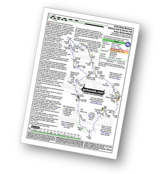
Route Summary:
Alstonefield - Dale Bottom - Hopedale - Castern Wood Nature Reserve - Wetton Low - Wetton - Wetton Hill (West Top) - Wetton Hill - Ecton Hill - Acton Moor - Gateham Grange - Gateham Farm - Steep Low - Alstonefield


