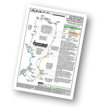
Four easy to follow pub walks from The Waterloo Inn, Biggin, The Peak District, Derbyshire, England
To reach The Waterloo Inn, Biggin, in-car SatNav users should select the Latitude/Longitude (Lat Lon) screen and enter:
Lat = N53.13237 and Lon = W 1.77361
Tap/mouse over a coloured circle (1-3 easy walks, 4-6 moderate walks, 7-9 hard walks) and click to select.
Tap/mouse over a coloured circle (1-3 easy walks, 4-6 moderate walks, 7-9 hard walks) and click to select.
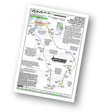
Four easy to follow pub walks from The Waterloo Inn, Biggin, The Peak District, Derbyshire, England
Scroll down the list of walks below & click on each walk title (in blue) to locate it on the map above.
   |
Vital Statistics:
| Length: | 6.25 miles (10 km) |
| Ascent: | 1,224ft (373m) |
| Time: | 3½ hrs |
| Grade: |  |

Route Summary:
Hartington - Crossland Sides - Pennilow - Beresford Dale - Pike Pool - Wolfscote Dale - River Dove - Peasland Rocks - Biggin Dale - Furny Bottom - Dale End - Biggin - Hartington
|
Vital Statistics:
| Length: | 9.5 miles (15.5 km) |
| Ascent: | 705ft (215m) |
| Time: | 1.25hrs |
| Grade: |  |
Route Summary:
Alsop en le Dale Station - New Hanson Grange - Milldale - River Dove - Mill Dale - Lode Mill Bridge - Coldeaton Bridge - Iron Tors - Gipsy Bank - Drabber Tor - Peasland Rocks - Wolfscote Dale - Biggin Dale - Furny Bottom - Dale End (Heathcote) - Biggin - The Tissington Trail - Alsop en le Dale Station
|
Vital Statistics:
| Length: | 8.75 miles (14 km) |
| Ascent: | 1,473ft (449m) |
| Time: | 4.75hrs |
| Grade: |  |

Route Summary:
Hartington - Crossland Sides - Pennilow - Beresford Dale - Pike Pool - How Narrowdale - The Rakes - Alstonefield - Overdale - Gipsy Bank - River Dove - Coldeaton Bridge - Iron Tors - Drabber Tor - Wolfscote Dale - Peasland Rocks - Biggin Dale - Furny Bottom - Dale End - Biggin - Hartington
|
Vital Statistics:
| Length: | 15.5 miles (24.5 km) |
| Ascent: | 1,742ft (531m) |
| Time: | 7.25hrs |
| Grade: |  |
Route Summary:
Tissington - The Tissington Trail - Thorpe Station - Thorpe - Pike House - Thorpe Pasture - Bostern Grange Farm - Milldale - River Dove - Mill Dale - Lode Mill Bridge - Coldeaton Bridge - Wolfscote Dale - Biggin Dale - Biggin - The Tissington Trail - Alsop en le Dale Station - Tissington


