Five easy to follow pub walks from The Long Mynd Hotel, Church Stretton, Shropshire, England
To reach The Long Mynd Hotel, Church Stretton, in-car SatNav users should select the Latitude/Longitude (Lat Lon) screen and enter:
Lat = N52.53557 and Lon = W 2.81372
Tap/mouse over a coloured circle (1-3 easy walks, 4-6 moderate walks, 7-9 hard walks) and click to select.
Tap/mouse over a coloured circle (1-3 easy walks, 4-6 moderate walks, 7-9 hard walks) and click to select.
Five easy to follow pub walks from The Long Mynd Hotel, Church Stretton, Shropshire, England
Scroll down the list of walks below & click on each walk title (in blue) to locate it on the map above.
   |
Vital Statistics:
| Length: | 5.25 miles (8.5 km) |
| Ascent: | 945ft (288m) |
| Time: | 3 hrs |
| Grade: |  |
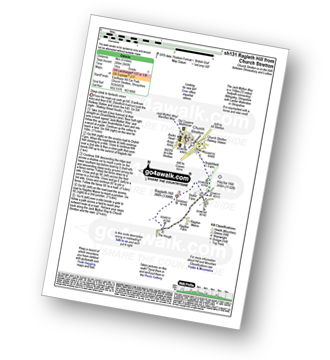
Route Summary:
Church Stretton - The Jack Mytton Way - Snatchfield Farm - Clemcroft - Ragleth Hill - Ragdon Manor - Church Stretton
|
Vital Statistics:
| Length: | 7 miles (11 km) |
| Ascent: | 1,214ft (370m) |
| Time: | 3.75hrs |
| Grade: |  |

Route Summary:
Church Stretton - Three Fingers Rock - Caer Caradoc Hill - Little Caradoc - Comley - Church Stretton
|
Vital Statistics:
| Length: | 5.75 miles (9 km) |
| Ascent: | 1,027ft (313m) |
| Time: | 3.25hrs |
| Grade: | |
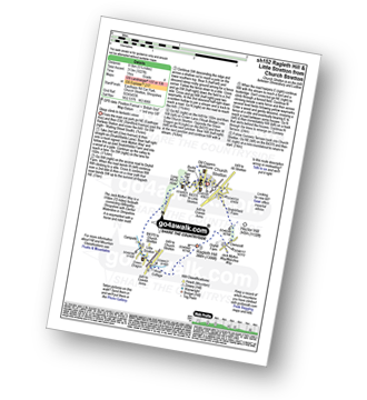
Route Summary:
Church Stretton - The Jack Mytton Way - Snatchfield Farm - Clemcroft - Ragleth Hill - Little Stretton - Church Stretton
|
Vital Statistics:
| Length: | 8.75 miles (14 km) |
| Ascent: | 1,387ft (423m) |
| Time: | 4.75hrs |
| Grade: |  |
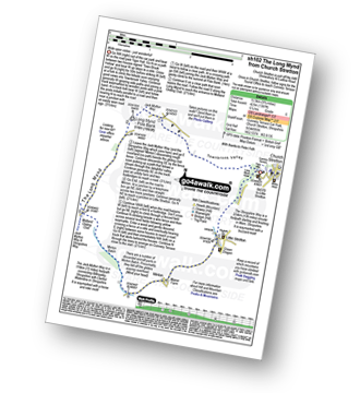
Route Summary:
Church Stretton - Town Brook - The Jack Mytton Way - The Long Mynd - Pole Bank (Long Mynd) - Midland Gliding Club - Minton Bach - Minton - Little Stretton - Chruch Stretton.
|
Vital Statistics:
| Length: | 10.25 miles (16.5 km) |
| Ascent: | 2,435ft (742m) |
| Time: | 6.25hrs |
| Grade: |  |

Route Summary:
Church Stretton - The Jack Mytton Way - Snatchfield Farm - Clemcroft - Ragleth Hill - Ragdon Manor - Gaerstones Farm - Caer Caradoc Hill - Little Caradoc - Church Stretton


