Seven easy to follow pub walks from The Howtown Hotel, Howtown, The Lake District, Cumbria, England
To reach The Howtown Hotel, Howtown, in-car SatNav users should select the Latitude/Longitude (Lat Lon) screen and enter:
Lat = N54.56857 and Lon = W 2.86273
Tap/mouse over a coloured circle (1-3 easy walks, 4-6 moderate walks, 7-9 hard walks) and click to select.
Tap/mouse over a coloured circle (1-3 easy walks, 4-6 moderate walks, 7-9 hard walks) and click to select.
Seven easy to follow pub walks from The Howtown Hotel, Howtown, The Lake District, Cumbria, England
Scroll down the list of walks below & click on each walk title (in blue) to locate it on the map above.
   |
Vital Statistics:
| Length: | 5 miles (8 km) |
| Ascent: | 912ft (278m) |
| Time: | 2.75hrs |
| Grade: |  |
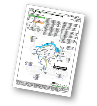
Route Summary:
Howtown - The Coombs - St Peter's Church - Lanty Tarn - Martindale - Christy Bridge - Howegrain Beck - Sandwick Beck - Sandwick - Hallinhag Wood - Geordie's Crag - Waternook - Howtown
|
Vital Statistics:
| Length: | 4.75 miles (7.5 km) |
| Ascent: | 1,292ft (394m) |
| Time: | 3 hrs |
| Grade: |  |
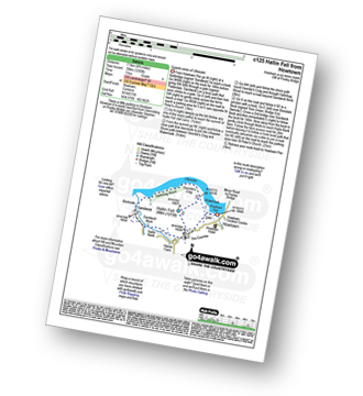
Route Summary:
Howtown - St Peter's Church - Hallin Fell - Geordie's Crag - Hallinhag Wood - Sandwick - Sandwick Beck - Howtown
|
Vital Statistics:
| Length: | 7.5 miles (12 km) |
| Ascent: | 2,283ft (696m) |
| Time: | 5.25hrs |
| Grade: |  |

Route Summary:
Howtown - Steel Knotts (Pikeawassa) - Brownthwaite Crag - Keasgill Head - Wether Hill (South Top) - Wether Hill - Loadpot Hill - Bonscale Pike - Bonscale Tower - Swarthbeck Gill - Howtown
|
Vital Statistics:
| Length: | 8.5 miles (13.5 km) |
| Ascent: | 1,994ft (608m) |
| Time: | 5 hrs |
| Grade: | |

Route Summary:
Howtown - Lock Bank - White Knott - Barton Fell - Whinny Crag - Arthur's Pike - Loadpot Hill - Bonscale Pike - Swarthbeck Gill - Howtown
|
Vital Statistics:
| Length: | 11.25 miles (18 km) |
| Ascent: | 2,736ft (834m) |
| Time: | 6.75hrs |
| Grade: |  |

Route Summary:
St Peter's Church (Martindale) - Howtown - Swarthbeck Gill - White Knott - Barton Fell - Whinny Crag - Arthur's Pike - Swarth Beck - Bonscale Tower - Bonscale Pike - Loadpot Hill - Wether Hill - Wether Hill (South Top) - Keasgill Head - Steel Knotts (Pikeawassa) - Steel End - St Peter's Church (Martindale) - Howtown
|
Vital Statistics:
| Length: | 9.75 miles (15.5 km) |
| Ascent: | 3,470ft (1,058m) |
| Time: | 7 hrs |
| Grade: | |
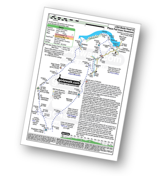
Route Summary:
St Peter's Church (Martindale) - Howtown - Howegrain Beck - Christy Bridge - Beda Head (Beda Fell) - Martindale Common - Angletarn Pikes - Angle Tarn (Martindale) - Boredale Hause - Steel Edge - Place Fell - High Dodd (Sleet Fell) - Sandwick - Hallinhag Wood - Geordies Crag - Hallin Fell (Martindale) - Howtown
|
Vital Statistics:
| Length: | 14.5 miles (23 km) |
| Ascent: | 4,555ft (1,388m) |
| Time: | 9.75hrs |
| Grade: |  |

Route Summary:
St Peter's Church (Martindale) - Howtown - Steel Knotts (Pikeawassa) - Keasgill Head - High Raise (Mardale) - Kidsty Pike - Rampsgill Head - The Knott - Rest Dodd - The Nab - Satura Crag - Brock Crags - Angle Tarn (Martindale) - Angletarn Pikes - Bedafel Knott - Beda Head (Beda Fell) - Winter Crag - Christy Bridge - Howegrain Beck - Martindale - St Peter's Church (Martindale) - Howtown


