12 easy-to-follow walk, route maps of all grades on OS Landranger Map 36 Grantown & Aviemore, Cairngorm Mountains
Twelve easy-to-follow walk, route maps of all grades on OS Landranger Map 36 Grantown & Aviemore, Cairngorm Mountains in Walk Grade OrderTap/mouse over a coloured circle (1-3 easy walks, 4-6 moderate walks, 7-9 hard walks) and click to select.
You can use these checkboxes to show only the grades of walk you are interested in:-
Twelve easy-to-follow walk, route maps of all grades on OS Landranger Map 36 Grantown & Aviemore, Cairngorm Mountains in Walk Grade Order
Scroll down the list of walks below & click on each walk title (in blue) to locate it on the map above.
See this list of walks, routes & maps in:
Grade Order | Length Order | Time Order | Walk Number or Start Location Order
NB. To reverse (toggle) this order, click Grade Order again
   |
Vital Statistics:
| Length: | 11.5 miles (18.5 km) |
| Ascent: | 4,260ft (1,298m) |
| Time: | 8½ hrs |
| Grade: |  |

Route Summary:
Corrour Bothy - Lairig Ghru - Allt a' Coire Odhar - Coire Odhar - The Devil's Point - Stob Coire an t-Saighdeir (Cairn Toul) - Cairn Toul (Carn an t-Sabhail) - Coire An an t-Sabhail - Sgor An Lochain Uaine (The Angel's Peak) - Garbh Core Mor - Carn na Criche (Braeriach) - Clais Luinneag - Loch Nan Stuirteng - Allt Clais an t-Sabhail - Allt a' Core Cath Nam Fionn - Glen Geusachan - Geusachan Burn - River Dee - Corrour Bothy - Lairig Ghru.
|
Vital Statistics:
| Length: | 12.75 miles (20.5 km) |
| Ascent: | 3,243ft (988m) |
| Time: | 8 hrs |
| Grade: | |

Route Summary:
Corrour Bothy - Lairig Ghru - River Dee - Glen Dee - Coachan Roibidh - Coire Coachan Roibidh - Beinn Bhrotain (East Top) - Coire an t-Sneachda - Beinn Bhrotain - Core Cath Nam Fionn - Leac Ghorm - Monadh Mor - Allt Luineas - Loch Nan Stuirteng - Allt Clais an t-Sabhail - Allt A`Coire Cath Nam Fionn - Glen Geusachan - Geusachan Burn - River Dee - Corrour Bothy - Lairig Ghru.
|
Vital Statistics:
| Length: | 7 miles (11 km) |
| Ascent: | 610ft (186m) |
| Time: | 3.25hrs |
| Grade: |  |

|
Vital Statistics:
| Length: | 4 miles (6.5 km) |
| Ascent: | 2,104ft (641m) |
| Time: | 3.75hrs |
| Grade: |  |
Route Summary:
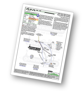
Cairn Gorm Ski Centre - Shieling Station - Fiacaill a' Choire Chais - Cairn Gorm (Cairngorms) - Ptarmigan Station - Sron An Aonaich - Cairn Gorm Ski Centre
|
Vital Statistics:
| Length: | 4.75 miles (7.5 km) |
| Ascent: | 197ft (60m) |
| Time: | 2 hrs |
| Grade: |  |
Route Summary:
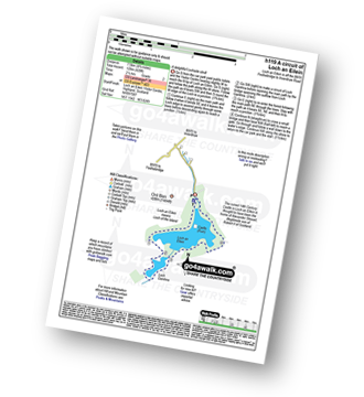
Loch An Eilein Visitor Centre - Rothiemurchus Loch an Eilein - Loch Gamhna - Loch An Eilein Visitor Centre - Rothiemurchus.
|
Vital Statistics:
| Length: | 5.25 miles (8.5 km) |
| Ascent: | 1,666ft (508m) |
| Time: | 3.75hrs |
| Grade: | |

Route Summary:
Glenmore Forest Park Visitor Centre - Meall a' Bhuachaille - Ryvoan Bothy - An Lochan Uaine - Glenmore Lodge - Glenmore Forest Park Visitor Centre
|
Vital Statistics:
| Length: | 7.25 miles (11.5 km) |
| Ascent: | 2,609ft (795m) |
| Time: | 5.25hrs |
| Grade: |  |

Route Summary:
Cairn Gorm Ski Centre - Shieling Station - Fiacaill a' Choire Chais - Stob Coire an t-Sneachda (Cairn Gorm) - Fiacaill Choire an t-Sneachda - Cairn Lochan - Miadan Creag An Lech-choin - Creag An Leth-choin (Lurcher's Crag) - Cairn Gorm Ski Centre
|
Vital Statistics:
| Length: | 8.75 miles (14 km) |
| Ascent: | 3,036ft (925m) |
| Time: | 6.25hrs |
| Grade: | |

Route Summary:
Cairn Gorm Ski Centre - Sron An Aonaich - Ptarmigan Station - Cnap Coire na Spreidhe (Cairn Gorm) - Cairn Gorm (Cairngorms) - Coire Cas - Fiacaill a' Choire Chais - Stob Coire an t-Sneachda (Cairn Gorm) - Fiacaill Choire an t-Sneachda - Cairn Lochan - Miadan Creag An Lech-choin - Creag An Leth-choin (Lurcher's Crag) - Cairn Gorm Ski Centre
|
Vital Statistics:
| Length: | 15 miles (24 km) |
| Ascent: | 3,052ft (930m) |
| Time: | 8½ hrs |
| Grade: | |
Route Summary:
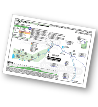
Glenmore Lodge - Allt na Feithe Duibhe - An Lochan Uaine - Ryvoan Pass - River Nethy - Bynack Stable - Bynack More - Little Barns of Bynack - A' Choinneach (Bynack More) - Allt a' Choire Dherg - Bynack Beg (Bynack More) - Strath Nethy - Bynack Stable - Ryvoan Pass - Glenmore Lodge
|
Vital Statistics:
| Length: | 11 miles (17.5 km) |
| Ascent: | 1,159ft (353m) |
| Time: | 5 hrs |
| Grade: |  |

Route Summary:
Glenmore Lodge - Allt na Feithe Duibhe - An Lochan Uaine - Ryvoan Pass - Loch a' Gharbh-choire - Bynack Stable - River Nethy - Abernethy Forest - Ryvoan Bothy - Ryvoan Pass - Glenmore Lodge
|
Vital Statistics:
| Length: | 10 miles (16 km) |
| Ascent: | 2,425ft (739m) |
| Time: | 6 hrs |
| Grade: | |

Route Summary:
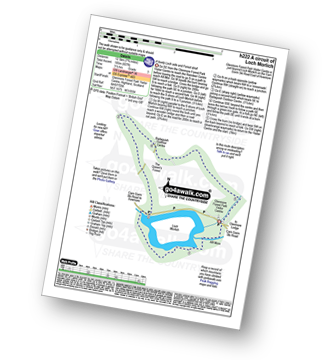
Glenmore Forest Park Visitor Centre - Glenmore Lodge - Allt na Feithe Duibhe - An Lochan Uaine - Ryvoan Pass - Ryvoan Bothy - Meall a' Bhuachaille - Creagan Gorm - Coire Beag-ghleann - Creag a' Chaillich - Craiggowrie - The Queen's Forest - Badaguish - Loch Morlich - Glenmore Forest Park Visitor Centre
|
Vital Statistics:
| Length: | 8.25 miles (13 km) |
| Ascent: | 745ft (244m) |
| Time: | 3.75hrs |
| Grade: | |
Route Summary:
Glenmore Forest Park Visitor Centre - Abhainn Ruigh-eunachan - Loch Morlich - River Luineag - The Queen's Forest - Badaguish Outdoor Centre - Glenmore Forest Park Visitor Centre
See this list of walks, routes & maps in:
Grade Order | Length Order | Time Order | Walk Number or Start Location Order
NB. To reverse (toggle) this order, click Grade Order again


