17 easy-to-follow walk, route maps of all grades on OS Explorer Map 241 Shrewsbury
Seventeen easy-to-follow walk, route maps of all grades on OS Explorer Map 241 Shrewsbury in Walk Grade OrderTap/mouse over a coloured circle (1-3 easy walks, 4-6 moderate walks, 7-9 hard walks) and click to select.
You can use these checkboxes to show only the grades of walk you are interested in:-
Seventeen easy-to-follow walk, route maps of all grades on OS Explorer Map 241 Shrewsbury in Walk Grade Order
Scroll down the list of walks below & click on each walk title (in blue) to locate it on the map above.
See this list of walks, routes & maps in:
Grade Order | Length Order | Time Order | Walk Number or Start Location Order
NB. To reverse (toggle) this order, click Grade Order again
   |
Vital Statistics:
| Length: | 5.5 miles (9 km) |
| Ascent: | 295ft (90m) |
| Time: | 2½ hrs |
| Grade: |  |
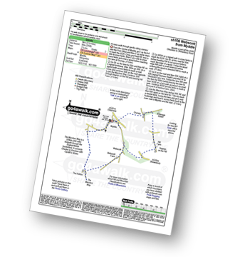
Route Summary:
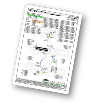
Myddle - Myddle Hill - Grumpy - Hill Farm - Newton on the Hill - Webscott - The Hollins - Myddle
|
Vital Statistics:
| Length: | 6.25 miles (10 km) |
| Ascent: | 295ft (90m) |
| Time: | 2½ hrs |
| Grade: | |
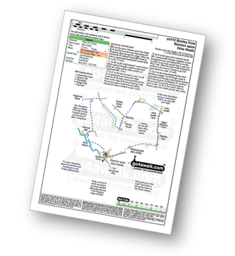
Route Summary:
Stanton Upon Hine Heath - The Shropshire Way - River Roden - Harcourt Mill - Paperbank Mill - Hardcourt Farm - The Woodlands - Booley - Old Shop Farm - Quarry Coppice - Megan's Coppice - Hine Heath - Hine Heath Farm - Upper Blakeley Farm - Blakeley Stud - Blakeleyhill - Stanton Upon Hine Heath
|
Vital Statistics:
| Length: | 4.75 miles (7.5 km) |
| Ascent: | 295ft (90m) |
| Time: | 2 hrs |
| Grade: | |

Route Summary:
Uffington - Haughmond Hill (Forest Commisison) - The Hollies - Haughmond Abbey - Abbey Wood - Haughmond Farm - New Coppice - Haughmond Hill (Forest Commisison) - Uffington
|
Vital Statistics:
| Length: | 8.75 miles (14 km) |
| Ascent: | 578ft (176m) |
| Time: | 3.75hrs |
| Grade: |  |
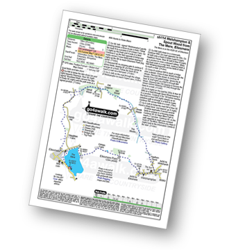
Route Summary:
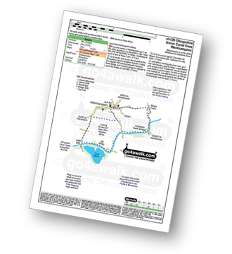
The Mere - Ellesmere - Crimps�Farm - Ellesmere Point - Welshampton - Hawthorn House - The Stocks - Brook House - Mill Wood - Old Coppice - Spout Wood - Sandy Hall - Haughton Farm - The Mere - Ellesmere.
|
Vital Statistics:
| Length: | 7.75 miles (12.5 km) |
| Ascent: | 1,083ft (330m) |
| Time: | 4 hrs |
| Grade: |  |
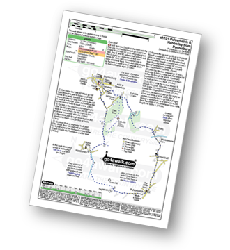
Route Summary:
Pontesbury - Oaks Wood - The Marches Way - Oaks - Wrentnall - Pulverbatch - Habberley - Pontesbury
|
Vital Statistics:
| Length: | 5 miles (8 km) |
| Ascent: | 197ft (60m) |
| Time: | 2 hrs |
| Grade: |  |
Route Summary:
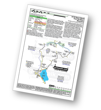
Welshampton - Rowe Farm - Shropshire Union Canal (Llangollen Branch) - Cole Mere - Welshampton
|
Vital Statistics:
| Length: | 6.5 miles (10.5 km) |
| Ascent: | 241ft (104m) |
| Time: | 2.75hrs |
| Grade: | |
Route Summary:
The Mere - Ellesmere - Crimps Cottage - Old Coptiviney - Coptiviney - Brook House - Mill Wood - Old Coppice - Spout Wood - Sandy Hall - Haughton Farm - The Mere - Ellesmere.
|
Vital Statistics:
| Length: | 9 miles (14.5 km) |
| Ascent: | 797ft (243m) |
| Time: | 4.25hrs |
| Grade: | |

Route Summary:
Corbet Wood - Grinshill - Clive - Grumpy - Myddle - The Marches Way - Webscott - Newton on the Hill - Yorton - Clive - Grinshill - The Shropshire Way - Corbet Wood - Grinshill
|
Vital Statistics:
| Length: | 9 miles (14.5 km) |
| Ascent: | 420ft (128m) |
| Time: | 3.75hrs |
| Grade: | |
Route Summary:
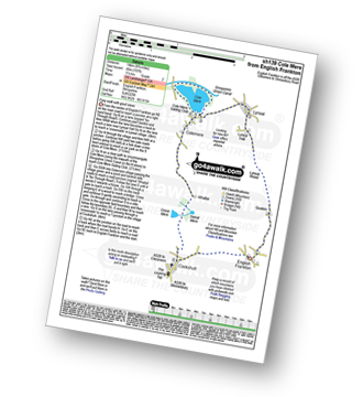
Cockshutt - English Frankton - Quaikin - Lyneal Wood - Lyneal Hall - River Roden - Lyneal - Cole Mere - Colemere - Whattal Farm - Whattal Moss - Seat Mere - Crose Mere - Lloyd's Wood - Crosemere House - Cockshutt,.
|
Vital Statistics:
| Length: | 7.5 miles (12 km) |
| Ascent: | 420ft (128m) |
| Time: | 3.25hrs |
| Grade: | |

Route Summary:
The Mere - Ellesmere - Crimps Farm - Ellesmere Point - Welshampton - Hawthorn House - The Stocks - Brook House - Stocks Farm - Coptiviney - Old Coptiviney - Crimps Cottage - The Mere - Ellesmere.
|
Vital Statistics:
| Length: | 5 miles (8 km) |
| Ascent: | 542ft (165m) |
| Time: | 2½ hrs |
| Grade: | |
Route Summary:
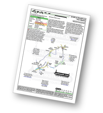
Weston - Wixhill - Lee Brockhurst - The Shropshire Way - Weston Heath Coppice - Weston Heath - Weston
|
Vital Statistics:
| Length: | 5 miles (8 km) |
| Ascent: | 161ft (49m) |
| Time: | 2 hrs |
| Grade: | |
Route Summary:
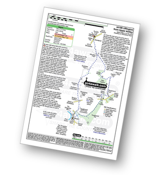
Upper Astley - The Shropshire Way - Wheatley Farm - Sunderton Farm - Sundorne Farm - Sundorne Castle Farm - Shrewsbury Rugby Club - New Coppice - Colin's Rough - Wheatley Farm - Upper Astley
|
Vital Statistics:
| Length: | 6 miles (9.5 km) |
| Ascent: | 351ft (107m) |
| Time: | 2½ hrs |
| Grade: | |
Route Summary:
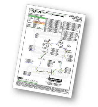
Grinshill - The Marches Way - Yorton Villa Farm - Yorton House Farm - Yorton Heath - Sansaw Heath - Sheepcotes - Sansaw Business Park - The Shropshire Way - Grinshill
|
Vital Statistics:
| Length: | 5.25 miles (8.5 km) |
| Ascent: | 459ft (140m) |
| Time: | 2½ hrs |
| Grade: | |

|
Vital Statistics:
| Length: | 7.5 miles (12 km) |
| Ascent: | 361ft (110m) |
| Time: | 3 hrs |
| Grade: | |
Route Summary:
Upper Astley - The Shropshire Way - Wheatley Farm - Sunderton Farm - Sundorne Farm - Sundorne Castle Farm - The River Severn - Uffington - Haughmond Hill (Forest Commisison) - The Hollies - Haughmond Abbey - Abbey Wood - Haughmond Farm - New Coppice - Colins Rough - Wheatley Farm - Upper Astley
|
Vital Statistics:
| Length: | 6.25 miles (10 km) |
| Ascent: | 558ft (170m) |
| Time: | 2.75hrs |
| Grade: | |

Route Summary:
Corbet Wood - Clive - Witterage Green - Newton On The Hill - Yorton - Grinshill - Corbet Wood
|
Vital Statistics:
| Length: | 9.25 miles (14.5 km) |
| Ascent: | 321ft (98m) |
| Time: | 3.75hrs |
| Grade: | |

Route Summary:
Loppington - Bentley Farm - Roden Farm - Brandwood Farm - Marton Coppice - Petton - Petton Hall - Petton Park - The Wood Farm - Woodgate Farm - Loppington
See this list of walks, routes & maps in:
Grade Order | Length Order | Time Order | Walk Number or Start Location Order
NB. To reverse (toggle) this order, click Grade Order again


