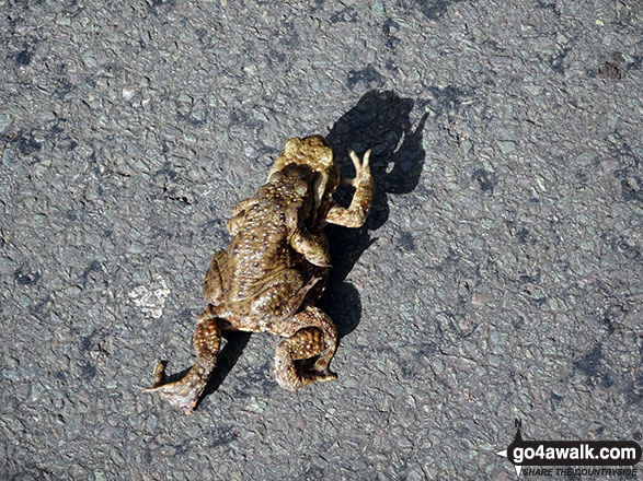
Toads crossing the road near Bowden Bridge, Hayfield
The White Peak Area,
The Peak District National Park,
Derbyshire, England
See views like this by using any of these 7 easy-to-follow circular walk route maps:
   |
Vital Statistics:
| Length: | 4.75 miles (7.5 km) |
| Ascent: | 843ft (257m) |
| Time: | 2.75hrs |
| Grade: |  |

Route Summary:
Hayfield - Sett Valley Trail Car Park - Valley Road - Bowden Bridge Car Park - Kinder Road - Kinder Reservoir - White Brow - Middle Moor (Hayfield) - Snake Path - Sett Valley Trail Car Park - Hayfield
|
Vital Statistics:
| Length: | 7.5 miles (12 km) |
| Ascent: | 1,808ft (551m) |
| Time: | 4½ hrs |
| Grade: |  |

Route Summary:
Bowden Bridge - Hayfield - Turnstead House - Coldwell Clough - Oaken Clough - Edale Cross - Brown Knoll (Edale) - South Head (Hayfield) - Mount Famine - Elle Bank - The Pennine Bridleway - Tunstead House - Bowden Bridge - Hayfield
|
Vital Statistics:
| Length: | 10.75 miles (17 km) |
| Ascent: | 2,242ft (683m) |
| Time: | 6.25hrs |
| Grade: |  |

Route Summary:
Bowden Bridge - Hayfield - Booth Sheepwash - Farlands - Broad Clough - Kinderlow End - Three Knolls - Cluther Rocks - Red Brook - The Pennine Way - Kinder Downfall - Kinder Low (Kinder Scout) - Brown Knoll (Edale) - South Head (Hayfield) - Mount Famine - Elle Bank - The Pennine Bridleway - Tunstead House - Hayfield
|
Vital Statistics:
| Length: | 8.75 miles (14 km) |
| Ascent: | 2,192ft (688m) |
| Time: | 5½ hrs |
| Grade: | |

Route Summary:
Bowden Bridge - Hayfield - Booth Sheepwash - White Brow - Kinder Reservoir - Nab Brow - William Clough - Ashop Head - Mill Hill (Ashop Head) - The Pennine Way - Kinder Scout - The Edge (Kinder Scout) - Kinder Downfall - Red Brook - Cluther Rocks - Kinder Low (Kinder Scout) - Edale Cross - Kinderlow End - Oaken Clough - Tunstead House Farm - Bowden Bridge - Hayfield
|
Vital Statistics:
| Length: | 10.5 miles (17 km) |
| Ascent: | 2,468ft (752m) |
| Time: | 6.25hrs |
| Grade: | |
Route Summary:
Hayfield - Sett Valley Trail - Birch Vale - Morland Road - Ollersett - New Allotments - Cracken Edge - Chinley Churn - Chinley Head - Dry Clough Farm - Chinley - Naze House - Greystead - Alder Ling - Wicken House - Andrews Farm - South Head (Hayfield) - Mount Famine - Elle Bank - Pennine Bridleway - Tunstead House - Bowden Bridge - Hayfield
|
Vital Statistics:
| Length: | 8.75 miles (14 km) |
| Ascent: | 1,851ft (564m) |
| Time: | 5 hrs |
| Grade: | |
Route Summary:
Bowden Bridge - Hayfield - Booth Sheepwash - Farlands - Broad Clough - Kinderlow End - Three Knolls - Cluther Rocks - Red Brook - The Pennine Way - Kinder Downfall - Kinder Low (Kinder Scout) - Edale Cross - Oaken Clough - Coldwell Clough - Bowden Bridge - Hayfield
|
Vital Statistics:
| Length: | 13.5 miles (21.5 km) |
| Ascent: | 2,914ft (888m) |
| Time: | 7.75hrs |
| Grade: |  |
Route Summary:
Hayfield - Sett Valley Trail - Birch Vale - Morland Road - Ollersett - New Allotments - Chinley Head - Mount Famine - South Head (Hayfield) - Brown Knoll (Edale) - Edale Cross - Oaken Clough - Coldwell Clough - Tunstead House - Bowden Bridge - Hayfield
Send us your photographs and pictures of walks and hikes in the British countryside
If you would like to see your digital photographs as part of this collection, please send them as email attachments (configured for any computer) along with your name to:
and we shall do our best to publish them.
(Guide Resolution = 300dpi. At least = 587 pixels (wide) x 440 pixels (high).)

You can also submit photos via our Facebook Page.
NB. Please indicate where each photo was taken.
NB. To see photographs and pictures from a particular walk choose your walk from Walks or use our Walk Search facility.
To see photographs and pictures on, of or from a particular Mountain, Peak, Top or Hill select from Peaks & Mountains' or enter the Mountain, Peak, Top or Hill Name into our 'Photo Search facility.


