Two easy to follow pub walks from The Kings Head, Kettlewell, The Yorkshire Dales, North Yorkshire, England
To reach The Kings Head, Kettlewell, in-car SatNav users should select the Latitude/Longitude (Lat Lon) screen and enter:
Lat = N54.14650 and Lon = W 2.0462
Tap/mouse over a coloured circle (1-3 easy walks, 4-6 moderate walks, 7-9 hard walks) and click to select.
Tap/mouse over a coloured circle (1-3 easy walks, 4-6 moderate walks, 7-9 hard walks) and click to select.
Two easy to follow pub walks from The Kings Head, Kettlewell, The Yorkshire Dales, North Yorkshire, England
Scroll down the list of walks below & click on each walk title (in blue) to locate it on the map above.
   |
Vital Statistics:
| Length: | 6.5 miles (10.5 km) |
| Ascent: | 1,476ft (450m) |
| Time: | 3.75hrs |
| Grade: |  |
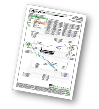
Route Summary:
Kettlewell - River Wharfe - New Bridge - Gate Cote Scar - Middlesmoor Pasture - Byre Bank Wood - Arncliffe - River Skirfare - Hawkswick - Knipe Wood - Kettlewell
|
Vital Statistics:
| Length: | 10 miles (16 km) |
| Ascent: | 1,771ft (540m) |
| Time: | 5½ hrs |
| Grade: |  |
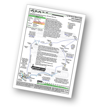
Route Summary:
Kettlewell - Dowber Gill Beck - Providence Pot - Hag Dyke (hostel) - Great Whernside - Black Hole Dike - Nidd Head - Little Hunters Sleet - Tor Dyke - Starbotton Road - Top Mere Road - Kettlewell


