Two easy to follow pub walks from Eyre Arms, Calver, The Peak District, Derbyshire, England
To reach Eyre Arms, Calver, in-car SatNav users should select the Latitude/Longitude (Lat Lon) screen and enter:
Lat = N53.27016 and Lon = W 1.64233
Tap/mouse over a coloured circle (1-3 easy walks, 4-6 moderate walks, 7-9 hard walks) and click to select.
Tap/mouse over a coloured circle (1-3 easy walks, 4-6 moderate walks, 7-9 hard walks) and click to select.
Two easy to follow pub walks from Eyre Arms, Calver, The Peak District, Derbyshire, England
Scroll down the list of walks below & click on each walk title (in blue) to locate it on the map above.
   |
Vital Statistics:
| Length: | 5.5 miles (8.5 km) |
| Ascent: | 869ft (265m) |
| Time: | 3 hrs |
| Grade: |  |
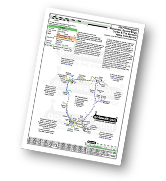
Route Summary:
Baslow - Over End - Wellington's Monument - Eagle Stone - Eaglestone Flat - Baslow Edge - Curbar - Calver - The Derwent Valley Heritage Way - River Derwent - Bridge End - Baslow
|
Vital Statistics:
| Length: | 9.5 miles (15 km) |
| Ascent: | 1,792ft (546m) |
| Time: | 5.25hrs |
| Grade: |  |
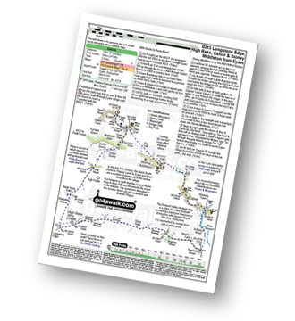
Route Summary:
Eyam - Eyam Dale - Middleton Dale - Dalton Quarry - High Fields - Black Harry Lane - Black Harry Gate - Blakedon Hollow - Longstone Edge - High Rake - Deep Rake - Bramley Wood - Bramley Farm - Townend Wood - The Dane Valley Heritage Way - St Mary's Wood - Calver - Stoney Middleton - The Cliff - Eyam


