Six easy to follow pub walks from The Peacock, Bakewell, The Peak District, Derbyshire, England
To reach The Peacock, Bakewell, in-car SatNav users should select the Latitude/Longitude (Lat Lon) screen and enter:
Lat = N53.21367 and Lon = W 1.67341
Tap/mouse over a coloured circle (1-3 easy walks, 4-6 moderate walks, 7-9 hard walks) and click to select.
Tap/mouse over a coloured circle (1-3 easy walks, 4-6 moderate walks, 7-9 hard walks) and click to select.
Six easy to follow pub walks from The Peacock, Bakewell, The Peak District, Derbyshire, England
Scroll down the list of walks below & click on each walk title (in blue) to locate it on the map above.
   |
Vital Statistics:
| Length: | 4.75 miles (7.5 km) |
| Ascent: | 230ft (70m) |
| Time: | 2 hrs |
| Grade: |  |

Route Summary:
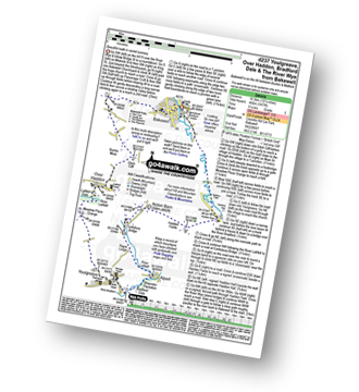
Bakewell - River Wye - Haddon Park - Haddon Hall - Haddon Fields - Wigger Dale - Burton Ashes Wood - Bakewell
|
Vital Statistics:
| Length: | 9.5 miles (15 km) |
| Ascent: | 1,332ft (406m) |
| Time: | 4.75hrs |
| Grade: |  |

Route Summary:
Bakewell - Noton Barn Farm - Noton Barn - Over Haddon - Bole Hill (Bakewell) - Kirk Dale - Sheldon - Great Shackleton Wood - River Wye - Ashford In The Water - River Wye - Holme Bridge - Bakewell
|
Vital Statistics:
| Length: | 10.25 miles (16.5 km) |
| Ascent: | 1,477ft (450m) |
| Time: | 5.25hrs |
| Grade: | |
Route Summary:
Bakewell - All Saints Church - Burton Moor - Ditch Cliff - Over Haddon - River Lathkill - Lathkill Dale - Meadow Place Grange - Youlgreave - River Bradford - Bradford Dale - River Lathkill - Lathkill Dale - Conksbury Bridge - Noton Barn - Haddon Fields - Haddon Barn - Haddon Park - River Wye - Bakewell
|
Vital Statistics:
| Length: | 9.5 miles (15 km) |
| Ascent: | 1,273ft (388m) |
| Time: | 4.75hrs |
| Grade: | |

Route Summary:
Bakewell - Castle Hill - Ballcross Farm - Edensor - River Derwent - Queen Mary's Bower - The Derwent Valley Heritage Way - Chatsworth Park - Calton Lees - Bank Wood - Rowsley - Bouns Corner - Aaron Hole Plantation - Shadyside Plantation - Haddon Park - River Wye - Wye Valley - Bakewell
|
Vital Statistics:
| Length: | 9 miles (14.5 km) |
| Ascent: | 1,257ft (383m) |
| Time: | 5 hrs |
| Grade: | |
Route Summary:
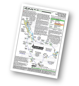
Bakewell - River Wye - Haddon Park - Shadyside Plantation - Aaron Hole Plantation - Bouns Corner - Rowsley - Congreave Farm - Smithy Wood - Stanton In The Peak - Tolls Wood - Shiningbank Quarry - Haddon Fields - Wigger Dale - Burton Ashes Wood - Bakewell
|
Vital Statistics:
| Length: | 10 miles (16 km) |
| Ascent: | 1,578ft (481m) |
| Time: | 5.25hrs |
| Grade: |  |

Route Summary:
Bakewell - The Monsal Trail - Hassop Station. Great Longstone Station - Little Longstone - Monsal Head - Monsal Dale - River Wye - Great Shackleton Wood - Magpie Sough - Ashford In The Water - River Wye - Holme Bridge - Bakewell


