Unclassified Icon

Noton Barn
208m (682ft)


The White Peak Area, The Peak District, Derbyshire, England

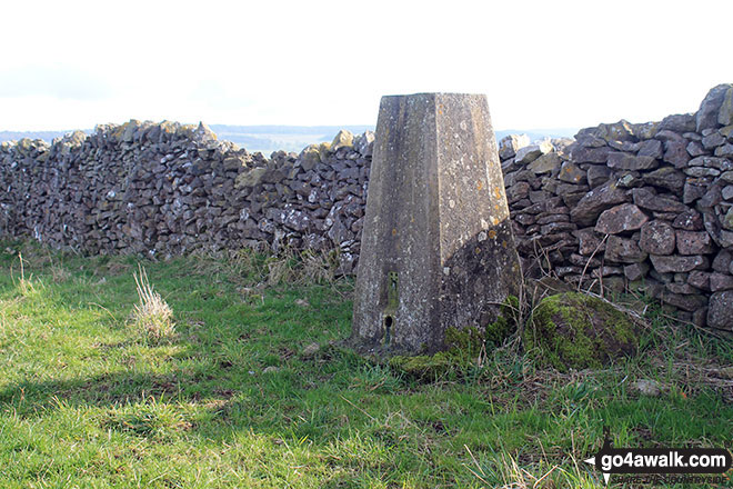
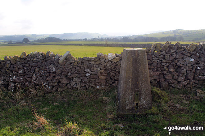
The summit of Noton Barn is on private farmland.

The summit of Noton Barn is marked by an Ordnance Survey Trig Point.


Record Noton Barn as Bagged, Climbed & Conquered

English Trig Point Icon


English Trig Point (Pillar)

Walk Noton Barn walking UK Mountains in The White Peak Area The Peak District National Park Derbyshiren, England

Noton Barn Summit

Photo: Christopher Park


Not familiar with this top?

How is Noton Barn classified?

Download 2 easy-to-follow, circular walks that climb Noton Barn

See the location of Noton Barn and both walks on an interactive Google Map

See the location of Noton Barn on an interactive Google Bagging Map

See downloadable Bagging Map in PDF format that includes Noton Barn

Read walk reports from hikers who have already bagged Noton Barn

View more photographs & pictures of views from, on or of Noton Barn


You can walk to the top of Noton Barn by using either of these 2 easy‑to‑follow route maps:
Walking Boot Print Icon

Walk d154 Over Haddon, Sheldon and Ashford in the Water from Bakewell

A lovely walk

Walk GPS Icon
Walk GPX Icon
Walk PDF Icon

Vital Statistics:

Length: 9.5ml (15km)
Ascent:1,332ft (406m)
Time:4.75hrs
Grade:Walk Grade 5 Icon (Moderate)
Walking Boot Print Icon

Walk d237 Youlgreave, Over Haddon, Bradford Dale and The River Wye from Bakewell

Beautiful walk in varied scenery

Walk GPS Icon
Walk GPX Icon
Walk PDF Icon

Vital Statistics:

Length: 10.25ml (16.5km)
Ascent:1,477ft (450m)
Time:5.25hrs
Grade:Walk Grade 5 Icon (Moderate)

See Noton Barn and the surrounding tops on our free-to-access 'Google Style' Peak Bagging Maps:

Find Google Maps Peak Bagging Map Icon

The Peak District National Park

Find Google Maps Peak Bagging Map Icon

The White Peak Area of The Peak District National Park


See Noton Barn and the surrounding tops on our downloadable Peak Bagging Map in PDF format:

Find PDF Peak Bagging Map Icon

-The White Peak Area of The Peak District National Park

NB: Whether you print off a copy or download it to your phone, this PDF Peak Baggers' Map might prove incredibly useful when your are up there on the tops and you cannot get a phone signal.


You can find Noton Barn & all the walks that climb it on these unique free-to-access Interactive Walk Planning Maps:

The Peak District National Park


1:25,000 scale OS Explorer Map (orange/yellow covers):

OS Explorer OL24 The Peak District - White Peak area


1:50,000 scale OS Landranger Map (pink/magenta covers):

OS Landranger 119 Buxton & Matlock, Bakewell & Dove Dale


There are no walk reports for Noton Barn because it is on private land and not accessible to the public

More Photographs & Pictures of views from, on or of Noton Barn

The view from the trig point on Noton Barn

The view from the trig point on Noton Barn

Photo: Christopher Park (10)

Noton Barn from Noton Barn Farm

Noton Barn from Noton Barn Farm

Photo: Christopher Park (9)

Bakewell from the summit of Noton Barn

Bakewell from the summit of Noton Barn

Photo: Christopher Park (12)

Noton Barn trig point

Noton Barn trig point

Photo: Terry Howard (168)


Send us your photographs and pictures on, of, or from Noton Barn

If you would like to add your walk photographs and pictures featuring views from, on or of Noton Barn to this page, please send them as email attachments (configured for any computer) along with your name to:


and we shall do our best to publish them.

(Guide Resolution = 300dpi. At least = 660pixels (wide) x 440 pixels (high).)

Send us your photographs and pictures on, of, or from Noton Barn via Facebook

You can also submit photos via our Facebook Page.

NB. Please indicate where each photo was taken.


Not familiar with this top?

How is Noton Barn classified?

Download 2 easy-to-follow, circular walks that climb Noton Barn

See the location of Noton Barn and both walks on an interactive Google Map

See the location of Noton Barn on an interactive Google Bagging Map

See downloadable Bagging Map in PDF format that includes Noton Barn

Read walk reports from hikers who have already bagged Noton Barn

View more photographs & pictures of views from, on or of Noton Barn


Do not miss our pick of the Best Walks in Britain


Follow go4awalk.com on Twitter Follow go4awalk.com on Facebook


Home


Find new Friends to go walking with

Walk all 214 Wainwrights in just 59 Walks. Download GPS Waypoints - Great Walks you must not miss!

Walk The Yorkshire Three Peaks Challenge Walk - All the Latest Route Information, GPS Waypoints and Split Times to keep you on Schedule

Walk The British Three Peaks Challenge Walk - All the Latest Route Information and GPS Waypoints

See our pick of The Best Walks in The Lake District - Great Walks you must not miss!

Walk our pick of the Best Lake District Ridge Walks - Great Walks you must not miss!

Walk our pick of the Best Lake District Walks to do in the rain - Great Walks you must not miss!

Walk our pick of The Best Walks in Snowdonia - Great Walks you must not miss!

Walk our pick of The Best Ridge Walks in Wales - Walks you must not miss!

Walk our pick of The Best Walks in The Brecon Beacons - Great Walks you must not miss!

Walk our pick of The Best Walks in The Yorkshire Dales - Walks you must not miss!

Walk our pick of The Best Walks in The Peak District - Walks you must not miss!

Walk our pick of The Best Walks in The Forest of Bowland - Walks you must not miss!

Walk our pick of The Best Walks in Shropshire - Walks you must not miss!

Walk our pick of The Best Walks in Cheshire - Walks you must not miss!

Walk our pick of The Best Walks in Lancashire - Walks you must not miss!

Not sure where to walk next? Try Peak Bagging - Great Walks you must not miss!

Not sure where to walk next? Walk part of a National Trail - Great Walks you must not miss!

Walks with Downloadable and Uploadable GPS Waypoint Data

Walking Kit and Gear Tested by Walkers

Full Site Search
Do not miss our pick of the Best Walks in Britain