Two easy to follow pub walks from The Greyfriar, Chawton, The South Downs, Hampshire, England
To reach The Greyfriar, Chawton, in-car SatNav users should select the Latitude/Longitude (Lat Lon) screen and enter:
Lat = N51.13310 and Lon = W 0.9887
Tap/mouse over a coloured circle (1-3 easy walks, 4-6 moderate walks, 7-9 hard walks) and click to select.
Tap/mouse over a coloured circle (1-3 easy walks, 4-6 moderate walks, 7-9 hard walks) and click to select.
Two easy to follow pub walks from The Greyfriar, Chawton, The South Downs, Hampshire, England
Scroll down the list of walks below & click on each walk title (in blue) to locate it on the map above.
   |
Vital Statistics:
| Length: | 5.5 miles (8.5 km) |
| Ascent: | 263ft (80m) |
| Time: | 2.25hrs |
| Grade: |  |
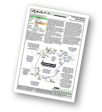
Route Summary:
Chawton - Alton - Jane Austen's House Museum - The St Swithun's Way - Lower Farringdon - Upper Farringdon - Caker Stream - Round Groves Copse - Peck Copse - Shepherd's Court - Eastfield Farm - Chawton
|
Vital Statistics:
| Length: | 7.5 miles (12 km) |
| Ascent: | 673ft (205m) |
| Time: | 3.75hrs |
| Grade: |  |

Route Summary:
Chawton - Alton - Jane Austen's House Museum - The St Swithun's Way - Park Cottage - Upper Woodside Farm - New Copse - Dell Piece - Weathermore Copse - Medstead and Four Marks - Watercress Railway Line - Chawton Park Wood - Alton - Chawton


