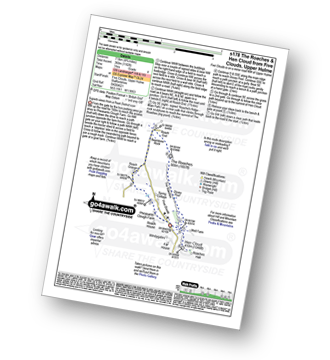
Six easy to follow pub walks from Ye Olde Rock Inn, Upper Hulme, The Peak District, Staffordshire, England
To reach Ye Olde Rock Inn, Upper Hulme, in-car SatNav users should select the Latitude/Longitude (Lat Lon) screen and enter:
Lat = N53.14604 and Lon = W 1.98154
Tap/mouse over a coloured circle (1-3 easy walks, 4-6 moderate walks, 7-9 hard walks) and click to select.
Tap/mouse over a coloured circle (1-3 easy walks, 4-6 moderate walks, 7-9 hard walks) and click to select.
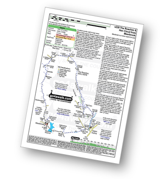
Six easy to follow pub walks from Ye Olde Rock Inn, Upper Hulme, The Peak District, Staffordshire, England
Scroll down the list of walks below & click on each walk title (in blue) to locate it on the map above.
   |
Vital Statistics:
| Length: | 3.75 miles (6 km) |
| Ascent: | 775ft (236m) |
| Time: | 2.25hrs |
| Grade: |  |

Route Summary:
Five Clouds - Upper Hulme - Rockhall - Doxey Pool - The Roaches - Roach End - Spring Cottage - Five Clouds - Upper Hulme
|
Vital Statistics:
| Length: | 6 miles (9.5 km) |
| Ascent: | 1,234ft (376m) |
| Time: | 3½ hrs |
| Grade: |  |

Route Summary:
Five Clouds - Upper Hulme - Rockhall - The Roaches - Roach End - Back Forest - Lud's Church - Rock Chasm - Forest Wood - Roach End - Spring Cottage - Five Clouds - Upper Hulme
|
Vital Statistics:
| Length: | 4.75 miles (7.5 km) |
| Ascent: | 1,182ft (360m) |
| Time: | 3 hrs |
| Grade: | |
Route Summary:
Five Clouds - Pheasants Clough Farm - Roach Grange - Roach End - Bearstone Rock - The Roaches - Doxey Pool - Rockhall - Hen Cloud - Rockhall - Five Clouds
|
Vital Statistics:
| Length: | 8.25 miles (13 km) |
| Ascent: | 1,490ft (454m) |
| Time: | 4½ hrs |
| Grade: |  |
Route Summary:
Meerbrook - Lea End - Stockmeadows Farm - Meadows Farm - Buxton Brow Farm - Clough Head - Roach End - Bearstone Rock - The Roaches - Doxey Pool - Rockhall - Hen Cloud - Rockhall - Well Farm - Dains Mill - Upper Hulme - Butty Fold Farm - Tittesworth Reservoir - Meerbrook
|
Vital Statistics:
| Length: | 11.5 miles (18.5 km) |
| Ascent: | 2,274ft (693m) |
| Time: | 6½ hrs |
| Grade: |  |

Route Summary:
Gradbach - The Dane Valley Way - Gradbach Youth Hostel - Black Brook - Forest Wood - Roach End - The Roaches - Doxey Pool - Rockhall - Hen Cloud - Well Farm - Dains Mill - Upper Hulme - Butty Fold Farm - Staffordshire Moorlands Walk - Tittesworth Reservoir - Meerbrook - Stockmeadows Farm - Meadows Farm - Buxton Brow - Clough Head - Back Forest - Lud's Church - Rock Chasm - Black Brook - Gradbach Youth Hostel - The Dane Valley Way - Gradbach
|
Vital Statistics:
| Length: | 9 miles (14.5 km) |
| Ascent: | 1,795ft (547m) |
| Time: | 5 hrs |
| Grade: | |

Route Summary:
Upper Hulme - Dains Mill - Blue Hills - Black Brook Nature Reserve - Gib Torr Rocks - Moss Top - Moss End Farm - Black Brook - Roach End - The Roaches - Rockhall - Hen Cloud - Roaches Hall - Upper Hulme


