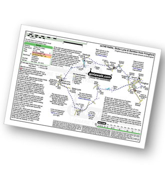
Two easy to follow pub walks from The Peyton Arms, Stoke Lyne, Oxfordshire, England
To reach The Peyton Arms, Stoke Lyne, in-car SatNav users should select the Latitude/Longitude (Lat Lon) screen and enter:
Lat = N51.95181 and Lon = W 1.17739
Tap/mouse over a coloured circle (1-3 easy walks, 4-6 moderate walks, 7-9 hard walks) and click to select.
Tap/mouse over a coloured circle (1-3 easy walks, 4-6 moderate walks, 7-9 hard walks) and click to select.
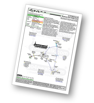
Two easy to follow pub walks from The Peyton Arms, Stoke Lyne, Oxfordshire, England
Scroll down the list of walks below & click on each walk title (in blue) to locate it on the map above.
   |
Vital Statistics:
| Length: | 5.25 miles (8.5 km) |
| Ascent: | 177ft (54m) |
| Time: | 2.25hrs |
| Grade: |  |
Route Summary:
Stoke Wood - Stoke Lyne - Bainton - Hardwick Ford - Hardwick - Stoke Bushes - Stoke Lyne - Stoke Wood
|
Vital Statistics:
| Length: | 7.75 miles (12.5 km) |
| Ascent: | 295ft (90m) |
| Time: | 3.25hrs |
| Grade: |  |