Two easy to follow pub walks from The Turks Head Inn, Alston, Cumbria, England
To reach The Turks Head Inn, Alston, in-car SatNav users should select the Latitude/Longitude (Lat Lon) screen and enter:
Lat = N54.81266 and Lon = W 2.43865
Tap/mouse over a coloured circle (1-3 easy walks, 4-6 moderate walks, 7-9 hard walks) and click to select.
Tap/mouse over a coloured circle (1-3 easy walks, 4-6 moderate walks, 7-9 hard walks) and click to select.
Two easy to follow pub walks from The Turks Head Inn, Alston, Cumbria, England
Scroll down the list of walks below & click on each walk title (in blue) to locate it on the map above.
   |
Vital Statistics:
| Length: | 4.75 miles (7.5 km) |
| Ascent: | 479ft (146m) |
| Time: | 2.25hrs |
| Grade: |  |
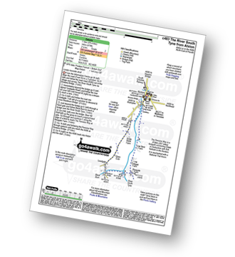
Route Summary:
Alston - Leadgate - Blackburn Bridge - Bleagate Farm - The Pennine Way - Low Nest Farm - Alston
|
Vital Statistics:
| Length: | 8.75 miles (14 km) |
| Ascent: | 798ft (243m) |
| Time: | 4 hrs |
| Grade: |  |
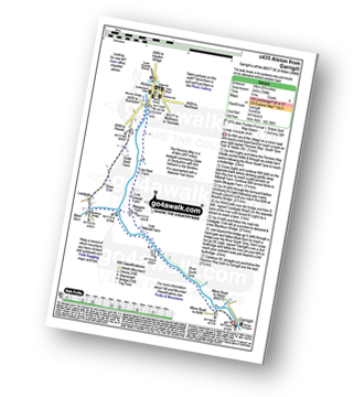
Route Summary:
Garrigill - The Pennine Way - The South Tyne Trail - The River South Tyne - Low Sillyhall Farm - Bleagate Farm - Low Cowgap Farm - Low Nest Farm - Brewery Bridge - Alston - Crosslands - Leadgate - Blackburn Bridge - Garrigill


