Four easy to follow pub walks from The Newfield Inn, Seathwaite (Duddon Valley), Cumbria, England
To reach The Newfield Inn, Seathwaite (Duddon Valley), in-car SatNav users should select the Latitude/Longitude (Lat Lon) screen and enter:
Lat = N54.35365 and Lon = W 3.18988
Tap/mouse over a coloured circle (1-3 easy walks, 4-6 moderate walks, 7-9 hard walks) and click to select.
Tap/mouse over a coloured circle (1-3 easy walks, 4-6 moderate walks, 7-9 hard walks) and click to select.
Four easy to follow pub walks from The Newfield Inn, Seathwaite (Duddon Valley), Cumbria, England
Scroll down the list of walks below & click on each walk title (in blue) to locate it on the map above.
   |
Vital Statistics:
| Length: | 5.5 miles (9 km) |
| Ascent: | 1,706ft (520m) |
| Time: | 3.75hrs |
| Grade: |  |
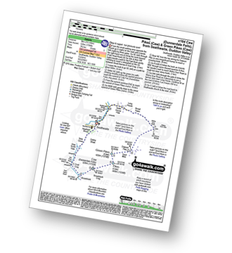
Route Summary:
Seathwaite (Duddon Valley) - Newfield Wood - Dobby Shaw - New Close - How Scale Haw - Old Park Beck - Broadslack - Caw (Dunnerdale Fells) - Pikes (Caw) - Green Pikes (Caw) - Dawson Pike - Walna Scar Road - Broad Haws - Hollin House Haw - Tarn Beck - Seathwaite (Duddon Valley)
|
Vital Statistics:
| Length: | 6.5 miles (10.5 km) |
| Ascent: | 1,453ft (443m) |
| Time: | 4 hrs |
| Grade: | |

Route Summary:
Seathwaite (Duddon Valley) - Hollin House Haw - Tarn Beck - Worm How - Trountal Tongue - Throng Close - Foss How - Brow Side - Pike How - Birks Bridge - Birks Farm Field Centre - Dunnerdale Forest - Grassguards Farm - Basin Barrow - Rowantree How - Wallowbarrow Crag - Wallowbarrow Farm - Seathwaite (Duddon Valley)
|
Vital Statistics:
| Length: | 7 miles (11 km) |
| Ascent: | 2,422ft (738m) |
| Time: | 5 hrs |
| Grade: |  |
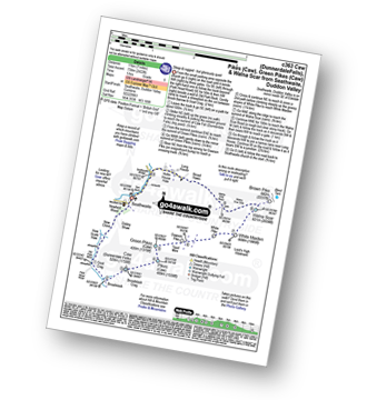
Route Summary:
Seathwaite (Duddon Valley) - Newfield Wood - Dobby Shaw - New Close - How Scale Haw - Old Park Beck - Broadslack - Caw (Dunnerdale Fells) - Pikes (Caw) - Green Pikes (Caw) - Dawson Pike - White Pike - White Maiden - Walna Scar - Walna Scar Road - Broad Haws - Hollin House Haw - Tarn Beck - Seathwaite (Duddon Valley)
|
Vital Statistics:
| Length: | 9.5 miles (15 km) |
| Ascent: | 3,523ft (1,074m) |
| Time: | 7 hrs |
| Grade: |  |

Route Summary:
Walna Scar Road (nr Seathwaite (Duddon Valley) - Long Houses - Brown Pike - Dow Crag - Goat's Hawse - The Old Man of Coniston - Brim Fell - Levers Hawse - Swirl Band - Swirl How - Great Carrs - Grey Friar - Seathwaite Tarn - Walna Scar Road.


