Two easy to follow pub walks from The Stephen Langton, Friday Street, Surrey, England
To reach The Stephen Langton, Friday Street, in-car SatNav users should select the Latitude/Longitude (Lat Lon) screen and enter:
Lat = N51.19839 and Lon = W 0.38695
Tap/mouse over a coloured circle (1-3 easy walks, 4-6 moderate walks, 7-9 hard walks) and click to select.
Tap/mouse over a coloured circle (1-3 easy walks, 4-6 moderate walks, 7-9 hard walks) and click to select.
Two easy to follow pub walks from The Stephen Langton, Friday Street, Surrey, England
Scroll down the list of walks below & click on each walk title (in blue) to locate it on the map above.
   |
Vital Statistics:
| Length: | 5.5 miles (9 km) |
| Ascent: | 768ft (234m) |
| Time: | 3 hrs |
| Grade: |  |
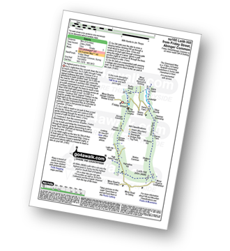
Route Summary:
Friday Street - Abinger Common - Abinger Bottom - The Greensand Way - Leith Hill - Shakes Hill - Whitberry Hill - Stable Copse - Bushy Wood - Friday Street
|
Vital Statistics:
| Length: | 6.25 miles (10 km) |
| Ascent: | 752ft (229m) |
| Time: | 3 hrs |
| Grade: | |

Route Summary:
Westcott - Mill Pond - The Greensand Way - Sylvanus Wood - Stable Copse - Bushy Wood - Friday Street - Tilling Bourne - Horsley Copse - Wotton - Vale Farm - Westcott


