Two easy to follow pub walks from The Royal Oak, Rushton Spencer, The Peak District, Staffordshire, England
To reach The Royal Oak, Rushton Spencer, in-car SatNav users should select the Latitude/Longitude (Lat Lon) screen and enter:
Lat = N53.15810 and Lon = W 2.09128
Tap/mouse over a coloured circle (1-3 easy walks, 4-6 moderate walks, 7-9 hard walks) and click to select.
Tap/mouse over a coloured circle (1-3 easy walks, 4-6 moderate walks, 7-9 hard walks) and click to select.
Two easy to follow pub walks from The Royal Oak, Rushton Spencer, The Peak District, Staffordshire, England
Scroll down the list of walks below & click on each walk title (in blue) to locate it on the map above.
   |
Vital Statistics:
| Length: | 5.5 miles (8.5 km) |
| Ascent: | 896ft (273m) |
| Time: | 3 hrs |
| Grade: |  |
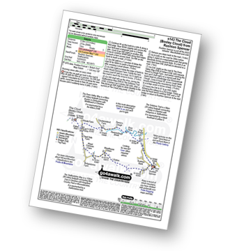
Route Summary:
Rushton Spencer - Oulton - Woodhouse Green - Wood Common Farm - Avona - The Staffordshire Way - The Gritstone Trail - The Cloud (Bosley Cloud) - Bosley Cloud - Avona - The Dane Valley Way - Raven's Clough - Ravensclough Brook - Rushton Spencer
|
Vital Statistics:
| Length: | 10 miles (16 km) |
| Ascent: | 1,404ft (428m) |
| Time: | 5 hrs |
| Grade: |  |

Route Summary:
Rudyard Reservoir - The Staffordshire Way - Ryecroft Gate - Rushton Spencer - Heaton Lodge Farm - Weathercock Farm - Gun End House - Gun (Staffordshire) - Fould Farm - Fould Villa - Poolend - Willgate Farm - Rudyard - Black Wood - Rudyard Reservoir


