Two easy to follow pub walks from The Brewers Arms, Martinstown, Dorset, England
To reach The Brewers Arms, Martinstown, in-car SatNav users should select the Latitude/Longitude (Lat Lon) screen and enter:
Lat = N50.69940 and Lon = W 2.5044
Tap/mouse over a coloured circle (1-3 easy walks, 4-6 moderate walks, 7-9 hard walks) and click to select.
Tap/mouse over a coloured circle (1-3 easy walks, 4-6 moderate walks, 7-9 hard walks) and click to select.
Two easy to follow pub walks from The Brewers Arms, Martinstown, Dorset, England
Scroll down the list of walks below & click on each walk title (in blue) to locate it on the map above.
   |
Vital Statistics:
| Length: | 7.25 miles (11.5 km) |
| Ascent: | 847ft (258m) |
| Time: | 3½ hrs |
| Grade: |  |
Route Summary:
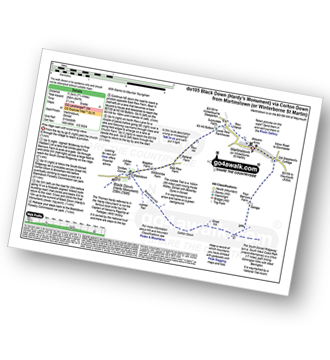
Martinstown (or Winterborne St Martin) - Four Barrows Farm - Great Hill - South Dorset Ridgeway - Corton Down - Bronkham Hill - Jubilee Trail - Blackdown - Smitten Corner - Black Down (Hardy Monument) - East Rew Farm - Rew Manor - Martinstown (or Winterboune St Martin).
|
Vital Statistics:
| Length: | 7 miles (11 km) |
| Ascent: | 1,037ft (316m) |
| Time: | 3½ hrs |
| Grade: | |

Route Summary:
Martinstown (or Winterborne St Martin) - Grove Hill Bottom - Great Hill - South Dorset Ridgeway - Corton Down - Bronkham Hill - Jubilee Trail - Blackdown - Smitten Corner - Black Down (Hardy Monument) - Bronkham Hill - Pen Barn Farm - Grove Hill Bottom - Martinstown (or Winterborne St Martin)


