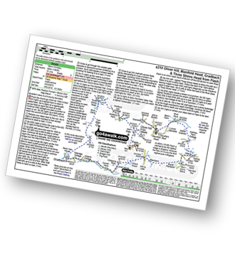
Two easy to follow pub walks from The Travellers Rest (Knights Table), Manifold Head, The Peak District, Staffordshire, England
To reach The Travellers Rest (Knights Table), Manifold Head, in-car SatNav users should select the Latitude/Longitude (Lat Lon) screen and enter:
Lat = N53.20739 and Lon = W 1.95347
Tap/mouse over a coloured circle (1-3 easy walks, 4-6 moderate walks, 7-9 hard walks) and click to select.
Tap/mouse over a coloured circle (1-3 easy walks, 4-6 moderate walks, 7-9 hard walks) and click to select.
Two easy to follow pub walks from The Travellers Rest (Knights Table), Manifold Head, The Peak District, Staffordshire, England
Scroll down the list of walks below & click on each walk title (in blue) to locate it on the map above.
   |
Vital Statistics:
| Length: | 5 miles (8 km) |
| Ascent: | 991ft (302m) |
| Time: | 2.75hrs |
| Grade: |  |

Route Summary:
Flash - Oliver Hill - Oxensitch - River Manifold Head - River Dove - Nether Colshaw Farm - Golling Gate Farm - Dun Cow's Grove Farm - The Manifold Trail - Blackbank Farm - Flash
|
Vital Statistics:
| Length: | 10 miles (16 km) |
| Ascent: | 1,953ft (595m) |
| Time: | 5.75hrs |
| Grade: |  |
Route Summary:
Flash - Oliver Hill - Oxensitch - River Manifold Head - River Dove - Nether Colshaw Farm - Golling Gate Farm - Dun Cow's Grove Farm - The Manifold Trail - Blackbank Farm - Wilson Knowl Farm - Lower House Farm - Culvert Farm - Tollbridge Cottage - Gradbach - The Dane Valley Way - Dane View House - River Dane - Three Shires Head - Panniers Pool - Knotbury Farm - Wolf Edge - Flash


