Four easy to follow pub walks from The Stanhope, Dunford Bridge, The Peak District, South Yorkshire, England
To reach The Stanhope, Dunford Bridge, in-car SatNav users should select the Latitude/Longitude (Lat Lon) screen and enter:
Lat = N53.51734 and Lon = W 1.76276
Tap/mouse over a coloured circle (1-3 easy walks, 4-6 moderate walks, 7-9 hard walks) and click to select.
Tap/mouse over a coloured circle (1-3 easy walks, 4-6 moderate walks, 7-9 hard walks) and click to select.
Four easy to follow pub walks from The Stanhope, Dunford Bridge, The Peak District, South Yorkshire, England
Scroll down the list of walks below & click on each walk title (in blue) to locate it on the map above.
   |
Vital Statistics:
| Length: | 5.5 miles (8.5 km) |
| Ascent: | 728ft (222m) |
| Time: | 2.75hrs |
| Grade: |  |
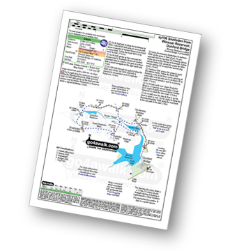
Route Summary:
Winscar Reservoir - Dunford Bridge - Harden Reservoir - Harden Clough - Cook's Study Hill - Snailsden Reservoir - Snailsden - Upper Snailsden Moss - Harden Clugh - Harden Reservoir - Winscar Reservoir - Dunford Bridge.
|
Vital Statistics:
| Length: | 5.25 miles (8.5 km) |
| Ascent: | 817ft (249m) |
| Time: | 2.75hrs |
| Grade: | |

Route Summary:
Winscar Reservoir - Dunford Bridge - The Barnsley Boundary Walk - Little Moor - The Trans Pennine Trail - The Longdendale Trail - Windle Edge - Upper Windleden Reservoir - Fiddlers Green - South Nab - Lady Cross - Salter's Brook Moss - Gallows Moss - Carr Top - Woodhead Railway Tunnel Air Shaft - Upper Grip Hill - Lower Grip Hill - Winscar Reservoir - Dunford Bridge.
|
Vital Statistics:
| Length: | 7.25 miles (11.5 km) |
| Ascent: | 896ft (273m) |
| Time: | 3.75hrs |
| Grade: |  |
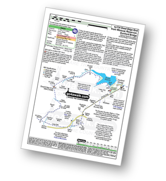
Route Summary:
Winscar Reservoir - Dunford Bridge - The Barnsley Boundary Walk - Little Moor - The Trans Pennine Trail - The Longdendale Trail - Windle Edge - Bagshaw Ridge - Gallows Moss - Salter's Brook Moss - Long Side (Woodhead) - Hawthorn Clough - Woodhead Railway Tunnel Air Shaft - Upper Head Dike - Dead Edge End - Upper Dead Edge - Grains Moss - Little Grains Clough - Winscar Reservoir - Dunford Bridge.
|
Vital Statistics:
| Length: | 12 miles (19 km) |
| Ascent: | 1,365ft (416m) |
| Time: | 5.75hrs |
| Grade: |  |
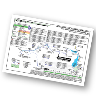
Route Summary:
Winscar Reservoir - Dunford Bridge - The Barnsley Boundary Walk - Little Moor - The Trans Pennine Trail - The Longdendale Trail - Windle Edge - Bagshaw Ridge - Gallows Moss - Salter's Brook Moss - Long Side - Hawthorn Clough - Woodhead Railway Tunnel Air Shaft - Upper Head Dike - Dead Edge End - Upper Dead Edge - Grains Moss - Withins Edge - Britland Edge Hill - Bleakmires Moss - Twizle Head Moss - Lad Clough Knoll - Ramsden Clough - Snailsden - Upper Snailsden Moss - Harden Clugh - Harden Reservoir - Winscar Reservoir - Dunford Bridge.


