Two easy to follow pub walks from The Bridge Inn, Amberley, The South Downs, West Sussex, England
To reach The Bridge Inn, Amberley, in-car SatNav users should select the Latitude/Longitude (Lat Lon) screen and enter:
Lat = N50.89683 and Lon = W 0.54291
Tap/mouse over a coloured circle (1-3 easy walks, 4-6 moderate walks, 7-9 hard walks) and click to select.
Tap/mouse over a coloured circle (1-3 easy walks, 4-6 moderate walks, 7-9 hard walks) and click to select.
Two easy to follow pub walks from The Bridge Inn, Amberley, The South Downs, West Sussex, England
Scroll down the list of walks below & click on each walk title (in blue) to locate it on the map above.
   |
Vital Statistics:
| Length: | 5.5 miles (9 km) |
| Ascent: | 630ft (192m) |
| Time: | 2½ hrs |
| Grade: |  |
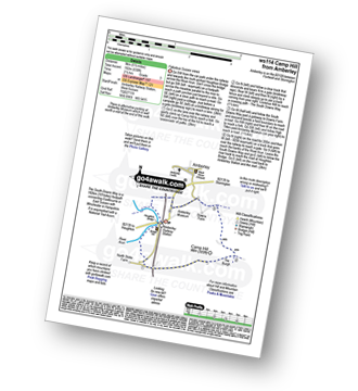
Route Summary:
Amberley Museum - Amberley Railway Station - Houghton Bridge - The River Arun - North Stoke - Camp Hill - The South Downs Way - High Titten - Foxleigh Down - The River Arun - Amberley.
|
Vital Statistics:
| Length: | 6.25 miles (10 km) |
| Ascent: | 660ft (201m) |
| Time: | 3 hrs |
| Grade: | |

Route Summary:
Amberley Museum - Amberley Railway Station - Houghton Bridge - The River Arun - North Stoke - Camp Hill - The South Downs Way - Amberley Village - Amberley Castle - The River Arun - Amberley.


