Three easy to follow pub walks from The Carpenters Arms, Polzeath, Cornwall, England
To reach The Carpenters Arms, Polzeath, in-car SatNav users should select the Latitude/Longitude (Lat Lon) screen and enter:
Lat = N50.57128 and Lon = W 4.91692
Tap/mouse over a coloured circle (1-3 easy walks, 4-6 moderate walks, 7-9 hard walks) and click to select.
Tap/mouse over a coloured circle (1-3 easy walks, 4-6 moderate walks, 7-9 hard walks) and click to select.
Three easy to follow pub walks from The Carpenters Arms, Polzeath, Cornwall, England
Scroll down the list of walks below & click on each walk title (in blue) to locate it on the map above.
   |
Vital Statistics:
| Length: | 5.5 miles (9 km) |
| Ascent: | 1,208ft (368m) |
| Time: | 3½ hrs |
| Grade: |  |

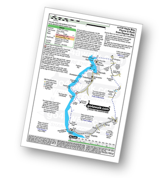
Route Summary:
Trebetherick - The South West Coast Path - Polzeath - New Polzeath - Slipper Point - Pentireglaze Haven - Pentire Point - Pentire Head - Guglane - Rumps Point - Sandinway Beach - Com Head - Pengrit Cove - Downhedge Cove - Pentireglaze - Polzeath - Trebetherick
|
Vital Statistics:
| Length: | 8.25 miles (13.5 km) |
| Ascent: | 958ft (292m) |
| Time: | 4 hrs |
| Grade: | |
Route Summary:
Daymer Bay (Trebetherick) - The South West Coast Path - Trebetherick Point - Greenaway Beach - Broadagogue Cove - Hayle Bay - Trebetherick - Polzeath - New Polzeath - Slipper Point - Pentireglaze Haven - Pentireglaze - Portkillock Farm - Roserrow - Pityme - Splatt - Stoptide - Rock (Padstow Bay) - St Endoc Church - Daymer Bay (Trebetherick)
|
Vital Statistics:
| Length: | 11.75 miles (19 km) |
| Ascent: | 1,867ft (569m) |
| Time: | 6.25hrs |
| Grade: |  |
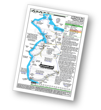
Route Summary:
Rock (Padstow Bay) - The South West Coast Path - Brea Hill - Daymer Bay (Trebetherick) - Trebetherick Point - Greenaway Beach - Broadagogue Cove - Hayle Bay - Trebetherick - Polzeath - New Polzeath - Slipper Point - Pentireglaze Haven - Pentire Point - Pentire Head - Guglane - Rumps Point - Sandinway Beach - Com Head - Pengrit Cove - Downhedge Cove - Pentireglaze - Portkillock Farm - Roserrow - Pityme - Splatt - Stoptide - Rock (Padstow Bay)


