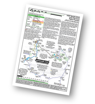
Two easy to follow pub walks from The Boars Head, Higher Poynton, Cheshire, England
To reach The Boars Head, Higher Poynton, in-car SatNav users should select the Latitude/Longitude (Lat Lon) screen and enter:
Lat = N53.34715 and Lon = W 2.0857
Tap/mouse over a coloured circle (1-3 easy walks, 4-6 moderate walks, 7-9 hard walks) and click to select.
Tap/mouse over a coloured circle (1-3 easy walks, 4-6 moderate walks, 7-9 hard walks) and click to select.
Two easy to follow pub walks from The Boars Head, Higher Poynton, Cheshire, England
Scroll down the list of walks below & click on each walk title (in blue) to locate it on the map above.
   |
Vital Statistics:
| Length: | 7 miles (11 km) |
| Ascent: | 824ft (251m) |
| Time: | 3.25hrs |
| Grade: |  |

Route Summary:
Nelson Pit Visitors Centre - Higher Poynton - The Macclesfield Canal - The Cheshire Ring Canal Walk - Wood Lanes - Adlington Basin - Lockgate Farm - The North Cheshire Way - Harrop Brow - West Parkgate - Lyme Park Country Park - Lyme Park Car Park - The Cage - Lyme Hall - Fallow Deer Park - The Lime Avenue - Lyme Park Car Park - Windgather Farm - Haresteads Farm - Nelson Pit Visitors Centre - Higher Poynton.
|
Vital Statistics:
| Length: | 9.75 miles (15.5 km) |
| Ascent: | 9ft (409m) |
| Time: | 5 hrs |
| Grade: |  |
Route Summary:
Nelson Pit Visitors Centre - Higher Poynton - The Macclesfield Canal - The Cheshire Ring Canal Walk - Wood Lanes - Adlington Basin - Lockgate Farm - The North Cheshire Way - Harrop Brow - Birchencliff Farm - Keeper's Cottage - Dale Top - Sponds Moor - The Gritstone Trail - Sponds Hill - Bowstonegate Farm - Bow Stones - Higher Moor - Lyme Park Country Park - Lantern Wood - The Cage - Lyme Hall - Fallow Deer Park - The Lime Avenue - Lyme Park Car Park - Windgather Farm - Haresteads Farm - Nelson Pit Visitors Centre - Higher Poynton.


