Three easy to follow pub walks from The Harrington Arms, Gawsworth, Cheshire, England
To reach The Harrington Arms, Gawsworth, in-car SatNav users should select the Latitude/Longitude (Lat Lon) screen and enter:
Lat = N53.22238 and Lon = W 2.1709
Tap/mouse over a coloured circle (1-3 easy walks, 4-6 moderate walks, 7-9 hard walks) and click to select.
Tap/mouse over a coloured circle (1-3 easy walks, 4-6 moderate walks, 7-9 hard walks) and click to select.
Three easy to follow pub walks from The Harrington Arms, Gawsworth, Cheshire, England
Scroll down the list of walks below & click on each walk title (in blue) to locate it on the map above.
   |
Vital Statistics:
| Length: | 4.5 miles (7 km) |
| Ascent: | 66ft (20m) |
| Time: | 1½ hrs |
| Grade: |  |

Route Summary:
Oakgrove - The Macclesfield Canal - The Cheshire Ring Canal Walk - Gawsworth - Oakgrove
|
Vital Statistics:
| Length: | 7.25 miles (11.5 km) |
| Ascent: | 404ft (123m) |
| Time: | 3 hrs |
| Grade: |  |
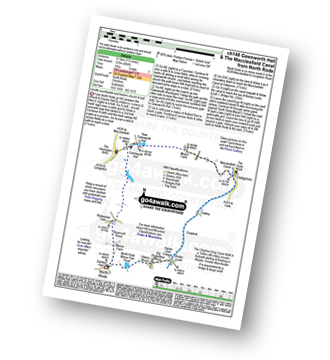
Route Summary:
North Rode - Gawsworth - Oakgrove - The Macclesfield Canal - The Cheshire Ring Canal Walk - Bosley Locks - Big Dogbottom Wood - Station Wood - North Rode Manor Fish Pond - North Rode
|
Vital Statistics:
| Length: | 9.25 miles (15 km) |
| Ascent: | 545ft (166m) |
| Time: | 4 hrs |
| Grade: |  |
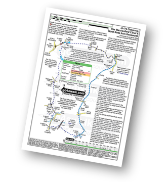
Route Summary:
Gawsworth - Oakgrove - The Macclesfield Canal - The Cheshire Ring Canal Walk - Bosley Locks - River Dane Aquaduct - Railway Viaduct - Crossley Farm - Colleymill Bridge - North Rode - Manor Farm - Beancroft Wood - Rodegreen Farm - Gawsworth


