Three easy to follow pub walks from The Bay Horse, Worsthorne, Lancashire, England
To reach The Bay Horse, Worsthorne, in-car SatNav users should select the Latitude/Longitude (Lat Lon) screen and enter:
Lat = N53.78783 and Lon = W 2.18795
Tap/mouse over a coloured circle (1-3 easy walks, 4-6 moderate walks, 7-9 hard walks) and click to select.
Tap/mouse over a coloured circle (1-3 easy walks, 4-6 moderate walks, 7-9 hard walks) and click to select.
Three easy to follow pub walks from The Bay Horse, Worsthorne, Lancashire, England
Scroll down the list of walks below & click on each walk title (in blue) to locate it on the map above.
   |
Vital Statistics:
| Length: | 6 miles (9.5 km) |
| Ascent: | 814ft (248m) |
| Time: | 3 hrs |
| Grade: |  |

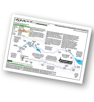
Route Summary:
Mereclough - Rock Water - The Burnley Way - Hurstwood Reservoir - Slipper Hill - Swinden Bridge - The Bronte Way - Lee Green Reservoir - The Burnely Way - Swinden Water - Swinden Valley - Worsthorne - Hurstwood - The River Brunt - Mereclough
|
Vital Statistics:
| Length: | 8.25 miles (13 km) |
| Ascent: | 951ft (290m) |
| Time: | 4 hrs |
| Grade: |  |
Route Summary:
Worsthorne - Gorple Road - Pennine Bridleway - The Burnley Way - Gorple Stones - Gorple Gate - Clough Head Stones - Widdop Reservoir - Rigging Stones - Extwistle Moor - Ing Hey - The Bronte Way - Lee Green Reservoir - The Burnley Way - Swinden Water - Wood Hey Farm - Worsthorne
|
Vital Statistics:
| Length: | 6 miles (9.5 km) |
| Ascent: | 932ft (284m) |
| Time: | 3.25hrs |
| Grade: | |

Route Summary:
Worsthorne - Gorple Road - Gorple Stones - Hare Stone - Cant Clough Reservoir - Hurstwood Reservoir - Hurstwood - Worsthorne


