Two easy to follow pub walks from The Trawden Arms, Trawden, Lancashire, England
To reach The Trawden Arms, Trawden, in-car SatNav users should select the Latitude/Longitude (Lat Lon) screen and enter:
Lat = N53.84531 and Lon = W 2.13504
Tap/mouse over a coloured circle (1-3 easy walks, 4-6 moderate walks, 7-9 hard walks) and click to select.
Tap/mouse over a coloured circle (1-3 easy walks, 4-6 moderate walks, 7-9 hard walks) and click to select.
Two easy to follow pub walks from The Trawden Arms, Trawden, Lancashire, England
Scroll down the list of walks below & click on each walk title (in blue) to locate it on the map above.
   |
Vital Statistics:
| Length: | 7.5 miles (12 km) |
| Ascent: | 1,076ft (328m) |
| Time: | 4 hrs |
| Grade: |  |
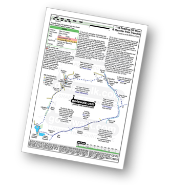
Route Summary:
Trawden - The Pendle Way - Lower Coldwell Reservoir - Upper Coldwell Reservoir - Deerstone Moor - The Bronte Way - Will Moor - Will Moor Clough - Bedding Hill Moor - Saucer Hill Clough - Dean House Farm - Wycoller - Bracken Hill - Trawden
|
Vital Statistics:
| Length: | 9 miles (14.5 km) |
| Ascent: | 1,749ft (533m) |
| Time: | 5 hrs |
| Grade: |  |
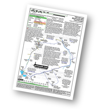
Route Summary:
Trawden - The Pendle Way - Lower Coldwell Reservoir - Upper Coldwell Reservoir - Deerstone Moor - The Bronte Way - Will Moor - Will Moor Clough - Bedding Hill Moor - Abbot Stone (Boulsworth Hill) - Lad Law (Boulsworth Hill) - Saucer Hill Clough - Dean House Farm - Wycoller - Bracken Hill - Trawden


