Five easy to follow pub walks from The Pendle Inn, Barley, Lancashire, England
To reach The Pendle Inn, Barley, in-car SatNav users should select the Latitude/Longitude (Lat Lon) screen and enter:
Lat = N53.85944 and Lon = W 2.27294
Tap/mouse over a coloured circle (1-3 easy walks, 4-6 moderate walks, 7-9 hard walks) and click to select.
Tap/mouse over a coloured circle (1-3 easy walks, 4-6 moderate walks, 7-9 hard walks) and click to select.
Five easy to follow pub walks from The Pendle Inn, Barley, Lancashire, England
Scroll down the list of walks below & click on each walk title (in blue) to locate it on the map above.
   |
Vital Statistics:
| Length: | 3.5 miles (5.5 km) |
| Ascent: | 299ft (91m) |
| Time: | 1½ hrs |
| Grade: |  |
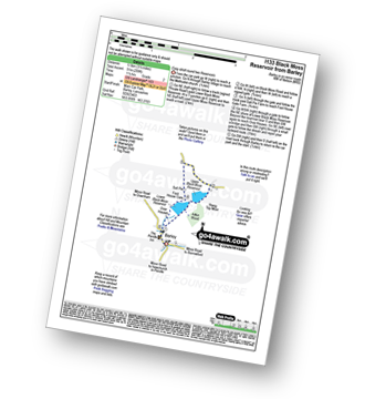
Route Summary:
Barley - Lower Black Moss Reservoir - Upper Black Moss Reservoir - Salt Pie - Foot House Gate - Over Houses - Barley,.
|
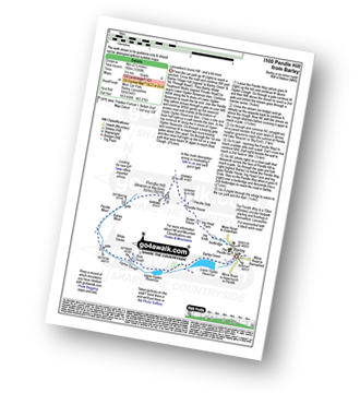
Vital Statistics:
| Length: | 3.75 miles (6 km) |
| Ascent: | 794ft (242m) |
| Time: | 2.25hrs |
| Grade: |  |

Route Summary:
Barley - Barley Green - The Pendle Way - Upper Ogden Reservoir - Fell Wood - Lower Ogden Reservoir - Barley,.
|
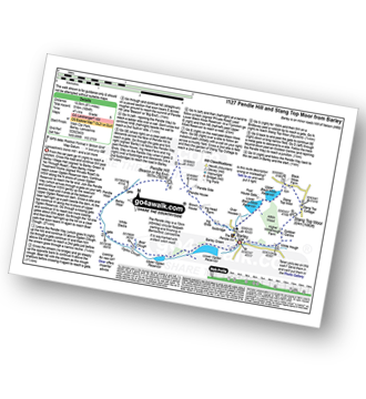
Vital Statistics:
| Length: | 5.5 miles (9 km) |
| Ascent: | 1,280ft (390m) |
| Time: | 3½ hrs |
| Grade: |  |
Route Summary:
Barley - Lower Ogden Reservoir - The Pendle Way - Upper Ogden Reservoir - Boar Clough - Ogden Clough - Pendle Moor - Barley Moor - Pendle Hill (Beacon or Big End) - Pendle House - Ing Head Farm - Ing Ends - Barley
|
Vital Statistics:
| Length: | 4.75 miles (7.5 km) |
| Ascent: | 1,221ft (372m) |
| Time: | 3 hrs |
| Grade: | |

Route Summary:
Barley - Lower Ogden Reservoir - The Pendle Way - Upper Ogden Reservoir - Boar Clough - Pendle Moor - Barley Moor - Pendle Hill (Beacon or Big End) - Pendle House - Ing Head Farm - Ing Ends - Barley,.
|
Vital Statistics:
| Length: | 8.5 miles (13.5 km) |
| Ascent: | 1,694ft (516m) |
| Time: | 4.75hrs |
| Grade: |  |
Route Summary:
Barley - Lower Ogden Reservoir - The Pendle Way - Upper Ogden Reservoir - Boar Clough - Ogden Clough - Pendle Moor - Barley Moor - Pendle Hill (Beacon or Big End) - Pendle House - Ing Head Farm - Ing Ends - Barley - Lower Black Moss Reservoir - Upper Black Moss Reservoir - Stang Top Moor - White Hough - Barley


