Two easy to follow pub walks from The Hanging Gate, Pot Lords, The Peak District, Cheshire, England
To reach The Hanging Gate, Pot Lords, in-car SatNav users should select the Latitude/Longitude (Lat Lon) screen and enter:
Lat = N53.22380 and Lon = W 2.07255
Tap/mouse over a coloured circle (1-3 easy walks, 4-6 moderate walks, 7-9 hard walks) and click to select.
Tap/mouse over a coloured circle (1-3 easy walks, 4-6 moderate walks, 7-9 hard walks) and click to select.
Two easy to follow pub walks from The Hanging Gate, Pot Lords, The Peak District, Cheshire, England
Scroll down the list of walks below & click on each walk title (in blue) to locate it on the map above.
   |
Vital Statistics:
| Length: | 7.25 miles (11.5 km) |
| Ascent: | 1,598ft (487m) |
| Time: | 4.25hrs |
| Grade: |  |

Route Summary:
Ridgegate Reservoir - Leather's Smithy - Trentabank Reservoir - Higher Ridgegate - Macclesfield Forest - Shutlingsloe - Wildboarclough - Higher Nabbs Farm - Oaken Clough - Oakenclough Farm - Pot Lords - The Hanging Gate - The Gritstone Trail - Throstles Nest Farm - Ridgegate Reservoir
|
Vital Statistics:
| Length: | 8.5 miles (13.5 km) |
| Ascent: | 1,690ft (515m) |
| Time: | 4.75hrs |
| Grade: | |
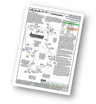
Route Summary:
The Hanging Gate - Pot Lords - High Lee Farm - Withenshaw - Cessbank Common - Longgutter - Lower Greasley Farm - Greasley Hollow - Mareknowles Farm - The Gritstone Trail - Wincle Minn - Golden Slack - Croker Hill - Sutton Common - Foxbank Farm - Higher Sutton - Lowerhouse Farm - The Hanging Gate


