One easy to follow pub walk from The Running Horses, Mickleham, Surrey, England
To reach The Running Horses, Mickleham, in-car SatNav users should select the Latitude/Longitude (Lat Lon) screen and enter:
Lat = N51.26826 and Lon = W 0.32401
Tap/mouse over a coloured circle (1-3 easy walks, 4-6 moderate walks, 7-9 hard walks) and click to select.
Tap/mouse over a coloured circle (1-3 easy walks, 4-6 moderate walks, 7-9 hard walks) and click to select.
One easy to follow pub walk from The Running Horses, Mickleham, Surrey, England
Scroll down the list of walks below & click on each walk title (in blue) to locate it on the map above.
   |
Vital Statistics:
| Length: | 7 miles (11 km) |
| Ascent: | 1,115ft (340m) |
| Time: | 3½ hrs |
| Grade: |  |
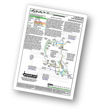
Route Summary:
Car Park S of Mickleham - River Mole - Norbury Park House - Fetcham Downs - Westhumble - The North Downs Way - Box Hill - Car Park S of Mickleham


