The Mountains, Peaks, Tops and Hills in The Moelwyns area of Snowdonia, Conwy and Gwynedd with all the tops you have already bagged in first & then the ones you are yet to climb second.
The Moelwyns area of Snowdonia National Park, Conwy and Gwynedd is enclosed by:
- The A498 via Llyn Gwynant, Nant Gwynant, Llyn Dinas & Dyffryn Mymbyr to the North West
- Capel Curig and Betws-y-Coed to the North
- Afon Machno to the East & South East
- The Vale of Ffestinog to the South
- The A4085 from Penrhyndeudraeth to Beddgelert to the West
If you include just the Mountains (Hewitts) and the Nuttalls there are 15 tops to climb, bag & conquer and the highest point is Carnedd Moel Siabod at 872m (2,861ft).
To see these Mountains, Peaks, Tops and Hills displayed in different ways - see the options in the left-hand column and towards the bottom of this page.
![]() Your Personal Bagging Record for The Moelwyns area of Snowdonia
Your Personal Bagging Record for The Moelwyns area of Snowdonia
LOG ON and RELOAD this page to show which Mountains, Peaks, Tops and Hills you have already climbed, bagged & conquered [. . . more details]
Scroll down this list of mountains, peaks, tops & hills below and tap/click on each name (in blue) to locate it on the map above.
See this list in: Alphabetical Order | Height Order‡
To reverse the order select the link again.
Mountain, Peak, Top or Hill already bagged:
Bagged
Top yet to be climbed, bagged & conquered:
Bagged

![]()
1. Carnedd Moel Siabod
872m (2861ft)
Mountain (Hewitt) and Nuttall
See more details, photos, trip reports and easy-to-follow walks up Carnedd Moel Siabod
![]()
2. Moelwyn Mawr
770m (2527ft)
Mountain (Hewitt) and Nuttall
See more details, photos, trip reports and easy-to-follow walks up Moelwyn Mawr
![]()
3. Moelwyn Bach
710m (2330ft)
Mountain (Hewitt) and Nuttall
See more details, photos, trip reports and easy-to-follow walks up Moelwyn Bach
![]()
4. Allt-fawr (Moelwyns)
698m (2291ft)
Mountain (Hewitt) and Nuttall
See more details, photos, trip reports and easy-to-follow walks up Allt-fawr (Moelwyns)

![]()
5. Craigysgafn
689m (2263ft)
Nuttall
See more details, photos, trip reports and easy-to-follow walks up Craigysgafn
![]()
6. Cnicht
689m (2260ft)
Mountain (Hewitt) and Nuttall
See more details, photos, trip reports and easy-to-follow walks up Cnicht
![]()
7. Cnicht (North Top)
688m (2257ft)
Nuttall
See more details, photos, trip reports and easy-to-follow walks up Cnicht (North Top)
![]()
8. Moel Druman
676m (2219ft)
Mountain (Hewitt) and Nuttall
See more details, photos, trip reports and easy-to-follow walks up Moel Druman
![]()
9. Ysgafell Wen
672m (2206ft)
Mountain (Hewitt) and Nuttall
See more details, photos, trip reports and easy-to-follow walks up Ysgafell Wen
![]()
10. Ysgafell Wen (North Top)
669m (2195ft)
Mountain (Hewitt) and Nuttall
See more details, photos, trip reports and easy-to-follow walks up Ysgafell Wen (North Top)
![]()
11. Manod Mawr
661m (2169ft)
Mountain (Hewitt) and Nuttall
See more details, photos, trip reports and easy-to-follow walks up Manod Mawr
![]()
12. Ysgafell Wen (Far North Top)
659m (2162ft)
Nuttall
See more details, photos, trip reports and easy-to-follow walks up Ysgafell Wen (Far North Top)
![]()
13. Manod Mawr (North Top)
658m (2160ft)
Mountain (Hewitt) and Nuttall
See more details, photos, trip reports and easy-to-follow walks up Manod Mawr (North Top)
![]()
14. Moel-yr-hydd
648m (2127ft)
Mountain (Hewitt) and Nuttall
See more details, photos, trip reports and easy-to-follow walks up Moel-yr-hydd
![]()
15. Moel Penamnen
628m (2061ft)
Mountain (Hewitt) and Nuttall
See more details, photos, trip reports and easy-to-follow walks up Moel Penamnen
![]() Your Personal Bagging Record for The Moelwyns area of Snowdonia
Your Personal Bagging Record for The Moelwyns area of Snowdonia
LOG ON and RELOAD this page to show which Mountains, Peaks, Tops and Hills you have already climbed, bagged & conquered [. . . more details]
View these 15 Mountains, Peaks, Tops and Hills:
- On a Downloadable PDF you can Print or Save to your Phone#
- On an Interactive Google Map with a list of tops below it.
(makes it easier to locate a particular top) - On a Detailed List in:
Alphabetical Order | Height Order - On one page with 'yet-to-be-bagged' listed 1st
& then 'already-bagged' tops listed 2nd in:
Alphabetical Order | Height Order - On one page with 'already-bagged' tops listed 1st
& then 'yet-to-be-bagged' tops listed 2nd in:
Alphabetical Order | Height Order
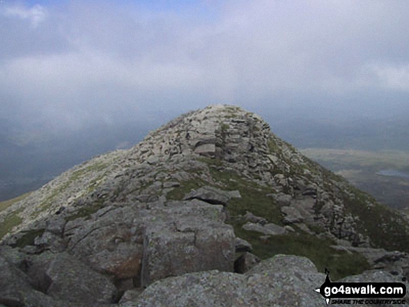 Carnedd Moel Siabod in The Moelwyns area of Snowdonia
Photo: Davie Naylor
# Whether you print a copy or download it to your phone, this Peak Baggers' Map will prove incredibly useful if you want to know what's what when you are up in the mountains and cannot get a phone signal.
Is there a Mountain, Peak, Top or Hill missing from the above google map or list?