The Mountains, Peaks, Tops and Hills in The Moel Hebog area area of Snowdonia, Gwynedd with all the tops you have already bagged in first & then the ones you are yet to climb second.
The Moel Hebog area area of Snowdonia National Park, Gwynedd is enclosed by:
- Llanberis the A4085 via Nant y Betws, Llyn Cwellyn & Nant Conwyn to the North East
- Beddgelert, the A498 and Prenteg to the East
- Trenlog to the South
- The edge of the Snowdonia National Park to the West
If you include just the Mountains (Hewitts) and the Nuttalls there are 11 tops to climb, bag & conquer and the highest point is Moel Hebog at 783m (2,569ft).
To see these Mountains, Peaks, Tops and Hills displayed in different ways - see the options in the left-hand column and towards the bottom of this page.
![]() Your Personal Bagging Record for The Moel Hebog area area of Snowdonia
Your Personal Bagging Record for The Moel Hebog area area of Snowdonia
LOG ON and RELOAD this page to show which Mountains, Peaks, Tops and Hills you have already climbed, bagged & conquered [. . . more details]
Scroll down this list of mountains, peaks, tops & hills below and tap/click on each name (in blue) to locate it on the map above.
See this list in: Alphabetical Order | Height Order‡
To reverse the order select the link again.
Mountain, Peak, Top or Hill already bagged:
Bagged
Top yet to be climbed, bagged & conquered:
Bagged

![]()
1. Moel Hebog
783m (2569ft)
Mountain (Hewitt) and Nuttall
See more details, photos, trip reports and easy-to-follow walks up Moel Hebog
![]()
2. Craig Cwm Silyn
734m (2409ft)
Mountain (Hewitt) and Nuttall
See more details, photos, trip reports and easy-to-follow walks up Craig Cwm Silyn
![]()
3. Trum y Ddysgl
709m (2327ft)
Mountain (Hewitt) and Nuttall
See more details, photos, trip reports and easy-to-follow walks up Trum y Ddysgl

![]()
4. Garnedd-goch
700m (2297ft)
Nuttall
See more details, photos, trip reports and easy-to-follow walks up Garnedd-goch
![]()
5. Mynydd Mawr (Llyn Cwellyn)
698m (2291ft)
Mountain (Hewitt) and Nuttall
See more details, photos, trip reports and easy-to-follow walks up Mynydd Mawr (Llyn Cwellyn)
![]()
6. Mynydd Drws-y-coed
695m (2281ft)
Mountain (Hewitt) and Nuttall
See more details, photos, trip reports and easy-to-follow walks up Mynydd Drws-y-coed
![]()
7. Moel yr Ogof
655m (2150ft)
Mountain (Hewitt) and Nuttall
See more details, photos, trip reports and easy-to-follow walks up Moel yr Ogof
![]()
8. Mynydd Tal-y-mignedd
653m (2143ft)
Mountain (Hewitt) and Nuttall
See more details, photos, trip reports and easy-to-follow walks up Mynydd Tal-y-mignedd
![]()
9. Moel Lefn
638m (2094ft)
Mountain (Hewitt) and Nuttall
See more details, photos, trip reports and easy-to-follow walks up Moel Lefn
![]()
10. Y Garn (Moel Hebog)
633m (2078ft)
Nuttall
See more details, photos, trip reports and easy-to-follow walks up Y Garn (Moel Hebog)
![]()
11. Mynydd Graig Goch
610m (2000ft)
Mountain (Hewitt) and Nuttall
See more details, photos, trip reports and easy-to-follow walks up Mynydd Graig Goch
![]() Your Personal Bagging Record for The Moel Hebog area area of Snowdonia
Your Personal Bagging Record for The Moel Hebog area area of Snowdonia
LOG ON and RELOAD this page to show which Mountains, Peaks, Tops and Hills you have already climbed, bagged & conquered [. . . more details]
View these 11 Mountains, Peaks, Tops and Hills:
- On a Downloadable PDF you can Print or Save to your Phone#
- On an Interactive Google Map with a list of tops below it.
(makes it easier to locate a particular top) - On a Detailed List in:
Alphabetical Order | Height Order - On one page with 'yet-to-be-bagged' listed 1st
& then 'already-bagged' tops listed 2nd in:
Alphabetical Order | Height Order - On one page with 'already-bagged' tops listed 1st
& then 'yet-to-be-bagged' tops listed 2nd in:
Alphabetical Order | Height Order
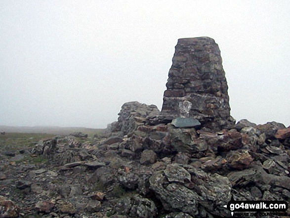 The summit of Moel Hebog in The Moel Hebog area of Snowdonia
Photo: Paul Latham
# Whether you print a copy or download it to your phone, this Peak Baggers' Map will prove incredibly useful if you want to know what's what when you are up in the mountains and cannot get a phone signal.
Is there a Mountain, Peak, Top or Hill missing from the above google map or list?