The Mountains, Peaks, Tops and Hills in The South Eastern Marches area of The Lake District, Cumbria with all the tops you have already bagged in first & then the ones you are yet to climb second.
The South Eastern Marches area of The Lake District National Park, Cumbria is the area enclosed by:
- The A591 from Ambleside towards Kendal to the North
- The new National Park boundary to Morecambe Bay to the East
- Morecambe Bay to the A590 at Greenodd to the South
- The A590 to Newby Bridge and then the shore of Lake Winderemere to Ambleside to the West
If you count only the Wainwright Outlying Fells there are 11 tops to climb, bag & conquer and the highest point is Brunt Knott (South Top) at 395m (1,296ft).
To see these Mountains, Peaks, Tops and Hills displayed in different ways - see the options in the left-hand column and towards the bottom of this page.
![]() Your Personal Bagging Record for The South Eastern Marches area of The Lake District
Your Personal Bagging Record for The South Eastern Marches area of The Lake District
LOG ON and RELOAD this page to show which Mountains, Peaks, Tops and Hills you have already climbed, bagged & conquered [. . . more details]
Scroll down this list of mountains, peaks, tops & hills below and tap/click on each name (in blue) to locate it on the map above.
See this list in: Alphabetical Order‡ | Height Order
To reverse the order select the link again.
Mountain, Peak, Top or Hill already bagged:
Bagged
Top yet to be climbed, bagged & conquered:
Bagged

![]()
1. Brunt Knott (East Top)
390m (1279ft)
Wainwright Outlying Fell
See more details, photos, trip reports and easy-to-follow walks up Brunt Knott (East Top)
![]()
2. Brunt Knott (South Top)
395m (1296ft)
Wainwright Outlying Fell
See more details, photos, trip reports and easy-to-follow walks up Brunt Knott (South Top)
![]()
3. Cunswick Scar
207m (679ft)
Wainwright Outlying Fell
See more details, photos, trip reports and easy-to-follow walks up Cunswick Scar
![]()
4. Dixon Heights (Newton Fell)
177m (581ft)
Wainwright Outlying Fell
See more details, photos, trip reports and easy-to-follow walks up Dixon Heights (Newton Fell)
![]()
5. Grandsire (South West Top)
247m (810ft)
Wainwright Outlying Fell
See more details, photos, trip reports and easy-to-follow walks up Grandsire (South West Top)
![]()
6. Hugill Fell
256m (840ft)
Wainwright Outlying Fell
See more details, photos, trip reports and easy-to-follow walks up Hugill Fell
![]()
7. Lord's Seat (Whitbarrow Scar)
215m (706ft)
Wainwright Outlying Fell
See more details, photos, trip reports and easy-to-follow walks up Lord's Seat (Whitbarrow Scar)
![]()
8. Reston Scar
255m (837ft)
Wainwright Outlying Fell
See more details, photos, trip reports and easy-to-follow walks up Reston Scar
![]()
9. Saskills (Newton Fell)
235m (771ft)
Wainwright Outlying Fell
See more details, photos, trip reports and easy-to-follow walks up Saskills (Newton Fell)
![]()
10. Scout Scar (Barrowfield)
233m (765ft)
Wainwright Outlying Fell
See more details, photos, trip reports and easy-to-follow walks up Scout Scar (Barrowfield)
![]()
11. Ulgraves (Potter Fell)
333m (1093ft)
Wainwright Outlying Fell
See more details, photos, trip reports and easy-to-follow walks up Ulgraves (Potter Fell)
![]() Your Personal Bagging Record for The South Eastern Marches area of The Lake District
Your Personal Bagging Record for The South Eastern Marches area of The Lake District
LOG ON and RELOAD this page to show which Mountains, Peaks, Tops and Hills you have already climbed, bagged & conquered [. . . more details]
View these 11 Mountains, Peaks, Tops and Hills:
- On an Interactive Google Map with a list of tops below it.
(makes it easier to locate a particular top) - On a Detailed List in:
Alphabetical Order | Height Order - On one page with 'yet-to-be-bagged' listed 1st
& then 'already-bagged' tops listed 2nd in:
Alphabetical Order | Height Order - On one page with 'already-bagged' tops listed 1st
& then 'yet-to-be-bagged' tops listed 2nd in:
Alphabetical Order | Height Order
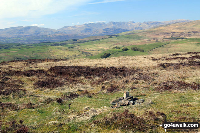 The summit of Brunt Knott (South Top) in The South Eastern Marches area of The Lake District
Photo: Andy Lyons
Is there a Mountain, Peak, Top or Hill missing from the above google map or list?