GPS Waypoints for Walking Wainwright's Coast to Coast Walk (c2c) from St Bees Head to Robin Hood's Bay
Download all 192 GPS Waypoints (requires 1 credit) and the GPS Waypoint Key (requires 1 credit) for Walking Wainwright's Coast to Coast Walk (c2c) from St Bees Head to Robin Hood's Bay.
Walk Wainwright's Coast to Coast Walk (c2c) from St Bees Head to Robin Hood's Bay
 GPS Waypoint Key for walking
Wainwright's Coast to Coast Walk
Wainwright's Coast to Coast Walk (c2c) is a 304km (190 miles) footpath connecting The Irish Sea at St Bees in Cumbria with The North Sea at Robin Hood's Bay in North Yorkshire.
The route was originally devised by Alfred Wainwright for his 1973 book and passes through three National Parks (The Lake District National Park, The Yorkshire Dales National Park and The North York Moors National Park) and some of the finest scenery this country has to offer.
Despite its popularity, the route remain unofficial and will probably remain so.
Indeed it was Wainwright's intention that you should devise your own route connecting the two seas rather than follow his suggestion. Subsequently it is not marked on any OS Maps*, quite poorly signposted on the ground and impossible to follow without a proper guide.
Of course it is possible to walk the whole route without GPS, but these GPS Waypoints will enable you to either:
- quickly establish their current position and/or
- see how far it is to the next point of interest (like a shop or a bed for the night).
Download all 192 GPS Waypoints (requires 1 credit) and the GPS Waypoint Key (requires 1 credit) for Walking Wainwright's Coast to Coast Walk (c2c) from St Bees Head to Robin Hood's Bay.
Download GPS Waypoints for Walking Wainwright's Coast to Coast Walk (c2c) from St Bees Head to Robin Hood's Bay
So here are 192 GPS Waypoints covering (Wainwright's version of) the route from the start at St Bees Head to the finish at Robin Hood's Bay. (Most people go west to east due partly to the prevailing weather conditions and partly to get the big mountains of the Lake District out of the way early(ish) on).
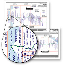
Each Waypoint has a 'CC-[number]' designation which relates to a named location on the accompanying GPS Waypoint Key (see the example above). NB. You will need to take both as the GPS Waypoints will make no sense without the GPS Waypoint Key. The GPS Waypoint Key is only two pages so you can print it on either side of a single sheet of A4 paper and keep it in a plastic A4 wallet in your pocket.
We have done it this way because most GPS Devices only allow Waypoint names with 6 characters or less. Whilst the first waypoint at St Bees is easy to name - it would soon get rather enigmatic as we travel across the country - so our Waypoints are numbered CC-000 St Bees, CC-001 St Bees Head, CC-002 North Head . . . all the way to . . . CC-189 Ness Point or North Cheek, CC-190 Robin Hood's Bay (top) and finally CC-191 Robin Hood's Bay (the sea).
GPS Position Format and Datum:
You must set your GPS device to:
- Position Format = British Grid and
- Map Datum = ord srvy GB
This system enables you to easily find any particular waypoint in your GPS as well as creating a 'Route' for all or part of the walk depending on how much you intend to tackle. Many people walk the Coast to Coast in sections - often taking several years to complete the whole route.
As always, if you have any thoughts on this - good, bad or indifferent - let us know at Feedback
Download all 192 GPS Waypoints (requires 1 credit) and the GPS Waypoint Key (requires 1 credit) for Walking Wainwright's Coast to Coast Walk (c2c) from St Bees Head to Robin Hood's Bay.
Ordnance Survey Maps required to walk Wainwright's Coast to Coast Walk
The Ordnance Survey Maps you will need to complete Wainwright's Coast to Coast Walk are (in order from St Bees to Robin Hood's Bay):
- 303 Whitehaven & Workington
- OL4 The English Lakes - North-eastern area
- OL5 The English Lakes - North-western area
- OL7 The English Lakes - South-western area
- OL19 Howgill Fells and Upper Eden Valley
- OL30 Yorkshire Dales – Northern & Central areas
- 302 Northallerton & Thirsk
- OL26 North York Moors – Western area and
- OL27 North York Moors – Eastern area
*In conjunction with Michael Joseph Ltd, The Ordnance Survey produced two 1:25,000 scale 'strip' maps detailing Wainwright's version of the Coast to Coast Walk - OL33 (ISBN 0-319-26061-5) and OL34 (ISBN 0-319-26046-1). As far as we are aware these maps are no longer in print.
So how long is Wainwright's Coast to Coast walk?
NB. Somewhat surprisingly, no-one seems to be able to agree how long the Coast to Coast Path is. Alfred Wainwright himself and a sign at the start suggests it is 190 miles (304km) but a sign at the finish states it is 192 miles (307.2km).
However, all we can say is that when we measured it having:
- headed up Ennerdale rather than following the high level 'High Stile Ridge' route,
- not walked into Grasmere
- walked down Grisedale rather than following either the high level Helvellyn or St Sunday Crag alternatives and
- follow the amended route rather than Wainwright's 1973 original (which crossed privately owned land)
then Wainwright's Coast to Coast Walk is 304km (190 miles) long.
Download all 192 GPS Waypoints (requires 1 credit) and the GPS Waypoint Key (requires 1 credit) for Walking Wainwright's Coast to Coast Walk (c2c) from St Bees Head to Robin Hood's Bay.


