GPS Waypoints for Walking The Pennine Way from Edale to Kirk Yetholm
Walk The Pennine Way from Edale to Kirk Yetholm
 GPS Waypoint Key for walking
The Pennine Way
The Pennine Way is a 410km (257 miles)* national footpath connecting connecting Edale in Derbyshire with Kirk Yetholm in the Borders. It is waymarked by a National Trail Acorn.
Because it is an official National Trail it is very well marked on the ground, very well marked on the appropriate Ordnance Survey Maps (see below) and is easy to follow providing you have basic map reading and compass skills.
It is perfectly possible to walk the whole route without the aid of GPS, however, we have received more than a few requests for GPS Waypoints for the route to enable Pennine Wayfarers to either:
- quickly establish their current position and/or
- see how far it is to the next point of interest (like a shop or a bed for the night).
Download all 219 GPS Waypoints (requires 1 credit) and the GPS Waypoint Key (requires 1 credit) for Walking The Pennine Way from Edale to Kirk Yetholm.
Download GPS Waypoints for Walking The Pennine Way from Edale to Kirk Yetholm
So here are 219 GPS Waypoints covering the route from the start at Edale to the finish at Kirk Yetholm. (Most people go south).
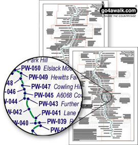
Each Waypoint has a 'PW-[number]' designation which relates to a named location on the accompanying GPS Waypoint Key (see the example above). NB. You will need to take both as the GPS Waypoints will make no sense without the GPS Waypoint Key. The GPS Waypoint Key is only two pages so you can print it on either side of a single sheet of A4 paper and keep it in a plastic A4 wallet in your pocket.
We have done it this way because most GPS Devices only allow Waypoint names with 6 characters or less. Whilst the first waypoint at Edale is easy to name - it would soon get rather enigmatic as we travel up the trail - so our Waypoints are numbered PW-000 Edale, PW-001 Upper Booth, PW-002 2nd Cairn above Jacob's Ladder . . . all the way to . . . PW-216 England Scotland Border (final visit), PW-217 Burnhead and finally PW-218 Kirk Yetholm.
GPS Position Format and Datum:
You must set your GPS device to:
- Position Format = British Grid and
- Map Datum = ord srvy GB
This system enables you to easily find any particular waypoint in your GPS as well as creating a 'Route' for all or part of the walk depending on how much you intend to tackle. Many people walk The Pennine Way in sections - often taking several years to complete the whole route.
As always, if you have any thoughts on this - good, bad or indifferent - let us know at Feedback
Download all 219 GPS Waypoints (requires 1 credit) and the GPS Waypoint Key (requires 1 credit) for Walking The Pennine Way from Edale to Kirk Yetholm.
Ordnance Survey Maps required to walk The Pennine Way
The Ordnance Survey Maps you will need to complete The Pennine Way are (in order from Edale to Kirk Yetholm):
- OL1 The Peak District – Dark Peak area
- OL21 South Pennines
- OL2 Yorkshire Dales – Southern & Western areas
- OL30 Yorkshire Dales – Northern & Central areas
- OL19 Howgill Fells and Upper Eden Valley
- OL31 North Pennines – Teesdale & Weardale
- OL43 Hadrian’s Wall
- OL42 Kielder Water and
- OL16 The Cheviot Hills
So how long is The Pennine Way?
NB. Somewhat surprisingly, no-one seems to be able to agree how long The Pennine Way is. Alfred Wainwright in his Pennine Way Guide Book thought it is 432km (270 miles), the official The National Trails site claims it is 428.8km (268 miles) and the Long Distance Walkers Association publish it as 404km (251 miles).
However, all we can say is that when we measured it having:
- taken the Wessenden Alternative off Black Hill (Soldier's Lump) (recommended during/after wet weather),
- taken the detour to visit Hawes in North Yorkshire (you'll probably want to spend the night there anyway) and
- visit the summit of The Cheviot in Northumberland - a 4km detour to the highest point in Northumberland. (Hey, if you've walked this far already it would be a shame to miss it . . . )
. . . then The Pennine Way is 410.5km (257miles) long.
And that's official.
Download all 219 GPS Waypoints (requires 1 credit) and the GPS Waypoint Key (requires 1 credit) for Walking The Pennine Way from Edale to Kirk Yetholm.
Some feedback about go4awalk.com's GPS Waypoints for The Pennine Way
"Just wanted to let you know that on the day I left for the UK, prior to my solo walk of the Pennine Way in October 2006, I decided to download the GPS waypoints for the Pennine Way. They saved my life. As I climbed to the top of Kinder Plateau, the weather changed in an instant from a beautiful fall day to 40 knot winds, sheets of rain, and mist and fog which limited my visibility to ten meters. Map and compass were useless and I quickly became lost. My GPS allowed me to get a bearing on the Kinder Downfall, hidden in the fog. The stream was so swollen and fast moving it took me a half hour to cross.
Later the same day, I also became hopelessly lost on Bleaklow, and again, your GPS waypoint delivered me from that morass of streams and channels. Sincerely, "
Greg Leck, Bangor, Pennsylvania, USA - Jan 2007
Download all 219 GPS Waypoints (requires 1 credit) and the GPS Waypoint Key (requires 1 credit) for Walking The Pennine Way from Edale to Kirk Yetholm.


